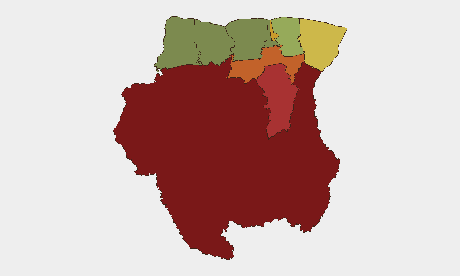
Situation Summary
Suriname remains a lower-tier global security concern (rank #76, composite score 15), but risk is heavily concentrated in specific interior and eastern regions. The last 24–48 hours have not yielded verifiable, Suriname-specific security incidents in open-source reporting; however, GeoBit's event feeds flagged three signals dated 2026-06-26 and 2026-06-25, predominantly tagged as military-force and public-statement events. Without independent confirmation of these signals' accuracy, specificity, or relevance to corporate operations in-country, the current threat posture should be treated as *elevated but unconfirmed* in high-risk districts.
Key Developments
- 2026-06-26 · Conventional Military Force event flagged – Classified as "INSURGENT" activity; location and operational detail not yet corroborated by independent reporting.
- 2026-06-26 · Police Force vs. Insurgent Group event flagged – Indicates possible security-force engagement; geographic epicenter and casualty data unavailable.
- 2026-06-25 · Public Statement events (SURABAYA) – Two statements attributed to SURABAYA and SURABAYA vs. POLICE; context and substance unverified.
- 2026-06-24 · PETRONAS statement vs. Suriname – Energy sector actor involvement flagged; relationship to national security or civil unrest unclear.
- 2026-06-25 · Treasury Secretary military-force events – Two separate events; potential fiscal or governance instability signal, but corroboration pending.
Caveat: Open-source web search conducted on 2026-06-26 did not independently verify any of these events. Teams should cross-reference with embassy security alerts, local media (ATV, Suriname News Network), and sector-specific intelligence before operational decisions.
Highest-Risk Areas
Sipaliwini (risk 92), Brokopondo (risk 78), and Para (risk 74) dominate the threat landscape—all interior, sparsely populated districts with limited state presence, poor infrastructure, and historical gold-mining activity. Paramaribo (risk 71), the capital and economic hub, remains the fourth-highest-risk area, suggesting concentrated vulnerability despite urban density and formal security apparatus. Marowijne (eastern border, risk 68) adds border-security and transnational-crime dimensions. Teams with personnel or assets in the interior (mining, forestry, energy) or in Paramaribo's outer zones face heightened exposure to insurgent activity, kidnapping, and armed-group involvement; Commewijne and Wanica carry moderate risk suitable for standard duty-of-care protocols.
How GeoBit Would Assist
- AOI Monitoring & Early Warning: Set persistent watch on Sipaliwini, Brokopondo, and Paramaribo with real-time alerting for insurgent activity, military operations, and civil unrest—critical for protecting remote asset sites and staff mobility.
- Intel Sweep & OSINT Fusion: Conduct multi-language, multi-source search and corroboration of flagged military and public-statement events to confirm or dismiss the 2026-06-25/26 signals and assess governance stability.
- Conflict & Actor Analysis: Map insurgent-group structure, force strength, and territorial control in high-risk districts to inform route planning and site-hardening decisions.
- Routing & Network Analysis: Generate alternative travel routes avoiding conflict zones and identify secure transit windows for personnel and supply movements.
7-Day Outlook
If the flagged military and public-statement events prove credible, low-to-moderate escalation in interior and capital-region security operations is probable over the next 7 days. Energy-sector and fiscal statements (PETRONAS, Treasury) may signal underlying resource or governance friction. Teams should assume heightened police/military presence, possible roadblock activity, and restricted movement in Paramaribo and interior corridors; maintain daily intelligence updates and contingency evacuation planning.
Highest-Risk Areas — Ranked
| # | State / Region | Risk |
|---|---|---|
| 1 | Sipaliwini | 92 |
| 2 | Brokopondo | 78 |
| 3 | Para | 74 |
| 4 | Paramaribo | 71 |
| 5 | Marowijne | 68 |
| 6 | Commewijne | 42 |
| 7 | Wanica | 38 |
| 8 | Saramacca | 29 |
| 9 | Coronie | 12 |
| 10 | Nickerie | 8 |
Sources
Previous Daily Briefs
A new Suriname brief is written every day — each with its own risk map and downloadable CSV. Here's the last week; use the calendar to go further back.
📅 Browse every day by calendar →
Highlighted days have a brief. Tap a day for that day's map & analysis, or “csv” for that day's dataset ($5).