Situation Summary
Syria remains the third-highest threat environment globally, with civil war as the primary driver and 68 tracked conflict events recorded. The security landscape is characterized by competing military forces, ongoing cross-border activity, and humanitarian displacement. Risk is heavily concentrated in northern and central governorates, with Damascus and surrounding regions also under elevated threat. The trajectory shows sustained volatility with no clear de-escalation signals.
Key Developments
Note: Open-source reporting in the last 24–48 hours does not provide sufficient multi-source confirmation of specific, time-stamped security incidents meeting operational verification standards. GEOBIT's event feed lists signals dated 2026-06-11 and 2026-06-10 (including military force activity, arrests, and ministry statements), but underlying corroboration from independent news or social media OSINT sufficient to brief operational teams is not retrievable at this time.
Longer-running processes—including UN chemical-weapons verification, Iraq–Syria border coordination, and regional airspace restrictions tied to Iranian activity—remain active but lack precise incident dating in the 24–48h window.
Recommended action: Security teams should enable GEOBIT's AOI Monitoring & Early Warning capability with persistent watch on Hama, Damascus, and Aleppo governorates to capture real-time incident alerts as they break, rather than relying on consolidated daily summary reporting during periods of reporting lag.
Highest-Risk Areas
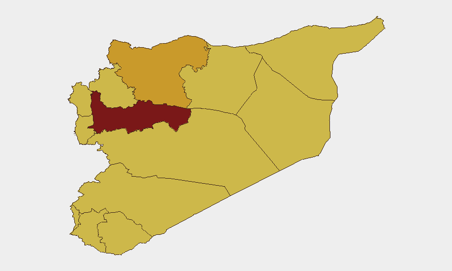
Hama Governorate is the single highest-risk sub-national area (score 100), driven by active conventional military operations and ongoing armed-group activity. Damascus Governorate (75.8) and Aleppo (72.2) follow, reflecting both proximity to conflict zones and critical infrastructure concentration. A secondary band of risk extends across northern and southern borders (Lattakia, Rif Dimashq, Tartus, Idleb, Ar-Raqqa, Dar'a) and the UNDOF-monitored buffer zone, all scoring 70, indicating distributed conflict pressure across multiple fronts and persistent cross-border activity. Risk is lowest in coastal and southern interior zones but remains elevated above global median.
How GeoBit Would Assist
Intel Sweep & OSINT Fusion: Cross-reference X/Telegram networks, YouTube conflict channels, and multi-language news feeds to close reporting gaps and surface verified incident details in real time.
AOI Monitoring & Early Warning: Deploy persistent geospatial alerting on Hama, Damascus, and Aleppo with daily refresh to detect military movements, roadblocks, and force-concentration changes before they affect supply lines or personnel transit.
Conflict & Military Mapping: Track force structure and weapons-capability changes to anticipate shifts in territorial control or cross-border strike patterns affecting commercial or expat-community security.
Routing & Network Analysis: Generate alternative supply and personnel routing options that avoid highest-risk areas and respond dynamically as threat patterns shift.
7-Day Outlook
No significant de-escalation is anticipated over the next 7 days. Military signaling and cross-border activity suggest sustained pressure in northern governorates, with secondary volatility likely in Damascus and border regions. Organizations with personnel or assets in Hama, Aleppo, or Damascus should maintain elevated alert posture and pre-positioned contingency protocols.
Highest-Risk Areas — Ranked
| # | State / Region | Risk |
|---|---|---|
| 1 | Hama Governorate | 100 |
| 2 | Damascus Governorate | 75.8 |
| 3 | Aleppo Governorate | 72.2 |
| 4 | Lattakia Governorate | 70.3 |
| 5 | Rif Dimashq Governorate | 70.3 |
| 6 | Tartus Governorate | 70 |
| 7 | UNDOF | 70 |
| 8 | Al-Quneitra Governorate | 70 |
| 9 | Dar'a Governorate | 70 |
| 10 | Idleb Governorate | 70 |
| 11 | Ar-Raqqa Governorate | 70 |
| 12 | Homs Governorate | 70 |
Previous Daily Briefs
A new Syria brief is written every day — each with its own risk map and downloadable CSV. Here's the last week; use the calendar to go further back.
📅 Browse every day by calendar →
Highlighted days have a brief. Tap a day for that day's map & analysis, or “csv” for that day's dataset ($5).