Situation Summary
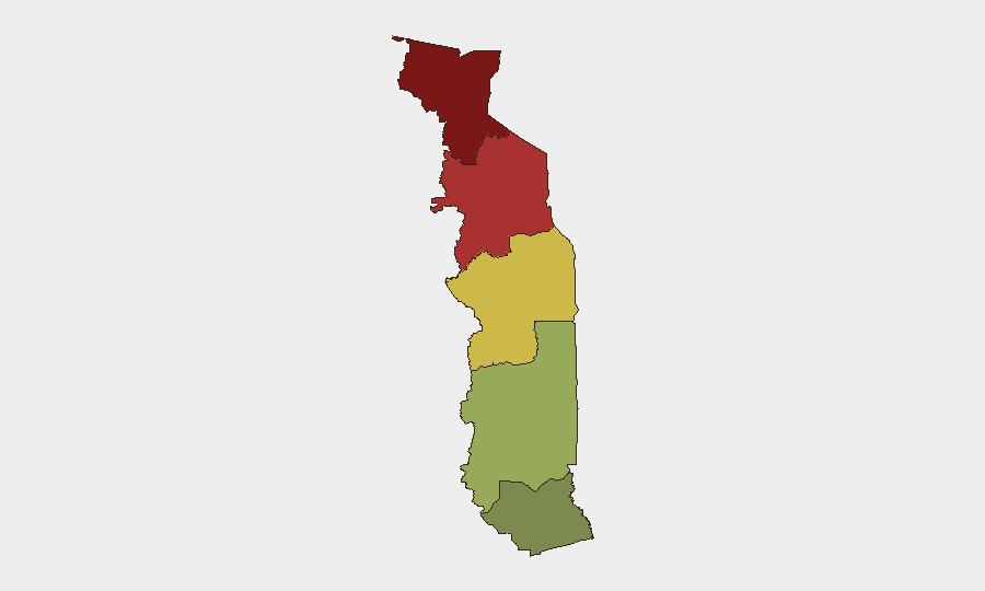
Togo remains a low-threat environment globally (rank #95; composite score 10) with no discrete security events recorded in the current tracking window. However, significant sub-national risk concentration exists in the northern Savanes and Kara regions, where cross-border instability from Burkina Faso and militant activity pose persistent challenges to stability. The Maritime Region and central zones remain comparatively stable, though northern areas warrant heightened vigilance and specialized monitoring.
Key Developments
No verified security, civil unrest, crime, political instability, infrastructure, or travel-risk incidents were confirmed in Togo during the last 24–48 hours. Current web research did not surface discrete events meeting brief criteria. Security teams should note that absence of reported incidents does not indicate absence of risk, particularly in the Savanes and Kara regions where operational awareness gaps are common and cross-border militia activity persists.
Highest-Risk Areas
The Savanes Region (risk score 92) and Kara Region (risk score 78) drive country-level threat concentration, primarily due to proximity to Burkina Faso's deteriorating security environment and the presence of militant networks operating across porous borders. The Centrale Region (score 65) faces secondary risk from spillover effects and trafficking corridors. By contrast, the Plateaux Region (45) and Maritime Region (28)—which includes the capital Lomé and primary commercial hub—present substantially lower direct threat profiles, though they remain subject to national-level political or economic shocks. Organizations with personnel or assets in Savanes or Kara should implement elevated operational security postures.
How GeoBit Would Assist
For Togo exposure, GeoBit's AOI Monitoring & Early Warning capability would establish persistent watches over Savanes and Kara regions to detect cross-border militia activity, displacement, or armed-group movement before they affect broader stability or international operations. OSINT fusion (X/Twitter, Telegram, local media, and multi-language feeds) combined with conflict & actor network analysis would provide early signals of political instability, trafficking escalation, or humanitarian crises. GIS & spatial analysis and satellite imagery would support route planning and real-time situational awareness for teams operating in or transiting through higher-risk northern zones.
7-Day Outlook
No imminent escalation is signaled in current data. However, seasonal and cross-border dynamics in the Sahel region warrant continuous monitoring; northern Togo's exposure to Burkina Faso instability remains the primary driver of medium-term risk. Security teams should maintain operational alertness and sustain intelligence collection on both formal political developments and non-state actor activity in border zones.
Highest-Risk Areas — Ranked
| # | State / Region | Risk |
|---|---|---|
| 1 | Savanes Region | 92 |
| 2 | Kara Region | 78 |
| 3 | Centrale Region | 65 |
| 4 | Plateaux Region | 45 |
| 5 | Maritime Region | 28 |
Sources
Previous Daily Briefs
A new Togo brief is written every day — each with its own risk map and downloadable CSV. Here's the last week; use the calendar to go further back.
📅 Browse every day by calendar →
Highlighted days have a brief. Tap a day for that day's map & analysis, or “csv” for that day's dataset ($5).
Atlas — our AI intelligence desk — emails them this snapshot personally. Nothing else, no list.