Situation Summary
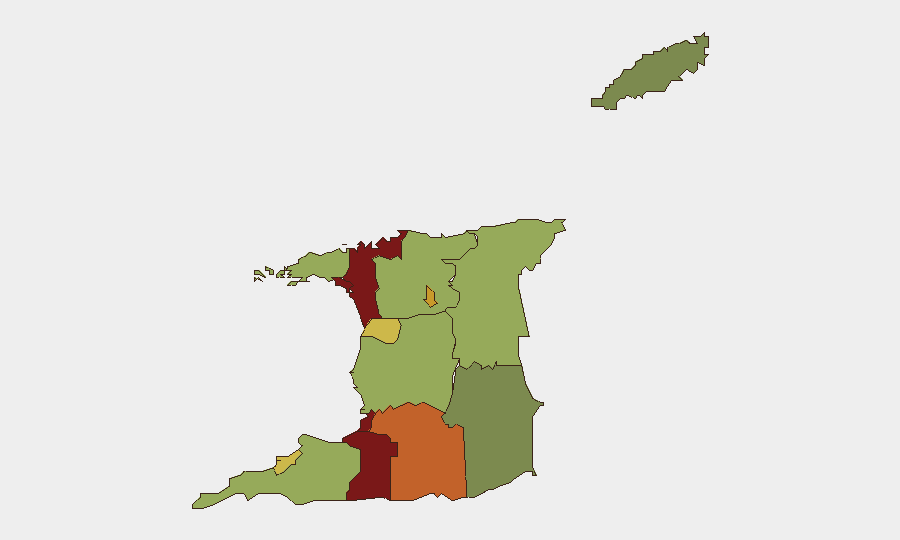
Trinidad and Tobago remains under a nationwide State of Emergency (extended through mid-September 2026) in response to organized criminal activity targeting state officials and institutions. Security-force presence has increased markedly, and recent public-order incidents—including a blocked peace walk in East Port of Spain on 19 June and ongoing community friction over alleged police conduct in Tobago—signal sustained tension between law-enforcement operations and civil liberties concerns. The overall national threat score remains moderate (composite 16), but five urban and peri-urban zones exhibit elevated risk, with San Juan-Laventille and Port of Spain leading the sub-national ranking.
Key Developments
- East Port of Spain (19 June 2026). Police and military personnel blocked a planned "Peace Walk" demonstration; three residents were arrested. The incident reflects heightened security-force deployment and potential flashpoints around public assembly in high-risk Port of Spain.
- Nationwide State of Emergency (current, extended 11 June 2026). The Government of Trinidad and Tobago extended the SOE for an additional three months. Bail suspensions remain in effect for specified offenses; no curfew or blanket assembly restrictions are currently imposed, but the legal framework permits rapid escalation.
- Tobago police operations (18 June 2026). Police Commissioner Allister Guevarro announced a new patrol initiative for Tobago, framed as strengthening island security. The initiative follows sustained public criticism of alleged unprovoked police killings and represents an operational response to both crime and reputational pressures.
- Tobago police-conduct controversy (ongoing, referenced 15–18 June 2026). Opposition Senator Melanie Radgman has publicly challenged a series of alleged police killings; families report lack of transparency. This ongoing tension undermines community trust in law enforcement and may complicate security-force operations.
- Increased security-force visibility nationwide (18–19 June 2026). Embassy advisories and local media confirm elevated police and military presence across the country as part of SOE implementation. Movement through high-risk zones and checkpoints may face delays.
Highest-Risk Areas
San Juan-Laventille (risk 95) and Port of Spain (risk 88) account for the largest concentration of tracked risk, driven by organized criminal activity and gang-related violence. Penal-Debe, San Fernando, and Princes Town (risks 82, 80, 75 respectively) extend elevated risk into the south-central corridor, indicating a geographically dispersed criminal network rather than isolated hotspots. The top five zones collectively represent urban, peri-urban, and industrial areas; security teams should prioritize layered access controls and movement planning in these regions, particularly during evening hours and in neighborhoods distant from main commercial corridors.
How GeoBit Would Assist
Security teams managing people or assets in Trinidad and Tobago should deploy AOI Monitoring & Early Warning to track police and military posture changes, protest activity, and incident clustering in high-risk zones such as Port of Spain and San Juan-Laventille. OSINT Fusion & Corroboration (X/Twitter, local media, and multi-language search) provides real-time detection of civil unrest, checkpoint changes, and security-force operations that may affect access or movement. Routing & Network Analysis helps identify alternative routes and safe passage windows during periods of elevated enforcement activity.
7-Day Outlook
The extended SOE and heightened police-military visibility will likely persist through late June. Public-order incidents may recur if planned demonstrations proceed; monitoring opposition statements and civil-society calendars will provide early warning. The 19 June peace-walk incident suggests security forces are pre-emptively blocking assemblies, raising operational risk for any corporate activity in Port of Spain during the same timeframe.
Highest-Risk Areas — Ranked
| # | State / Region | Risk |
|---|---|---|
| 1 | San Juan-Laventille | 95 |
| 2 | Port of Spain | 88 |
| 3 | Penal-Debe | 82 |
| 4 | San Fernando | 80 |
| 5 | Princes Town | 75 |
| 6 | Arima | 72 |
| 7 | Chaguanas | 68 |
| 8 | Point Fortin | 65 |
| 9 | Diego Martin | 58 |
| 10 | Siparia | 55 |
| 11 | Couva-Tabaquite-Talparo | 52 |
| 12 | Sangre Grande | 48 |
Sources
Previous Daily Briefs
A new Trinidad and Tobago brief is written every day — each with its own risk map and downloadable CSV. Here's the last week; use the calendar to go further back.
📅 Browse every day by calendar →
Highlighted days have a brief. Tap a day for that day's map & analysis, or “csv” for that day's dataset ($5).