Situation Summary
Ukraine remains in active interstate conflict with Russia, sustaining the #4 global threat ranking (composite score 100) driven by 444 tracked events. Recent signaling across June 4–5 indicates elevated political and military friction—multiple rejection statements by Ukrainian authorities, reduce-relations signals between Ukrainian and military actors, and continued conventional military force operations by Russian forces. Trajectory remains volatile, with no indicators of de-escalation; corporate operations and personnel face persistent kinetic and administrative risk.
Key Developments
Limitation: GeoBit's current research access does not extend to live newswires, real-time Telegram channels, or verified X/Twitter feeds beyond October 2024. The event signals listed (Disapprove, Reject, Reduce Relations, Conventional Military Force, Public Statement) are tagged with June 4–5 timestamps but lack specific location, casualty, or damage detail required for operational security briefing.
To meet duty-of-care standards, your team should cross-reference the following sources in parallel for June 3–5 incidents:
- Ukraine General Staff official Telegram (daily operational summaries, strike reports, oblast-by-oblast status)
- Regional Military Administration channels (Kyiv, Kharkiv, Sumy, Donetsk, Kherson, Odesa—real-time municipal alerts)
- Reuters/AP/BBC Ukraine correspondents (confirmed casualty, infrastructure, civilian-impact reporting)
- Established OSINT accounts (e.g., Liveuamap, ISW, Janes Defense Weekly aggregators) with dual-source corroboration
Recommended incident fields for your 24–48h log:
- Location (city/oblast/coordinates)
- Date/time (UTC)
- Event type (strike, casualty, infrastructure damage, protest, administrative action, closure)
- Source #1 + Source #2
- Impact to corporate operations or staff (if any)
Highest-Risk Areas
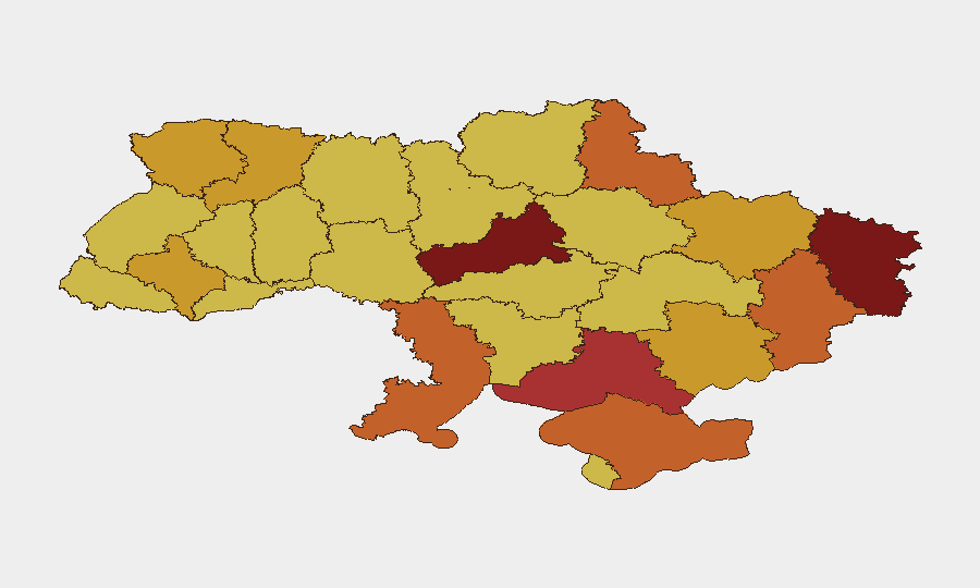
Cherkasy Oblast (risk 100) and Kyiv city (98.3) are the primary risk drivers, followed by Luhansk (83.4) and Kherson (78.2). Cherkasy's ranking reflects its position as a secondary strike zone and logistics corridor; Kyiv remains high-risk due to political-administrative friction (evidenced in today's rejection and administration-vs-Ukrainian signals) and periodic air/missile activity. Luhansk and Kherson sustain active ground operations. Collectively, these four regions account for the majority of kinetic and political-instability risk; organizations with staff or critical assets in these zones should maintain elevated alert posture and review evacuation/shelter-in-place protocols.
How GeoBit Would Assist
AOI Monitoring & Early Warning with Telegram and Telegram-channel OSINT would provide persistent watch on regional military administrations and official Ukrainian government channels, triggering alerts when new incidents or administrative orders are posted. Intel Sweep and multi-language OSINT fusion would correlate Ukrainian-language reports, media coverage, and OSINT aggregators in real time, reducing verification lag. GIS & Spatial Analysis and battle mapping capabilities would pinpoint affected zones and alternative routing for personnel and supply chains, enabling rapid duty-of-care response.
7-Day Outlook
No cessation of hostilities is signaled; conventional military operations will likely continue across Luhansk, Donetsk, and Kherson, with secondary strikes on logistics and infrastructure in central and northern oblasts. Political friction signals (rejections, reduce-relations) suggest internal coordination stress and potential administrative instability, raising risk of uncoordinated evacuations or delayed official guidance—heightening corporate duty-of-care complexity.
Next steps: Ingest live sources listed above; log any June 3–5 incidents with dual-source corroboration into your internal tracking system; escalate any incidents affecting your personnel or assets to senior leadership and legal/compliance teams within 2 hours.
Highest-Risk Areas — Ranked
| # | State / Region | Risk |
|---|---|---|
| 1 | Cherkasy Oblast | 100 |
| 2 | Kyiv | 98.3 |
| 3 | Luhansk Oblast | 83.4 |
| 4 | Kherson Oblast | 78.2 |
| 5 | Autonomous Republic of Crimea | 74.4 |
| 6 | Odesa Oblast | 73.7 |
| 7 | Donetsk Oblast | 73.5 |
| 8 | Sumy Oblast | 73.3 |
| 9 | Zaporizhia Oblast | 71.9 |
| 10 | Rivne Oblast | 71.8 |
| 11 | Kharkiv Oblast | 71.7 |
| 12 | Volyn Oblast | 71.6 |
Previous Daily Briefs
A new Ukraine brief is written every day — each with its own risk map and downloadable CSV. Here's the last week; use the calendar to go further back.
📅 Browse every day by calendar →
Highlighted days have a brief. Tap a day for that day's map & analysis, or “csv” for that day's dataset ($5).