Situation Summary
Yemen remains locked in active civil conflict with an escalating regional dimension. Over the past 24–48 hours, Israeli airstrikes on Houthi positions in Sana'a have followed a ballistic missile volley launched by Houthi forces toward Israel, signaling renewed cross-border military activity. Concurrently, the Houthis have restated their ban on Israeli maritime transit through the Red Sea and Bab al-Mandab, creating dual risks: air/ground kinetic activity in northern Yemen and potential disruption to critical shipping corridors. Diplomatic engagement continues at the UN level, but no de-escalation breakthrough has been announced, and the trajectory remains volatile.
Key Developments
- Sana'a, 2026-06-14: Israeli aircraft conducted airstrikes on Houthi targets in and around Yemen's capital following reported Houthi missile launches toward Israel; no independently verified casualty or damage figures released to date.
- Yemen–Israel axis, 2026-06-14: Houthi/Ansar Allah media channels announced a ballistic missile barrage directed at Israel; Israeli military confirmed detection and interception of at least one incoming missile the same day.
- Red Sea / Bab al-Mandab, 2026-06-14: Houthi officials reiterated a formal ban on Israeli-flagged and Israeli-linked vessels transiting the strategic waterway, tying the declaration to Sunday's escalation; maritime-risk analysts have flagged heightened caution but no fresh interdictions of commercial traffic have been confirmed in the last 48 hours.
- Saudi–Yemen border, 2026-06-14: Saudi Arabia's Ministry of Defense reported that a ballistic missile launched from Yemen landed in an unpopulated area near the border; the incident is linked to the same Houthi launch series and caused no reported casualties.
- Regional rhetoric, 2026-06-14: Iranian Quds Force commander Esmail Qaani publicly referenced a new "security belt" extending from the Strait of Hormuz to Bab al-Mandab, with explicit language about potential closure or disruption if regional conflict persists; shipping and energy analysts are flagging elevated strategic risk to Red Sea and Gulf maritime traffic as a result.
- Diplomatic track, 2026-06-14–ongoing: UN-led talks between Yemeni parties and regional states continue in Geneva and regional venues, focusing on ceasefire and maritime-security frameworks; no new binding agreements or enforcement mechanisms have been announced.
- Travel advisories, 2026-06-14: Multiple government and private risk-advisory updates reconfirm Yemen at "Do Not Travel" status, with specific warnings for Sana'a, Sa'dah, Al Hudaydah, and Saudi border governorates due to airstrikes and cross-border fire.
Highest-Risk Areas
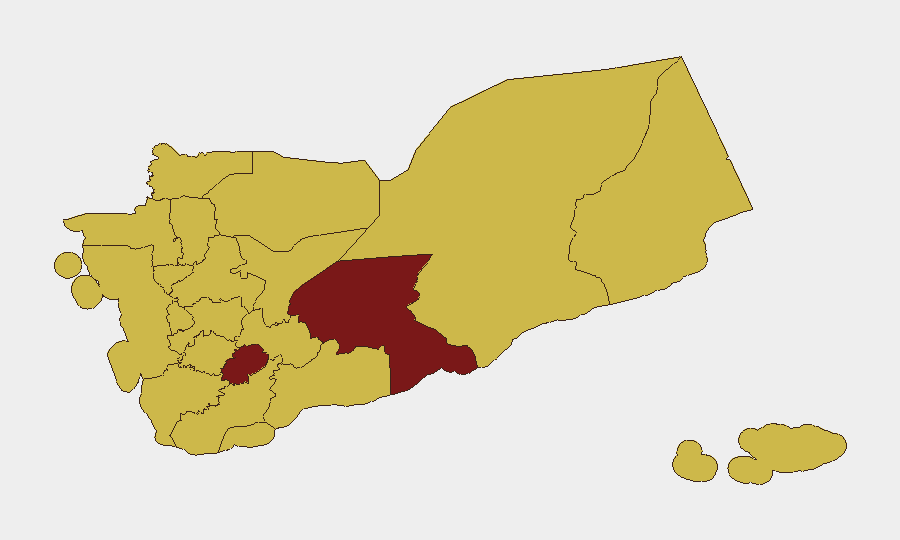
Shabwah Governorate ranks as the single highest-risk sub-national zone (score 100), driven by territorial control disputes and weapons-trafficking networks in a remote, ungoverned area. Ad Dali' Governorate (85) follows, reflecting proximity to active conflict zones and shifting military control. Ten governorates, including Sa'dah, Al Hudaydah, Sana'a, and 'Amran, all score 70 and concentrate northern Yemen's conflict intensity: these are the epicenters of Houthi operations, Israeli and Saudi air activity, and cross-border fire, making them unsuitable for non-essential personnel and high-risk for asset security.
How GeoBit Would Assist
Security teams should deploy AOI Monitoring & Early Warning on Sana'a and Red Sea maritime zones to track imminent airstrikes and missile activity with sub-24-hour alerting. Conflict & Military battle-mapping and force-structure analysis provides real-time clarity on Houthi deployment, Israeli operational patterns, and Saudi posture. Maritime & Aviation tracking, paired with Routing & Network Analysis, enables duty-of-care teams to identify safe maritime transit corridors and alternative supply-chain pathways around Red Sea disruption risk.
7-Day Outlook
Tit-for-tat military escalation between Israeli and Houthi forces is likely to persist through the next week, with further airstrikes and missile launches probable if either side perceives tactical advantage. Red Sea maritime risk will remain elevated, though closure has not yet materialized; shipping insurers and operators should assume intermittent disruption and interdiction risk rather than full blockade. Diplomatic talks may yield procedural progress but are unlikely to reverse the current kinetic trajectory absent a major external intervention or political shift by one of the main parties.
Highest-Risk Areas — Ranked
| # | State / Region | Risk |
|---|---|---|
| 1 | Shabwah Governorate | 100 |
| 2 | Ad Dali' Governorate | 85 |
| 3 | Sa'dah Governorate | 70 |
| 4 | Hajjah Governorate | 70 |
| 5 | Al Mahwit Governorate | 70 |
| 6 | Al Hudaydah Governorate | 70 |
| 7 | 'Amran Governorate | 70 |
| 8 | Amanat Al Asimah | 70 |
| 9 | Sana'a Governorate | 70 |
| 10 | Raymah Governorate | 70 |
| 11 | Dhamar Governorate | 70 |
| 12 | Ibb Governorate | 70 |
Sources
Previous Daily Briefs
A new Yemen brief is written every day — each with its own risk map and downloadable CSV. Here's the last week; use the calendar to go further back.
📅 Browse every day by calendar →
Highlighted days have a brief. Tap a day for that day's map & analysis, or “csv” for that day's dataset ($5).