Situation Summary
Moldova faces escalating diplomatic and political tensions with Russia following alleged police actions against Russian embassy staff in Chișinău and at border crossings, which prompted a formal Russian protest on July 21. Concurrently, Moldova is accelerating EU alignment through defense modernization (€120 million EU air-defense package approved this week) and enforcement of sanctions compliance, signaling a deliberate pivot toward Western security architecture. The sub-national risk geography remains heavily weighted toward territories east of the Dniester River and southern border regions, where Russian influence, frozen-conflict dynamics, and cross-border activity create persistent instability. Overall national threat remains moderate, but trajectory is one of increasing state-level friction with Russia paired with institutional strengthening.
Key Developments
- Russian diplomatic protest (July 21): Russia's Foreign Ministry summoned Moldovan Ambassador Lilian Darii to lodge formal complaints over alleged "force and threats of detention" by Moldovan police against Russian embassy staff in Chișinău and incidents involving document checks and delays at a Moldovan border crossing. Moscow warned of possible retaliatory measures.
- EU €120 million air-defense package approved (July 21–22): The Council of the European Union approved a major assistance package dedicated to strengthening Moldova's air-defense infrastructure, reflecting accelerated security cooperation and investment in airspace protection.
- Moldovan Defense Ministry procurement (July 21–22): Moldova's Defense Ministry announced acquisition of new detection systems and drone-interceptor capabilities, funded by the European Union, signaling active air-defense modernization.
- Parliamentary defense alignment (July 21–22): Moldova's parliament speaker called publicly for increased defense investment and full alignment with EU sanctions against Russia, positioning Moldova's security posture explicitly within the Western institutional framework.
- MFA travel advisory (July 21–22): Moldova's Ministry of Foreign Affairs advised Moldovan citizens to refrain from travel to Russia and Belarus, reflecting deteriorating perceived security conditions and political relations.
- Russian Center closure (July 21–22): The Russian House (Center for Science and Culture) in Chișinău announced termination of operations following a Moldovan government decision, reducing Russian institutional presence in the capital.
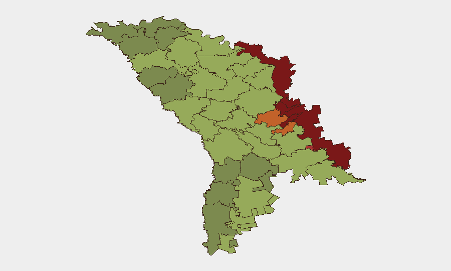
Highest-Risk Areas
The Left Bank Dniester territories (risk 85) and Dubăsari (risk 82) dominate the risk ranking, driven by unresolved frozen-conflict status, Russian military presence, weak Moldovan state authority, and cross-border infiltration vectors. Bender (79) and Criuleni (75) follow, reflecting proximity to Russian-aligned breakaway structures and border vulnerability. Southern border districts (Taraclia, Ștefan Vodă) rank elevated due to cross-border smuggling, weapons trafficking, and organized-crime networks. Chișinău itself (49) remains the least-ranked major location, but diplomatic incidents this week suggest heightened Russian targeting of government and embassy operations in the capital, warranting attention despite the numerical score.
How GeoBit Would Assist
Security teams operating in Moldova should deploy AOI Monitoring & Early Warning on high-risk districts (Left Bank, Bender, southern border) to detect movement patterns, security-force deployments, and cross-border activity; Intel Sweep and multi-language OSINT (Telegram, local media) to track Russian diplomatic and military signaling; and Network & Actor Analysis to map Russian intelligence, proxy, and organized-crime networks active in frozen-conflict zones and border regions. Real-time sentiment & temporal analysis on Moldova-Russia political rhetoric will provide early indicators of escalation or de-escalation.
7-Day Outlook
Russian-Moldovan diplomatic friction is likely to remain elevated through at least the next week, with Moscow potentially imposing reciprocal restrictions on Moldovan diplomatic or consular operations. EU defense assistance flows will accelerate, but implementation timelines for air-defense systems remain measured. No immediate large-scale security incidents are forecast, but localized tensions at border crossings and in breakaway-controlled territories should be expected to persist or spike in response to Chișinău's intensified sanctions enforcement and NATO alignment rhetoric.
Highest-Risk Areas — Ranked
| # | State / Region | Risk |
|---|---|---|
| 1 | Administrative-Territorial Units of the Left Bank of the Dniester | 85 |
| 2 | Dubăsari | 82 |
| 3 | Bender | 79 |
| 4 | Criuleni | 75 |
| 5 | Rezina | 58 |
| 6 | Taraclia | 55 |
| 7 | Gagauzia | 54 |
| 8 | Căușeni | 53 |
| 9 | Soroca | 52 |
| 10 | Ștefan Vodă | 51 |
| 11 | Orhei | 50 |
| 12 | Chișinău | 49 |
Sources
Previous Daily Briefs
A new Moldova brief is written every day — each with its own risk map and downloadable CSV. Here's the last week; use the calendar to go further back.
📅 Browse every day by calendar →
Highlighted days have a brief. Tap a day for that day's map & analysis, or “csv” for that day's dataset ($5).
Atlas — our AI intelligence desk — emails them this snapshot personally. Nothing else, no list.