Situation Summary
Afghanistan remains the 33rd highest-threat country globally, with insurgency as the primary driver of risk. Recent signals point to escalating political friction, cross-border military activity involving Pakistan, and isolated but significant security incidents targeting journalists and state officials. The overall security environment is fragmented by sub-national variation, with central and southern provinces experiencing substantially higher threat concentrations than northern and western areas.
Key Developments
- Kabul Province – 10 June 2026 – Journalist abducted by Taliban operatives; circumstances and current status remain unclear pending independent corroboration.
- Cross-Border – 11 June 2026 – Two reported conventional military engagements between Pakistani and Afghan forces; scope and casualties unconfirmed.
- Kabul – 10 June 2026 – Armed confrontation between authorities and protesters involving small-arms fire; civilian and security force presence in tension.
- National Political Level – 9–10 June 2026 – Public statements by Afghan politicians, UN Security Council, and international lawyers reflecting diplomatic discord over governance and accountability; legal/political friction rather than immediate kinetic threat, but indicative of institutional strain.
- Administrative/Prosecutorial – 11 June 2026 – Reported unconventional violence incident involving prosecutor and military personnel; details insufficient for risk assessment without corroboration.
*Note:* Web research did not identify additional independently corroborated incidents with specific timestamps in the 10–11 June window. The above reflects event signals from GeoBit's tracked feed; further sourcing via regional news wires and verified local media recommended to confirm casualty figures, locations, and ongoing threat.
Highest-Risk Areas
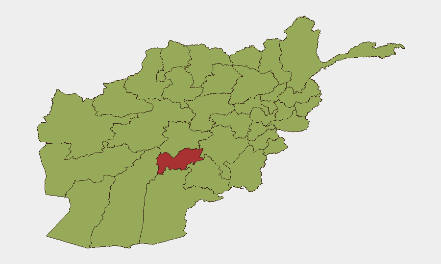
Uruzgan Province dominates the sub-national ranking at 76.9, reflecting sustained insurgent activity and minimal state control. Daykundi and Khost (both 53.4) follow, with Kabul Province (52.6) notably elevated despite its capital status—signaling that administrative centers are no longer exempted from violence. The southern and eastern cluster—Uruzgan, Kandahar, Helmand, Zabul, and Paktika—represents the persistent Taliban heartland and source of conventional and asymmetric threats. Herat, Farah, and Nimruz in the west and southwest are also ranked in the high-46 range, suggesting cross-border spillover from Iranian instability and Baloch militancy. Organizations with personnel or assets in Uruzgan, Khost, or Kandahar face materially higher threat exposure than those in northern provinces.
How GeoBit Would Assist
OSINT Fusion & Multi-Source Corroboration: Cross-reference regional news wires, verified social media (X/Twitter via date-filtered geo-keywords), UNAMA and OCHA feeds, and embassy alerts to build a continuous, time-stamped incident log—essential for separating current events from recirculated or misdated reports.
AOI Monitoring & Early Warning: Persistent geospatial watches on Uruzgan, Khost, and Kabul provinces with automated alert triggers for military activity, attacks, or checkpoint disruptions provide advance notice of escalation.
Conflict & Battle Mapping, Force Structure Tracking: Monitor Pakistani cross-border movements and Taliban/ISIS-K conventional capabilities to anticipate regional flashpoints and inform travel routing.
7-Day Outlook
Political and diplomatic friction is likely to persist, with incremental risk of further street-level protests in Kabul. Cross-border Pakistani-Afghan military clashes may recur along the Durand Line, though neither side appears to be pursuing sustained conventional engagement. Insurgent activity in the south and east will remain the primary kinetic driver; no indication of imminent nationwide escalation, but localized attacks in high-risk provinces should be expected as routine.
Highest-Risk Areas — Ranked
| # | State / Region | Risk |
|---|---|---|
| 1 | Uruzgan Province | 76.9 |
| 2 | Daykundi Province | 53.4 |
| 3 | Khost Province | 53.4 |
| 4 | Kabul Province | 52.6 |
| 5 | Paktika Province | 50.7 |
| 6 | Herat Province | 47.2 |
| 7 | Zabul Province | 46.9 |
| 8 | Kandahar Province | 46.9 |
| 9 | Ghazni Province | 46.9 |
| 10 | Farah Province | 46.9 |
| 11 | Nimruz Province | 46.9 |
| 12 | Helmand Province | 46.9 |
Sources
Previous Daily Briefs
A new Afghanistan brief is written every day — each with its own risk map and downloadable CSV. Here's the last week; use the calendar to go further back.
📅 Browse every day by calendar →
Highlighted days have a brief. Tap a day for that day's map & analysis, or “csv” for that day's dataset ($5).