Situation Summary
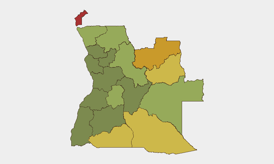
Angola remains a stable, lower-threat environment regionally, ranked #48 globally with a composite threat score of 48. Current security conditions do not reflect active armed conflict, widespread civil unrest, or major incidents in the national capital or primary economic zones. The primary hazard signal in recent monitoring is environmental—widespread wildfires across multiple provinces—rather than political violence or armed group activity. Overall trajectory is stable with localized environmental risk.
Key Developments
- Wildfire activity across central and eastern Angola (past 7 days): Multiple confirmed wildfire events detected in Angola, with cross-border fire activity also reported between Angola and the Democratic Republic of Congo. Specific event identifiers include incidents 1028991, 1028906, 1028920, 1028964, and others concentrated in June 2026. Geographic spread suggests dry-season fire risk across Cabinda, Lunda Norte, Lunda Sul, and Moxico provinces.
- No confirmed civil unrest, armed incidents, or major security events (last 24–48 hours): Open-source search and web monitoring identified no credible, time-stamped reports of political violence, terrorist activity, infrastructure disruption, or travel-affecting incidents in Angola within the reporting window. Standard baseline security conditions persist.
Highest-Risk Areas
Cabinda Province (risk 78), Lunda Norte (72), and Lunda Sul (68) dominate Angola's sub-national threat landscape. These three northeastern and eastern provinces—historically affected by separatist tensions, artisanal and illegal mining activity, and weak state presence—remain structurally higher-risk than the rest of the country. Cuando Cubango, Cunene, and Moxico provinces (risk 64–58) form a secondary tier of concern along southern and southeastern borders, where cross-border movement, resource smuggling, and remote terrain complicate oversight. Central and western provinces (Huambo, Uíge, Malanje, and especially Huíla and Bié) show materially lower risk scores, reflecting stronger state control and lower incidence of organized armed activity.
How GeoBit Would Assist
Security and risk teams with personnel or assets in Angola should employ Area-of-Interest (AOI) Monitoring & Early Warning on Cabinda and the Lunda provinces to detect emerging unrest or armed group movement before operational impact; OSINT Fusion & Corroboration (X/Twitter, Telegram, radio SIGINT) to triangulate mining-zone instability and cross-border actor movements; and Satellite & Imagery Analysis to track infrastructure, route security, and wildfire impact on access roads and supply chains. GIS & Spatial Analysis supports alternative routing around high-risk zones and incident clusters.
7-Day Outlook
Environmental hazards (wildfire) will likely persist into July given seasonal conditions in central Angola. No intelligence signals suggest imminent escalation of armed conflict or organized unrest in the coming week. Baseline operational security measures in Cabinda and the Lundas remain prudent; teams in lower-risk provinces face standard urban and petty-crime risk typical of Angola's main urban centers.
Highest-Risk Areas — Ranked
| # | State / Region | Risk |
|---|---|---|
| 1 | Cabinda Province | 78 |
| 2 | Lunda Norte Province | 72 |
| 3 | Lunda Sul Province | 68 |
| 4 | Cuando Cubango Province | 64 |
| 5 | Cunene Province | 62 |
| 6 | Moxico Province | 58 |
| 7 | Zaire Province | 54 |
| 8 | Huambo Province | 50 |
| 9 | Uíge Province | 48 |
| 10 | Malanje Province | 42 |
| 11 | Bié Province | 35 |
| 12 | Huíla Province | 32 |
Sources
Previous Daily Briefs
A new Angola brief is written every day — each with its own risk map and downloadable CSV. Here's the last week; use the calendar to go further back.
📅 Browse every day by calendar →
Highlighted days have a brief. Tap a day for that day's map & analysis, or “csv” for that day's dataset ($5).