Situation Summary
The Bahamas remains a low-threat environment globally (rank #79, composite score 16) with no tracked major organized incidents, but localized crime—particularly armed robbery and gang-related violence—concentrates risk sharply in New Providence and Freeport. The last 24–48 hours have seen two fatal incidents in Nassau requiring armed police response, reflecting the baseline pattern of interpersonal and street-level violence that defines the threat landscape rather than any escalation of systemic instability. Inter-island aviation remains degraded following the 10 July Flamingo Air crash, which continues to affect transport reliability and operational planning. No evidence of civil unrest, political instability, or major infrastructure failure exists in the current window.
Key Developments
- Nassau, Carmichael Road near Spikenard Road (2026-07-19) — A 59-year-old male fatally struck by vehicle in apparent hit-and-run; police engaged suspects in gunfire exchange, one suspect shot and arrested during pursuit.
- Nassau, Father Callen Road off Market Street (2026-07-16) — Male in his 30s shot dead by two armed suspects on a moped; investigation ongoing, classified as street-level homicide.
- Broader Nassau/New Providence — Two fatal violent incidents within 72 hours reflect recurring pattern of armed crime in the capital; no indication of organized gang conflict escalation or territorial shift based on available reporting.
- Inter-island aviation — Flamingo Air Cessna 402 crash (10 July, near San Andros Airport, 10 fatalities) continues to constrain regional mobility and logistics; replacement capacity has not been fully restored.
- No major new civil, political, or infrastructure events detected in 24–48 hour window; event signal feeds show routine government activity and international statement traffic but no crisis indicators.
Highest-Risk Areas
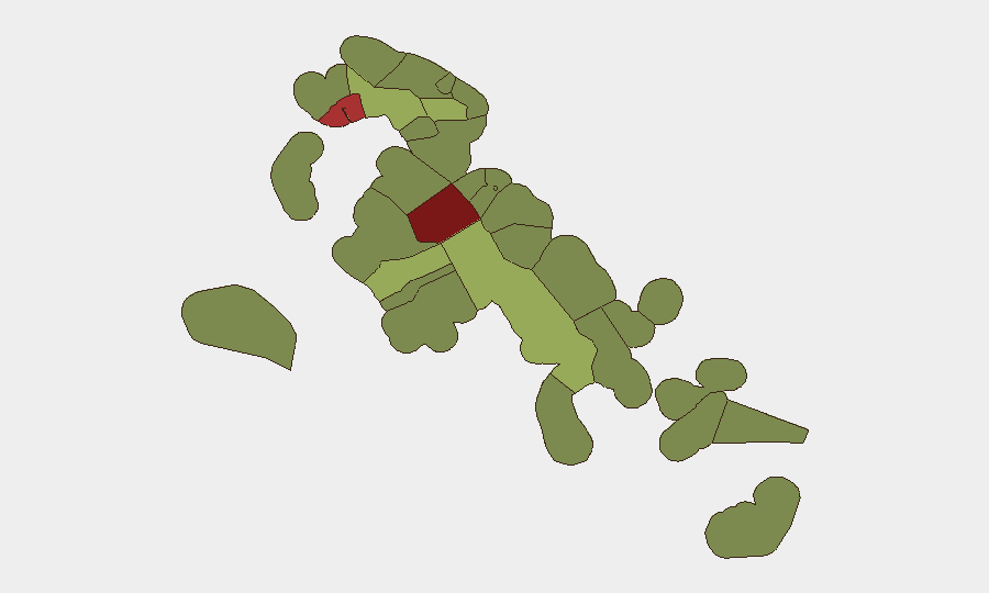
New Providence (risk 92) and City of Freeport (risk 78) account for the overwhelming majority of tracked threat activity, driven by street-level armed robbery, gang-affiliated homicides, and trafficking-related violence. New Providence—which contains Nassau and the national capital—is the primary focal point; Freeport's elevated score reflects similar dynamics in a smaller, more geographically concentrated setting. Remaining ranked islands (Central Abaco through Mangrove Cay, risks 52–28) show materially lower but non-negligible exposure, typically tied to inter-island trafficking corridors and lower policing density. Organizations with personnel or assets outside the two primary urban centers face significantly reduced risk from violence, though maritime and aviation incidents remain inherent to the region.
How GeoBit Would Assist
Security teams operating in Bahamas should employ Intel Sweep and X/Telegram OSINT to maintain real-time awareness of street-level incidents in New Providence and Freeport, coupled with sentiment and temporal analysis to detect early signs of gang activity escalation or trafficking route shifts. AOI Monitoring & Early Warning configured for Nassau and Freeport precincts would provide persistent alerting on police activity, roadblocks, and incident clustering that might signal emerging hotspots. Maritime & Aviation tracking is critical given ongoing inter-island transport fragility and the narcotics transit risk along shipping lanes and small-aircraft corridors.
7-Day Outlook
No major destabilizing events are forecast; the security picture over the next seven days should remain consistent with baseline crime patterns centered on Nassau and Freeport. Continue monitoring aviation sector recovery and any resumption of service disruptions. Personnel movement and asset placement decisions should remain weighted toward the sub-national risk geography, with heightened caution in New Providence and elevated situational awareness in transit corridors.
Highest-Risk Areas — Ranked
| # | State / Region | Risk |
|---|---|---|
| 1 | New Providence | 92 |
| 2 | City of Freeport | 78 |
| 3 | Central Abaco | 52 |
| 4 | Central Andros | 48 |
| 5 | Exuma | 45 |
| 6 | East Grand Bahama | 42 |
| 7 | South Andros | 38 |
| 8 | North Abaco | 35 |
| 9 | North Eleuthera | 33 |
| 10 | South Abaco | 32 |
| 11 | Cat Island | 30 |
| 12 | Mangrove Cay | 28 |
Sources
Previous Daily Briefs
A new Bahamas brief is written every day — each with its own risk map and downloadable CSV. Here's the last week; use the calendar to go further back.
📅 Browse every day by calendar →
Highlighted days have a brief. Tap a day for that day's map & analysis, or “csv” for that day's dataset ($5).
Atlas — our AI intelligence desk — emails them this snapshot personally. Nothing else, no list.