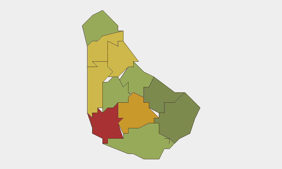
Situation Summary
Barbados remains a low-threat environment globally (rank #74, composite score 14) with no corroborated security incidents, civil unrest, infrastructure disruptions, or acute threats detected in the last 24–48 hours. Three event signals were logged on 2026-07-24—an "Occupy Territory" community action, a public statement between Jamaica and Barbados, and domestic disapproval sentiment—but open-source monitoring has not yet surfaced verified details or operational impact. The security posture remains stable, though Saint Michael and Saint George parishes continue to register elevated risk scores warranting focused monitoring.
Key Developments
- 2026-07-24 · Community Occupy Action — A "Occupy Territory" community action was flagged on 2026-07-24; no location, participants, or specific impact confirmed in available sources.
- 2026-07-24 · Jamaica–Barbados Public Statement — A public statement involving Jamaica and Barbados was logged on 2026-07-24; full content and context not yet clarified in corroborated reporting.
- 2026-07-24 · Domestic Disapproval Signal — Domestic disapproval sentiment was detected on 2026-07-24; scope and subject not yet specified in available intelligence.
- Brighton, St George · Migrant Housing Conditions — Overcrowded and unsanitary conditions were reported at a government-contracted migrant worker housing site in Brighton, St George; timing and acute risk impact not yet confirmed.
- Silver Hill, Christ Church · Police Tag Reference — A shooting incident was referenced in police records for Silver Hill, Christ Church; specific date and details not confirmed in supplied results.
- Continued Stability Across Island — No observable unrest, disruptions, or acute threats were identified in the wider island network as of 19 July 2026.
Highest-Risk Areas
Saint Michael (risk 78) and Saint George (risk 72) are the primary risk drivers, followed by Saint James (68) and Saint Andrew (65). These four parishes account for the elevated sub-national risk profile and warrant prioritized monitoring and duty-of-care review for corporate personnel and assets. The Brighton migrant housing concern in Saint George and the unconfirmed Silver Hill incident in Christ Church suggest localized community friction and sporadic crime activity; however, neither has been confirmed as an immediate threat to business operations or expat populations. Southern parishes (Saint Philip, Saint John, Christ Church) show significantly lower risk scores and remain stable.
How GeoBit Would Assist
A security team protecting people or assets in Barbados would use Intel Sweep and global event feeds to track the three 2026-07-24 signals to resolution; X/Twitter and Telegram OSINT to monitor sentiment, community mobilization, and official announcements in real time; and AOI Monitoring & Early Warning with persistent watch on Saint Michael, Saint George, Saint James, and high-activity parishes to detect emerging unrest or crime patterns before escalation. Sentiment & temporal analysis would clarify the disapproval signal and assess whether the Jamaica–Barbados statement carries destabilizing weight. GIS & Spatial Analysis and routing tools would support contingency planning and alternative movement for personnel in high-risk parishes.
7-Day Outlook
No imminent acute threat is forecast. The three 2026-07-24 event signals should clarify over the next 48–72 hours; if they resolve to routine community or diplomatic matters, the risk profile will remain static. Monitoring of Saint Michael and Saint George should continue to detect any uptick in crime or civil friction, particularly if the Jamaica–Barbados statement escalates to regulatory or trade action affecting business continuity.
Highest-Risk Areas — Ranked
| # | State / Region | Risk |
|---|---|---|
| 1 | Saint Michael | 78 |
| 2 | Saint George | 72 |
| 3 | Saint James | 68 |
| 4 | Saint Andrew | 65 |
| 5 | Saint Peter | 62 |
| 6 | Saint Joseph | 58 |
| 7 | Saint Thomas | 52 |
| 8 | Saint Lucy | 48 |
| 9 | Christ Church | 42 |
| 10 | Saint John | 35 |
| 11 | Saint Philip | 28 |
Sources
Previous Daily Briefs
A new Barbados brief is written every day — each with its own risk map and downloadable CSV. Here's the last week; use the calendar to go further back.
📅 Browse every day by calendar →
Highlighted days have a brief. Tap a day for that day's map & analysis, or “csv” for that day's dataset ($5).
Atlas — our AI intelligence desk — emails them this snapshot personally. Nothing else, no list.