Situation Summary
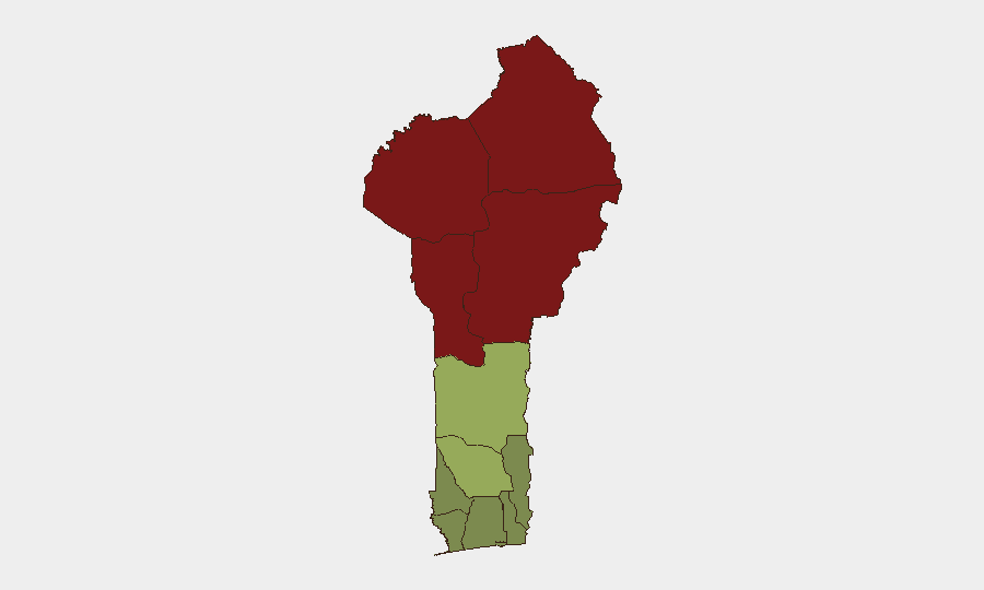
Benin's composite threat score of 33 places it in the lower-to-moderate range globally, but sub-national risk is highly concentrated in the northern border regions. Recent signals indicate domestic political tension alongside military disapproval statements, coupled with public order incidents. The north—particularly Alibori, Atakora, Donga, and Borgou departments—remains the primary driver of risk, likely linked to cross-border militant activity and resource competition rather than systemic state collapse.
Key Developments
- 2026-06-22 · Public Statement (Benin, domestic). Details unavailable; likely administrative or policy-level communication unrelated to acute security incidents.
- 2026-06-21 · Violent Protest/Riot (Benin, location unspecified). A public-order event was recorded; specific location, trigger, and casualty count remain unconfirmed in available reporting.
- 2026-06-21 · Military Disapproval (Military vs. Benin, location unspecified). Two recorded disapproval statements from military actors suggest institutional tension or criticism of government policy; no indication of active mutiny or armed standoff as of reporting.
- 2026-06-21 · Diplomatic Disapproval (Benin vs. Niger). A formal disapproval statement reflects bilateral tension; likely tied to border management, resource allocation, or cross-border movement of armed groups.
Note: GeoBit's event signal feed has captured six events in the tracking window, but precise incident locations, casualty figures, and direct security implications for corporate assets remain undetailed in the current data snapshot. A real-time OSINT sweep (news, X/Twitter, NGO alerts) would be required to isolate specific robbery, kidnapping, or militant attack events in the past 48 hours.
Highest-Risk Areas
Northern departments dominate the risk profile. Alibori (92), Atakora (88), Donga (85), and Borgou (83) account for the concentration of threat; these regions border Niger and face recurring cross-border militant infiltration, trafficking networks, and communal resource conflict. The southern and coastal departments—Ouémé, Littoral, Atlantique—remain comparatively stable (risk scores 22–28), making Cotonou and Port-Novo operationally lower-risk for routine corporate activity. The jump from Zou (45) down to Collines (42) suggests a clear security inflection between the central and northern zones.
How GeoBit Would Assist
Security and duty-of-care teams should deploy AOI Monitoring & Early Warning on Alibori and Atakora departments to detect emerging militant activity, roadblocks, or protest escalation in real time. Conflict & Military intelligence and Network & Actor Analysis would clarify the military institutional tension signaled on 2026-06-21 and identify which actors or factions are involved. Routing & Network Analysis enables alternative journey planning for personnel or supply movements in the north, bypassing high-risk corridors identified through OSINT fusion of local media, X/Twitter, and NGO field reports.
7-Day Outlook
Northern border tension and military-civilian friction are likely to persist through the coming week; no indicators suggest rapid de-escalation. Corporate teams with assets or personnel in Alibori, Atakora, or Donga should maintain heightened situational awareness and consider restricting non-essential travel to those zones. Southern and coastal regions remain lower-risk; routine operations in Cotonou and the Littoral are not expected to be materially disrupted absent significant political shock.
Highest-Risk Areas — Ranked
| # | State / Region | Risk |
|---|---|---|
| 1 | Alibori Department | 92 |
| 2 | Atakora Department | 88 |
| 3 | Donga Department | 85 |
| 4 | Borgou Department | 83 |
| 5 | Zou Department | 45 |
| 6 | Collines Department | 42 |
| 7 | Plateau Department | 38 |
| 8 | Kouffo Department | 35 |
| 9 | Mono Department | 32 |
| 10 | Atlantique Department | 28 |
| 11 | Littoral | 25 |
| 12 | Ouémé Department | 22 |
Sources
Previous Daily Briefs
A new Benin brief is written every day — each with its own risk map and downloadable CSV. Here's the last week; use the calendar to go further back.
📅 Browse every day by calendar →
Highlighted days have a brief. Tap a day for that day's map & analysis, or “csv” for that day's dataset ($5).