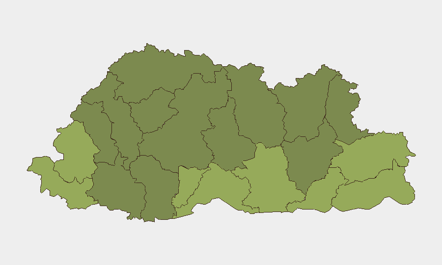
Situation Summary
Bhutan remains one of the world's lowest-threat environments, with a composite threat score of 2 and no credible security incidents reported in the last 24–48 hours. The country's stability trajectory is flat; routine governance, development activity, and tourism operations continue without disruption. One tracked event from 2026-06-21 is under investigation but has not yet surfaced in widely accessible open sources or triggered alerts from international travel or diplomatic channels.
Key Developments
- Bhutan (nationwide) – 2026-06-21 – One event under investigation: A single signal has been logged in GeoBit's event tracking system dated 2026-06-21. Details remain limited pending corroboration; no confirmation has emerged in mainstream news, diplomatic advisories, or international security feeds as of 2026-06-22 morning.
- No reported civil unrest or armed conflict – Last 24–48 hours: Global event feeds, regional risk platforms, and news aggregators tracking terrorism, protest, and organized violence contain no new entries for Bhutan in this window, consistent with the country's baseline low-activity profile.
- No travel advisories or restrictions updated – Last 24–48 hours: International organizations (UN, EU external action) and major government travel-warning systems have issued no new alerts, escalations, or operational advisories for Bhutan during the reporting period.
- No infrastructure or weather emergencies reported – Last 24–48 hours: Regional climate and development actors have not flagged acute disruptions (floods, landslides, transport outages) specific to Bhutan in the past 1–2 days.
- Diplomatic and governance activity normal – Last 20–21 June: Public multilateral and official channels show routine development, climate, and administrative messaging; no security flags or institutional crises are visible.
- Crime reporting – No significant incidents – Last 24–48 hours: International criminality trackers show no documented high-profile crimes (homicides, kidnappings, organized violence) in Bhutan during the requested timeframe.
Highest-Risk Areas
Samtse, Sarpang, and Haa Districts emerge as the three highest-risk regions (composite scores 58, 55, and 52 respectively). These southern and western border areas consistently rank above the national average, likely reflecting proximity to India, cross-border traffic patterns, and terrain conducive to informal trade and smuggling. The next tier—Pemagatshel, Samdrup Jongkhar, and Tsirang—sustains elevated sub-national risk, again concentrated in lower-altitude frontier zones. Central and northern districts (Lhuntse, Gasa, Mongar) register lower risk profiles. Organizations with personnel or assets in the southern districts should maintain heightened situational awareness, though absolute risk levels remain modest by global standards.
How GeoBit Would Assist
Teams operating in Bhutan should deploy AOI Monitoring & Early Warning on Samtse, Sarpang, and Haa Districts to detect emerging incidents in real time. Complementary use of Intel Sweep (global event feeds, multi-language OSINT, Telegram/X monitoring) and OSINT Fusion & Corroboration will flag developing events before they surface in mainstream media, critical given Bhutan's limited English-language reporting footprint. Routing & Network Analysis supports contingency planning and alternative journey routes should localized disruptions emerge in border areas.
7-Day Outlook
No acute escalation is forecast for the next seven days. Bhutan's political, security, and operational environment is expected to remain stable. Continued monitoring of the 2026-06-21 tracked event is warranted pending corroboration; if confirmed, GeoBit's platforms will be updated with specific impact assessments and localized risk adjustments.
Highest-Risk Areas — Ranked
| # | State / Region | Risk |
|---|---|---|
| 1 | Samtse District | 58 |
| 2 | Sarpang District | 55 |
| 3 | Haa District | 52 |
| 4 | Pemagatshel District | 50 |
| 5 | Samdrup Jongkhar District | 48 |
| 6 | Tsirang District | 45 |
| 7 | Zhemgang District | 42 |
| 8 | Trashigang District | 40 |
| 9 | Mongar District | 38 |
| 10 | Gasa District | 35 |
| 11 | Lhuntse District | 32 |
| 12 | Wangdue Phodrang District | 30 |
Sources
Previous Daily Briefs
A new Bhutan brief is written every day — each with its own risk map and downloadable CSV. Here's the last week; use the calendar to go further back.
📅 Browse every day by calendar →
Highlighted days have a brief. Tap a day for that day's map & analysis, or “csv” for that day's dataset ($5).