Situation Summary
Brunei remains a low-threat environment with no confirmed security incidents, crime spikes, or civil unrest reported in the last 24–48 hours. The broader regional context—West Asia tensions affecting maritime traffic, transboundary haze from forest fires, and extended hot weather—presents manageable operational and logistics considerations rather than direct threats to personnel or assets. The security posture remains stable, with cooperative bilateral frameworks between Brunei and Malaysia reinforced as of 2026-08-22.
Key Developments
- Brunei–Malaysia bilateral security cooperation (Bandar Seri Begawan, 2026-08-22): The two governments agreed to strengthen cross-border security coordination, including counter-smuggling and search-and-rescue operations, signaling renewed institutional focus on maritime and border integrity.
- Regional haze and transboundary pollution alert (Borneo region affecting Brunei, 2026-08-24): Brunei and Malaysia escalated complaints regarding smoke from regional forest and peat fires, with Brunei likely to experience air-quality degradation. Operational impacts on visibility, respiratory health precautions, and logistics should be anticipated.
- Extended heat-stress advisory (Brunei nationwide, 2026-08-22 to 2026-08-26): Fourteen consecutive days of excessive heat have prompted public precautions. Personnel in outdoor operations or critical infrastructure roles should observe hydration and heat-illness protocols.
- West Asia tensions and maritime disruption (regional, noted in Brunei diplomatic statement 2026-08-22): Joint Brunei–Malaysia messaging confirmed concern over disrupted maritime traffic linked to wider West Asia instability. Shipping routes and supply-chain timing should be reviewed; no direct Brunei-specific incident has occurred.
- Pulau Chermin contraband interdiction (Brunei waters, 2026-08-22, single-source report): Police foiled a smuggling attempt near Pulau Chermin; however, corroboration from secondary sources was not available. Routine maritime enforcement activity; monitor for patterns over the coming weeks.
Highest-Risk Areas
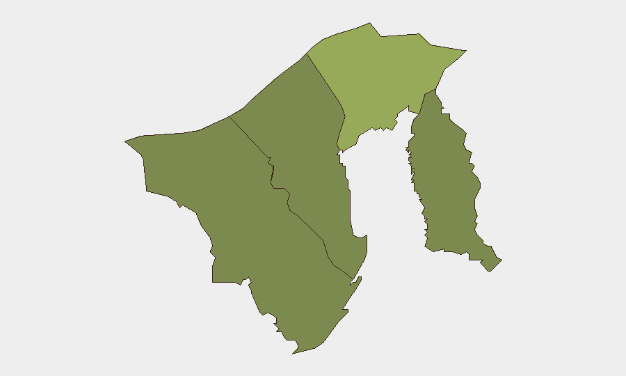
Brunei-Muara District (composite risk score 45) represents the dominant risk concentration, driven primarily by its role as the capital administrative and commercial hub; higher population density, port activity, and critical infrastructure naturally concentrate exposure. Tutong (20), Belait (15), and Temburong (10) present lower but non-zero risk profiles, reflecting smaller populations and more limited asset concentrations. No acute incident clustering has been identified; the risk profile reflects structural factors (population, infrastructure, international activity) rather than imminent threats.
How GeoBit Would Assist
Security teams should deploy persistent AOI (Area-of-Interest) monitoring and early-warning alerting on Bandar Seri Begawan, port facilities, and key cross-border transit zones to detect any shift in activity patterns or emerging incidents before they escalate. OSINT fusion across X/Twitter, regional news feeds, and multi-language search would provide continuous near-real-time coverage of maritime incidents, enforcement actions, and official statements, enabling rapid situational awareness. Environmental & health monitoring capabilities would track heat-stress advisories and air-quality indices, supporting duty-of-care planning for personnel and critical operations.
7-Day Outlook
No deterioration in Brunei's security baseline is anticipated over the next seven days. Regional haze and heat conditions may persist and should be monitored for operational impact, while bilateral Brunei–Malaysia security cooperation is likely to remain routine. Routine maritime enforcement activity and cross-border operations will likely continue; any significant shift would be detectable through standard OSINT and area monitoring.
Highest-Risk Areas — Ranked
| # | State / Region | Risk |
|---|---|---|
| 1 | Brunei-Muara District | 45 |
| 2 | Tutong District | 20 |
| 3 | Belait District | 15 |
| 4 | Temburong District | 10 |
Sources
Previous Daily Briefs
A new Brunei brief is written every day — each with its own risk map and downloadable CSV. Here's the last week; use the calendar to go further back.
- August 24, 2026
- August 22, 2026
- August 20, 2026
- August 18, 2026
- August 16, 2026
- August 14, 2026
- August 12, 2026
📅 Browse every day by calendar →
Highlighted days have a brief. Tap a day for that day's map & analysis, or “csv” for that day's dataset ($5).
Atlas — our AI intelligence desk — emails them this snapshot personally. Nothing else, no list.