Situation Summary
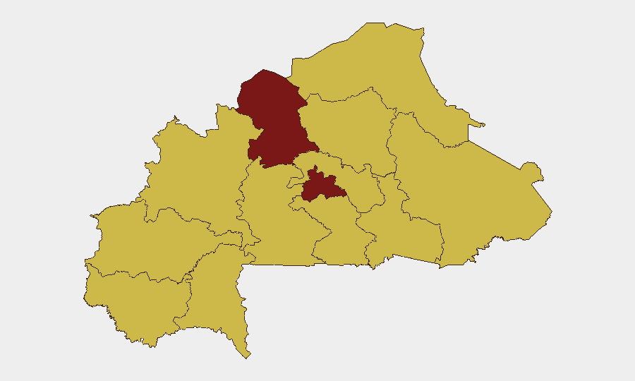
Burkina Faso remains at elevated composite threat level (#14 globally; score 99) with diplomatic friction and border-security tensions accelerating over the past 48 hours. The North region continues to dominate risk metrics (99.5), driven by ongoing armed-group activity; Centre region (82) shows secondary but sustained threat. Recent diplomatic strain with EU and Ghana, coupled with active border hardening and unconfirmed reports of attacks on military positions, point to a deteriorating security environment alongside internal governance friction.
Key Developments
- Ouagadougou, 22 June: Burkina Faso's foreign ministry summoned the EU representative, protesting alleged "false statements" and external interference—signaling fresh diplomatic tension with Western partners at a time of domestic military operations.
- Border sectors (national), 22–23 June: Border surveillance infrastructure expansion and reported deployment of modern surveillance towers indicate active border hardening; simultaneous calls from Côte d'Ivoire for joint patrols suggest regional concern over cross-border security gaps.
- Burkina Faso–Ghana frontier, 22 June: Public statements from both governments reflect renewed bilateral tension affecting border-movement protocols and security coordination; specific incident details remain unconfirmed in independent sources.
- Military installations (location unconfirmed), 22–23 June: Social-media reports describe attacks on Burkina Faso military positions; independent corroboration and precise location data are not yet available and should be treated as preliminary.
- Arrest/detention activity (national), 24 June: Two separate arrest/detention events involving magistrate authority (cases: PROVIDENCE, BAHAMA) suggest ongoing judicial or security operations; operational context and scale remain unclear.
- Company public statement, 24 June: A commercial entity issued a public statement (content and sector unspecified); may reflect corporate risk assessment or operational impact notification.
- Firefighting operations, 23 June (two events): Military-led firefighter mobilization on consecutive dates suggests either natural-disaster response or secondary security/logistics operations; no casualty or scale data confirmed.
Highest-Risk Areas
North and Centre regions drive the national threat profile. The North (99.5) remains the epicenter of armed-group activity, militant recruitment, and inter-factional violence; Centre (82) encompasses the capital and surrounding districts where state authority, governance disputes, and spillover from northern operations converge. The remaining nine regions cluster at 69.5, reflecting widespread diffuse risk rather than isolated hotspots—a pattern consistent with decentralized militant networks and border-adjacent instability. Border zones with Ghana, Mali, and Niger present the highest cross-border threat vectors.
How GeoBit Would Assist
Security teams operating in or monitoring Burkina Faso should prioritize AOI Monitoring & Early Warning on the North region and border sectors to detect militant movement and cross-border incursions in real time. Intel Sweep and multi-language OSINT (including Telegram, X/Twitter, and local radio SIGINT) will track unconfirmed military incidents, arrest activity, and diplomatic signals before mainstream reporting. Network & Actor Analysis and Conflict & Military modules will map armed-group structure and state-force positioning, enabling duty-of-care teams to identify safe-passage windows and avoid high-tempo operational areas. Routing & Network Analysis supports alternative-route planning away from North and border zones.
7-Day Outlook
Diplomatic friction with Western partners and bilateral Ghana tension are likely to sustain over the near term, potentially triggering visa or border-movement restrictions. Military activity in the North and border-hardening operations will remain elevated; unconfirmed reports of attacks may see clarification or escalation. Corporate and expatriate teams should expect continued governance volatility and maintain contingency protocols for restricted movement.
Highest-Risk Areas — Ranked
| # | State / Region | Risk |
|---|---|---|
| 1 | North | 99.5 |
| 2 | Centre | 82 |
| 3 | Upper-Basins | 69.5 |
| 4 | Boucle du Mouhoun | 69.5 |
| 5 | Central-West | 69.5 |
| 6 | Central-South | 69.5 |
| 7 | Central-East | 69.5 |
| 8 | Waterfalls | 69.5 |
| 9 | Southwest | 69.5 |
| 10 | Sahel | 69.5 |
| 11 | Central-North | 69.5 |
| 12 | East | 69.5 |
Sources
Previous Daily Briefs
A new Burkina Faso brief is written every day — each with its own risk map and downloadable CSV. Here's the last week; use the calendar to go further back.
📅 Browse every day by calendar →
Highlighted days have a brief. Tap a day for that day's map & analysis, or “csv” for that day's dataset ($5).