Situation Summary
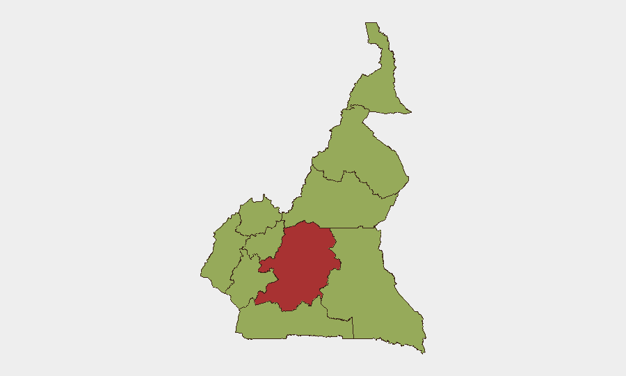
Cameroon remains at composite threat level 70 (rank #26 globally), driven primarily by active insurgency in the Far North and ongoing Anglophone-linked violence in the Northwest and Southwest. The past 48 hours have seen scattered but significant incidents—weapons trafficking, Boko Haram killings, and inter-community clashes—alongside mounting political-economic pressure signaled by parliament. The Centre region (Yaoundé corridor) carries the highest sub-national risk score (78.7), reflecting both capital-area governance tensions and proximity to conflict zones.
Key Developments
- Touboro, North Region (11 June) – Customs and security forces seized approximately 2,000 bladed weapons near Bogdibo, Touboro, in a major anti-trafficking operation; seizure reflects ongoing weapons-circulation risks in the northern corridor.
- Mayo-Sava Division, Far North (9–11 June) – Three civilians killed by Boko Haram insurgents over a two-day period; consistent with ongoing Lake Chad basin violence targeting non-combatants.
- Nkor, Noni Sub-Division, Northwest Region (recent days, reported 11 June) – Four fatalities (two soldiers, two women) in clash linked to Anglophone crisis; incident reflects persistent Northwest volatility despite no recent major escalation announcements.
- Mayo-Tsanaga Division, Far North (reported 11 June) – Chieftaincy leadership dispute in Mayo-Tchoukouri noted as serious internal conflict with potential implications for local stability; no physical violence reported to date but flagged as active political-traditional tension.
- Northern Power Grid (10–11 June) – Newly inaugurated cement plant forced into shutdown due to deepening power crisis in North Region; underscores infrastructure reliability and logistics disruption risk for industrial operations.
- National Assembly, Yaoundé (11 June) – Parliamentary leadership called on executive to urgently address rising cost of living, land reform, and mining transparency; signals mounting socio-economic strain and governance deficit concerns within political establishment.
Highest-Risk Areas
The Centre region (score 78.7) stands apart, driven by Yaoundé's role as the capital and administrative hub—where political-economic pressures are most visible and where decisions cascading to other regions originate. The Far North (score 48.7) faces sustained Boko Haram and Lake Chad basin insurgency, with civilian targeting and periodic mass casualty events. The Northwest and Southwest (both 48.7) remain destabilized by the Anglophone crisis, characterized by armed separatist activity, community clashes, and civilian displacement. All other regions score uniformly at 48.7, reflecting Cameroon's geographically distributed but lower-intensity baseline risks (petty crime, banditry, inter-communal disputes).
How GeoBit Would Assist
Security teams should employ Intel Sweep and multi-language OSINT fusion to track fragmented local reporting from outlets such as L'Oeil du Sahel and Mimi Mefo Info—currently the most reliable near-real-time signals for Far North and Northern region incidents. AOI Monitoring & Early Warning on the Centre region (Yaoundé) and key corridors (Yaoundé–Ngaoundéré, Douala–Bafoussam) would provide persistent alerting on political, economic, and security friction before escalation. GIS & Spatial Analysis combined with Routing & Network Analysis can assist duty-of-care teams in assessing alternative corridors and identifying safe transit windows for personnel and assets in high-risk sub-national zones.
7-Day Outlook
Near-term volatility remains likely, particularly in Far North (continued Boko Haram activity) and Northwest (simmering Anglophone tensions). Parliamentary pressure on socio-economic governance suggests potential for increased street-level protest or civil unrest in Yaoundé and other urban centers if cost-of-living grievances are not addressed. No imminent large-scale military escalation is signaled, but persistent low-intensity insurgency, weapons trafficking, and communal conflict will continue to elevate risk in the sub-national zones already flagged.
Highest-Risk Areas — Ranked
| # | State / Region | Risk |
|---|---|---|
| 1 | Centre | 78.7 |
| 2 | Northwest | 48.7 |
| 3 | Southwest | 48.7 |
| 4 | West | 48.7 |
| 5 | Littoral | 48.7 |
| 6 | Adamawa | 48.7 |
| 7 | South | 48.7 |
| 8 | Far-North | 48.7 |
| 9 | North | 48.7 |
| 10 | East | 48.7 |
Previous Daily Briefs
A new Cameroon brief is written every day — each with its own risk map and downloadable CSV. Here's the last week; use the calendar to go further back.
📅 Browse every day by calendar →
Highlighted days have a brief. Tap a day for that day's map & analysis, or “csv” for that day's dataset ($5).