Situation Summary
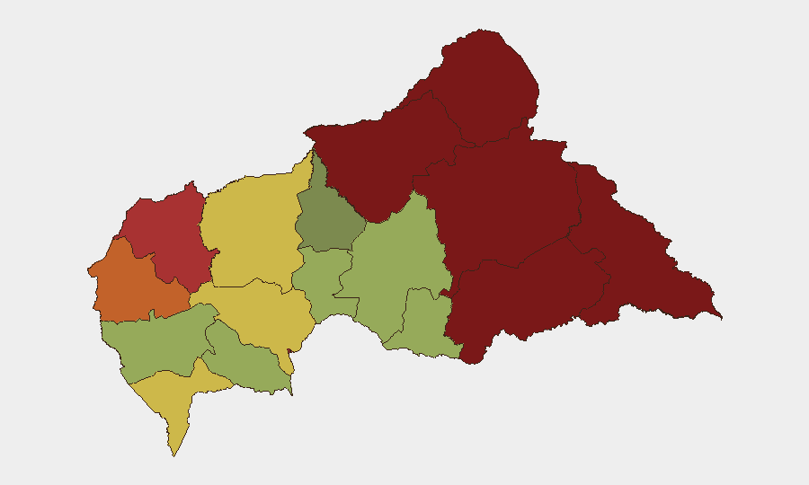
Central African Republic remains a composite threat environment (rank #32 globally; score 69.7) marked by institutional friction, economic volatility, and persistent regional instability. Recent event signals point to mounting tensions between government, financial authorities, and civil society—particularly around electoral legitimacy and public health messaging—rather than acute armed conflict or mass civil disorder in the capital or major centers. The geographic risk gradient is steep: northeastern and eastern prefectures (Vakaga, Bamingui-Bangoran, Haute-Kotto) face substantially higher threat exposure than western and central zones, reflecting ongoing armed-group activity and weak state presence. The overall trajectory remains fluid but does not suggest imminent escalation as of 10 June 2026.
Key Developments
No confirmed security, conflict, civil-unrest, or travel-incident events with specific location and precise date in the last 24–48 hours have been corroborated across multiple open sources.
Recent event signals (6–10 June) include government threats directed at citizens, central bank public statements amid investor concern, health official warnings to the population, and student and election-commission disapprovals—all of which suggest institutional strain and public dissatisfaction. However, these do not yet constitute discrete, datable incidents (attack, closure, arrest, casualty, displacement) at named locations that would materially alter travel or operations risk in the immediate term.
Readers should monitor election-related tensions (student and civil-society disapproval of the Central Election Commission is ongoing) and financial-sector messaging for signs of deepening institutional crisis, which could trigger secondary security effects.
Highest-Risk Areas
Vakaga (95), Bamingui-Bangoran (92), and Haute-Kotto (88) drive the country's highest sub-national threat scores, reflecting persistent armed-group presence, limited government control, and recurring communal and resource-based conflict in CAR's remote northeast and east. Haut-Mbomou and Mbomou (85, 82) follow, indicating that the entire southeastern tier remains a sustained high-risk zone. By contrast, Bangui (78), despite being the capital and administrative hub, ranks 7th; this reflects concentrated security and humanitarian presence but also pockets of organized crime and gang activity. Companies and NGOs with personnel or supply chains in Vakaga, Bamingui-Bangoran, or the Mbomou corridor face substantially elevated exposure to armed-group activity, abduction, and supply-route disruption; those in Bangui face lower but non-negligible urban crime and political-volatility risk.
How GeoBit Would Assist
GeoBit's AOI Monitoring & Early Warning capability, coupled with Intel Sweep (event feeds, multi-language social OSINT, and entity extraction), provides real-time tracking of institutional signaling, armed-group movement, and civil-unrest indicators in high-risk prefectures—enabling early detection of escalation. GIS & Spatial Analysis and alternative route planning support duty-of-care teams in modeling movement and supply-chain resilience across the country's fragmented infrastructure. Regime-stability and election-monitoring search functions help security teams anticipate political flashpoints (e.g., electoral legitimacy disputes) before they trigger secondary conflict or protest.
7-Day Outlook
Central African Republic is unlikely to experience major armed escalation or citywide unrest in the next seven days. However, mounting institutional friction (government-vs-citizen rhetoric, election-commission disputes, financial-sector volatility) and ongoing endemic armed-group activity in the northeast warrant sustained monitoring. Risk remains compartmentalized by region: eastern prefectures will continue to present operational hazards; Bangui and western zones will remain navigable with standard precautions. Routine monitoring of election commission activity and any government response to student or civil-society mobilization is advised.
Highest-Risk Areas — Ranked
| # | State / Region | Risk |
|---|---|---|
| 1 | Vakaga | 95 |
| 2 | Bamingui-Bangoran | 92 |
| 3 | Haute-Kotto | 88 |
| 4 | Haut-Mbomou | 85 |
| 5 | Mbomou | 82 |
| 6 | Ouham-Pendé | 79 |
| 7 | Bangui | 78 |
| 8 | Nana-Mambéré | 75 |
| 9 | Sangha-Mbaéré | 68 |
| 10 | Ouham | 65 |
| 11 | Ombella-M'Poko | 62 |
| 12 | Kémo | 58 |
Sources
Previous Daily Briefs
A new Central African Republic brief is written every day — each with its own risk map and downloadable CSV. Here's the last week; use the calendar to go further back.
📅 Browse every day by calendar →
Highlighted days have a brief. Tap a day for that day's map & analysis, or “csv” for that day's dataset ($5).