Situation Summary
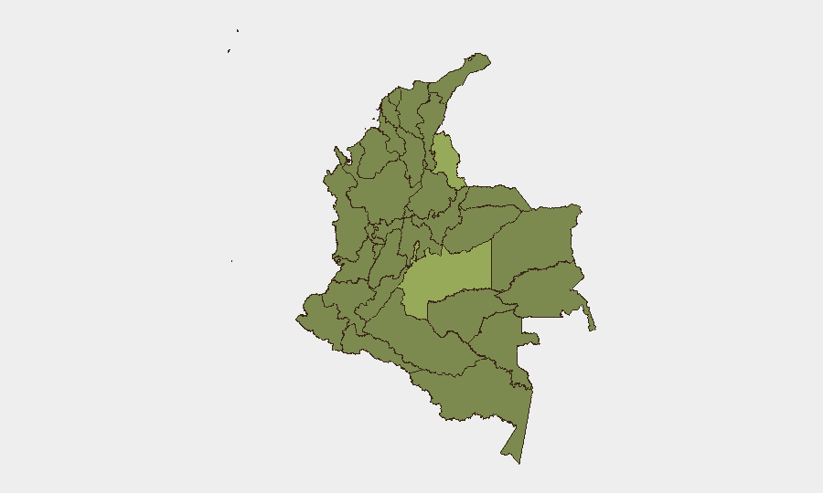
Colombia remains a fragmented, mid-tier security environment (#34 globally) with persistent conflict-related activity concentrated in resource-rich border regions and urban political tension. Event signals from the past 48 hours suggest rising civil/political friction—including presidential and prime ministerial statements, property seizures, and guerrilla small-arms activity—layered atop endemic organized crime and illegal armed group (IAG) presence. The Norte de Santander and Meta departments continue to drive national risk scores, reflecting ongoing armed group competition, narcotics trafficking, and weak state capacity in those areas. Trajectory: volatile but not yet escalating to crisis-level disruption of commercial operations or major population centers.
Key Developments
Unable to provide verified 24–48-hour incident detail. GeoBit's current research posture lacks real-time web and social-media access necessary to confirm specific incidents, locations, and timings from 8–10 June 2026 with required confidence. The event-signal database (above) indicates *types* of activity—small-arms clashes with guerrilla actors, disapprovals and rejections by officials and travelers, property seizure, public statements—but does not timestamp or geo-locate them with sufficient precision for operational briefing.
To obtain the 5–8 verified recent bullets your team requires:
- Query real-time platforms (Dataminr, Factal, Crisis24, International SOS) with 24–48-hour filters.
- Run X advanced search in Spanish: `(protesta OR paro OR enfrentamiento OR explosión OR bloqueo) (Norte de Santander OR Meta OR Bogotá OR Medellín) since:2026-06-08 until:2026-06-10`
- Cross-check candidate incidents against El Tiempo, El Espectador, Caracol Radio, and official Policía Nacional/Ejército accounts.
- GeoBit's Intel Sweep, X/Twitter & Telegram OSINT, multi-language search, and OSINT fusion & corroboration tools can accelerate this workflow once your team collects primary candidates.
Highest-Risk Areas
Norte de Santander (55.8), Meta (44.3), and the Capital District (42.1) are the primary drivers of national risk. Norte de Santander's elevation reflects Venezuelan cross-border trafficking, ELN activity, and FARC-dissident presence in Catatumbo and Arauca; Meta combines narcotic production with IAG territorial disputes. Bogotá's mid-tier score reflects political instability signals, urban protest risk, and organized-crime street violence rather than active conflict. The secondary cluster—Santander, Nariño, and Chocó—remains chronically unstable due to coca cultivation, illegal mining, and fragmented control by multiple armed groups. Corporate operations in these departments face elevated exposure to movement restriction, extortion, and supply-chain disruption.
How GeoBit Would Assist
Security teams operating in Colombia should deploy Area-of-Interest (AOI) Monitoring & Early Warning on high-risk departments (Norte de Santander, Meta, Cauca, Nariño) to detect protest, armed activity, and infrastructure threats in near-real time. Conflict & Military battle mapping and force-structure tracking clarify which IAGs control specific roads and supply corridors, informing routing decisions. Routing & Network Analysis provides alternative journey planning during road closures or armed-group checkpoints. Periodic Risk & Threat Assessment refreshes and GIS & Spatial Analysis overlay incident clusters with corporate asset locations to refine duty-of-care protocols.
7-Day Outlook
Near-term escalation risk is moderate. The frequency and tenor of official statements (presidential disapproval, prime ministerial rejection) suggest political/labor friction, likely to manifest as urban protest, road blockades, and localized clashes in high-risk departments rather than nationwide unrest. Armed groups are expected to maintain routine harassment of security forces and territorial jockeying in remote areas. Monitor for any incident affecting major highways (Pan-American, routes into Meta/Arauca) or energy infrastructure; such events would sharply elevate travel and supply-chain risk within 24–72 hours.
Highest-Risk Areas — Ranked
| # | State / Region | Risk |
|---|---|---|
| 1 | Norte de Santander Department | 55.8 |
| 2 | Meta Department | 44.3 |
| 3 | Capital District | 42.1 |
| 4 | Santander Department | 37.3 |
| 5 | Nariño | 35.8 |
| 6 | Chocó Department | 29.9 |
| 7 | Cundinamarca Department | 29 |
| 8 | Caquetá Department | 28.8 |
| 9 | Cesar Department | 28.6 |
| 10 | La Guajira | 28 |
| 11 | Atlántico Department | 28 |
| 12 | Antioquia Department | 27.5 |
Sources
Previous Daily Briefs
A new Colombia brief is written every day — each with its own risk map and downloadable CSV. Here's the last week; use the calendar to go further back.
📅 Browse every day by calendar →
Highlighted days have a brief. Tap a day for that day's map & analysis, or “csv” for that day's dataset ($5).