Situation Summary
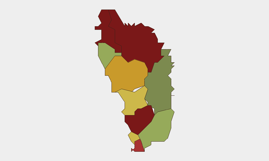
Dominica's overall security environment remains stable, with a composite threat score of 50 and no confirmed security incidents, civil unrest, or travel disruptions reported in the last 24–48 hours. Web and open-source monitoring found no credible, time-stamped incidents affecting national security, critical infrastructure, or personnel safety. However, sub-national risk concentration in the northern parishes—particularly Saint Andrew, Saint John, and Saint George—warrants ongoing monitoring despite the current absence of acute event-level activity.
Key Developments
- No confirmed security incidents, 30–31 July 2026 (nationwide). Aggregated intelligence feeds, news monitoring, and social-media analysis confirm absence of discrete incidents affecting Dominica proper in the current 24–48h window.
- Unverified social-media claim regarding curfew/State of Emergency (timeline unclear, unconfirmed). A circulating post references emergency declarations; however, this claim is not corroborated by official Dominican government statements, reputable news outlets, or reliable timestamp data, and is not treated as actionable.
- Routine political activity in Roseau (30–31 July 2026). Capital-level governance messaging and political communications assessed as normal; no associated protests, unrest, or security incidents detected.
- Saint Andrew, Saint John, Saint George parishes flagged for structural risk (ongoing). These northern parishes maintain elevated composite risk scores (92, 88, and 81 respectively) and remain under monitoring; however, no new discrete incidents (crime spikes, infrastructure failure, civil unrest) have been logged in the last 24–48 hours.
- Regional confusion with Dominican Republic (30–31 July 2026). Social-media signals referencing Caribbean unrest predominantly concern the Dominican Republic; mis-attribution to Dominica has been identified and discounted.
- No aviation, port, or transportation disruptions (30–31 July 2026). Critical logistics infrastructure and travel corridors operational; no alerts issued.
Highest-Risk Areas
Saint Andrew Parish (risk 92) and Saint John Parish (risk 88) dominate the sub-national risk profile, followed by Saint George Parish (81). These northern parishes account for structural vulnerability across crime, governance, and service-delivery metrics. The southern parishes—Saint David (35) and Saint Patrick (48)—present substantially lower risk. This concentration suggests that any future incident-level activity is most probable in the northern tier; personnel, operations, and asset concentrations in Saint Andrew and Saint John parishes warrant priority in contingency planning, even given current stability.
How GeoBit Would Assist
Teams managing personnel or assets in Dominica should use AOI Monitoring & Early Warning to establish persistent watch on Saint Andrew and Saint John parishes with automated alerting on crime, civil unrest, or infrastructure disruption. Intel Sweep and multi-language OSINT fusion across news, social media, and government sources will disambiguate local incidents from regional events and validate or refute claims such as the unconfirmed curfew report. Network & Actor Analysis and Conflict & Military capabilities can track any escalation involving state or non-state actors, while Routing & Network Analysis supports contingency planning for personnel evacuation or supply-chain continuity if conditions shift.
7-Day Outlook
No acute deterioration is forecast over the next 7 days based on current open-source signals and structural risk data. However, the elevated baseline risk in northern parishes and the circulation of unverified emergency claims warrant continued daily monitoring to detect any shift from routine activity to incident-level events. Duty-of-care teams should maintain readiness to escalate if credible, time-stamped reporting emerges from official channels or corroborated open sources.
Highest-Risk Areas — Ranked
| # | State / Region | Risk |
|---|---|---|
| 1 | Saint Andrew Parish | 92 |
| 2 | Saint John Parish | 88 |
| 3 | Saint George Parish | 81 |
| 4 | Saint Mark Parish | 78 |
| 5 | Saint Joseph Parish | 72 |
| 6 | Saint Paul Parish | 68 |
| 7 | Saint Luke Parish | 62 |
| 8 | Saint Peter Parish | 55 |
| 9 | Saint Patrick Parish | 48 |
| 10 | Saint David Parish | 35 |
Sources
Previous Daily Briefs
A new Dominica brief is written every day — each with its own risk map and downloadable CSV. Here's the last week; use the calendar to go further back.
📅 Browse every day by calendar →
Highlighted days have a brief. Tap a day for that day's map & analysis, or “csv” for that day's dataset ($5).
Atlas — our AI intelligence desk — emails them this snapshot personally. Nothing else, no list.