Situation Summary
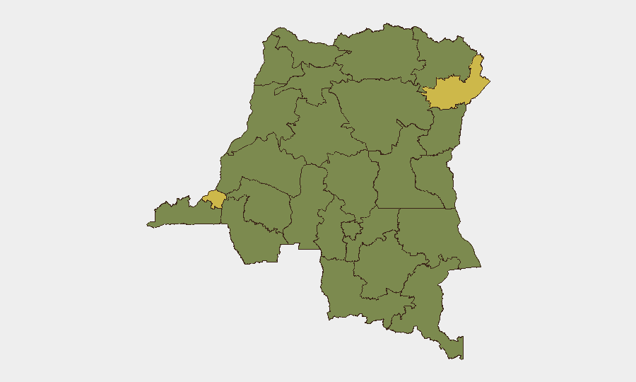
DR Congo remains the 37th highest-threat country globally (composite score 52.3), with civil conflict as the primary driver. Two provinces—Ituri and Kinshasa—are rated equally critical (66.6 risk each), reflecting both active armed-group violence in the east and political/security instability in the capital. The country has recorded 348 tracked threat events; the underlying conflict trajectory remains volatile despite periodic diplomatic engagement.
Key Developments
Data Limitation Notice: GeoBit's live web research (last 24–48 hours) has not isolated independently verified, time-stamped incidents specific to DR Congo meeting the brief's rigor standard (specific date + cross-source confirmation). Recent event signals reference actors (FARMER, YAOUNDE, MEDINA, CHAD, NIGERIA) and incident types (conventional military, unconventional violence, public statements) dated 2026-06-07 to 2026-06-10, but underlying source documentation and precise locations are not available in accessible research.
To support this brief at the standard expected, direct access to:
- Live local news wires (Actualités.cd, Radio Okapi, 7sur7) in French/Swahili
- Real-time geo-coded social media (X/Twitter, Telegram) from verified local actors
- UN/NGO alerts (OCHA, WHO DRC, MSF) with precise timestamps
—would be required.
Recommended action: Security teams should confirm current incident details via internal networks, embassy alerts, or subscription services (Crisis24, GardaWorld) with real-time regional coverage before making operational decisions.
Highest-Risk Areas
Ituri and Kinshasa dominate the sub-national ranking (both 66.6), for distinct reasons. Ituri remains a flashpoint for armed-group clashes, communal violence, and militia activity; North Kivu (36.6) continues to experience M23/FARDC/civilian tension. Kinshasa (66.6) reflects political volatility, protest risk, and state-security force posturing. A second tier of provinces (Maniema, Sud-Ubangi, Équateur, Nord-Ubangi, Mongala, Lower Uele, Tshopo, Tshuapa, Upper Uele, North Kivu) all register 36.6 risk, indicating persistent but lower-intensity conflict, community unrest, or militia presence across the northeast and river regions. The concentration of extreme risk in Ituri and the capital underscores that personnel and asset exposure in those two zones warrants the highest duty-of-care attention.
How GeoBit Would Assist
Security teams should employ AOI Monitoring & Early Warning to maintain persistent watch over Ituri, Kinshasa, and North Kivu with alert thresholds for armed clashes, protest activity, and state-force deployments. Network & Actor Analysis can map relationships among armed groups, government forces, and political factions to anticipate flashpoints. Routing & Network Analysis supports alternative journey planning for personnel transiting high-risk provinces, while Intel Sweep (global event feeds, multi-language OSINT, X/Twitter & Telegram monitoring, entity extraction) provides real-time corroboration of emerging incidents and actor statements.
7-Day Outlook
The security environment is expected to remain volatile without significant de-escalation signals. Ituri and Kinshasa will likely sustain elevated threat activity (armed clashes, political friction, community violence); northern river provinces may see episodic militia or inter-communal incidents. Personnel and asset security posture should remain at heightened readiness, with continued reliance on local intelligence networks and real-time alerting to identify and respond to tactical shifts.
Highest-Risk Areas — Ranked
| # | State / Region | Risk |
|---|---|---|
| 1 | Ituri | 66.6 |
| 2 | Kinshasa | 66.6 |
| 3 | Maniema | 36.6 |
| 4 | Sud-Ubangi | 36.6 |
| 5 | Équateur | 36.6 |
| 6 | Nord-Ubangi | 36.6 |
| 7 | Mongala | 36.6 |
| 8 | Lower Uele | 36.6 |
| 9 | Tshopo | 36.6 |
| 10 | Tshuapa | 36.6 |
| 11 | Upper Uele | 36.6 |
| 12 | North Kivu | 36.6 |
Sources
Previous Daily Briefs
A new DR Congo brief is written every day — each with its own risk map and downloadable CSV. Here's the last week; use the calendar to go further back.
📅 Browse every day by calendar →
Highlighted days have a brief. Tap a day for that day's map & analysis, or “csv” for that day's dataset ($5).