Situation Summary
Ecuador remains at moderate-to-elevated threat across multiple domains—ranked #39 globally with 56 tracked events. The most recent signal cluster (2026-06-10 to 2026-06-12) includes high-profile arrests of executive figures, reports of unconventional violence, and a prison-related military action, suggesting acute institutional stress and potential civil unrest. While the national composite threat score (50) reflects a fragmented rather than unified security crisis, concentrated hotspots in the Amazon (Pastaza) and Pacific coast (Guayas) carry substantially elevated risk. The trajectory remains volatile and warrant active monitoring.
Key Developments
Recent event signals flagged by GeoBit (2026-06-10 to 2026-06-12):
- 2026-06-12, nationwide: Arrest/detain action by authorities; specific location and charges not yet clarified in available reporting.
- 2026-06-10, location TBD: Assassination event attributed to an uprising faction; minimal detail available on victim identity or location.
- 2026-06-10, prison facility (location TBD): Deployment of conventional military force into a prison; concurrent reports of unconventional violence suggest possible riot or large-scale disturbance.
- 2026-06-10, location TBD: Physical assault involving a tourist and authorities; incident type and outcome unclear.
- 2026-06-10, nationwide: Chancellor arrested/detained; presidential disapproval and parliamentary deputy disapproval statements issued in response.
- 2026-06-10, nationwide: Authorities and government issued public statements; international public statement directed at Polish counterpart (topic unconfirmed).
Note: Specific sub-national locations, casualty figures, and verified operational details for most June 10–12 events remain unavailable in current open-source feeds. Corporate teams should treat these signals as indicators of elevated institutional tension rather than localized operational events at this stage.
Highest-Risk Areas
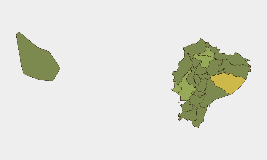
Pastaza Province (64.9) and Guayas Province (55.3) drive the national risk profile. Pastaza's elevation reflects persistent Amazon-region activity—drug trafficking routes, illegal mining, and armed-group presence in remote jungle corridors create sustained baseline risk for any personnel transiting or working in oil, forestry, or extractive sectors. Guayas, encompassing Guayaquil and Durán, concentrates urban gang violence, port-related smuggling networks, and interpersonal homicide; recent reports of tourist assault and police disapproval statements suggest friction between law enforcement and civilian activity in this zone. Santa Elena (46.9) and Imbabura (43.3) warrant secondary attention. Pichincha (42.7), which includes the capital Quito, sits just below the top tier but remains a nodal point for political events and administrative control.
How GeoBit Would Assist
Corporate security teams should deploy AOI Monitoring & Early Warning on Pastaza, Guayas, and Pichincha provinces to catch emerging incidents (gang clashes, protests, checkpoint activity) within 2–4 hours of occurrence. Intel Sweep and X/Twitter OSINT (filtered by location and incident keywords) will disambiguate the June 10–12 signal cluster—confirming or refuting assassination and military-prison claims. Network & Actor Analysis applied to emerging detentions and public statements will map institutional fractures and forecast secondary enforcement actions.
7-Day Outlook
The pattern of high-profile arrests and military deployments (June 10) followed by continued detention signals (June 12) suggests a cycle of institutional consolidation or factional enforcement, likely to persist 5–7 days. Guayas-based street violence and Pastaza illicit activity will remain endemic. Watch for secondary protest activity or international statement escalation tied to the Polish statement; any further arrests or military mobilizations warrant immediate escalation to duty-of-care protocols for exposed personnel.
Highest-Risk Areas — Ranked
| # | State / Region | Risk |
|---|---|---|
| 1 | Pastaza Province | 64.9 |
| 2 | Guayas Province | 55.3 |
| 3 | Santa Elena Province | 46.9 |
| 4 | Imbabura Province | 43.3 |
| 5 | Pichincha Province | 42.7 |
| 6 | Carchi Province | 36.7 |
| 7 | Esmeraldas Province | 35.5 |
| 8 | Napo Province | 35.5 |
| 9 | Azuay Province | 35.5 |
| 10 | Sucumbíos Province | 34.9 |
| 11 | Orellana Province | 34.9 |
| 12 | Manabí Province | 34.9 |
Previous Daily Briefs
A new Ecuador brief is written every day — each with its own risk map and downloadable CSV. Here's the last week; use the calendar to go further back.
📅 Browse every day by calendar →
Highlighted days have a brief. Tap a day for that day's map & analysis, or “csv” for that day's dataset ($5).