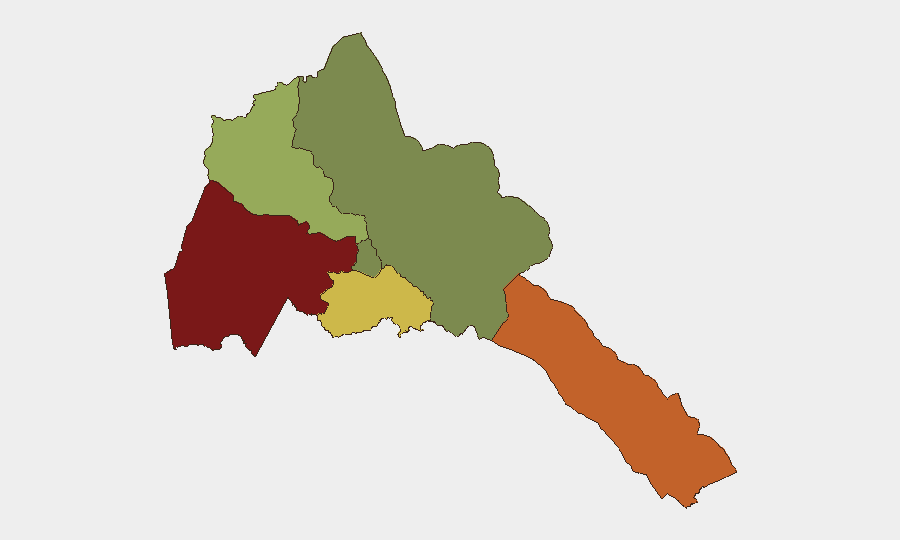
Situation Summary
Eritrea remains a low-frequency acute-threat environment with no documented security incidents, infrastructure disruptions, or civil unrest in the last 24–48 hours. The country's composite threat ranking (6/100 globally, #148) reflects chronic state-level human-rights and governance concerns rather than active conflict or crime waves. Near-term on-the-ground security for personnel and assets is stable, though underlying political repression and regional strategic sensitivities persist.
Key Developments
- Geneva, Switzerland (UN Human Rights Council) – 8 July 2026: The UN Human Rights Council renewed the mandate of the Special Rapporteur on Eritrea's human-rights situation despite an intensive lobbying campaign by Eritrea's UN ambassador to terminate it. The renewal signals sustained international pressure on Asmara over documented arbitrary detention, torture, and enforced disappearances.
- New York, USA (UN Headquarters) – June–early July 2026: Eritrea's diplomatic mission conducted a high-profile campaign to end external UN human-rights scrutiny, ultimately unsuccessful. The rebuff underscores Eritrea's defiant posture toward accountability mechanisms and reinforces international concern about systemic abuses.
- International human-rights networks – early July 2026: Christian Solidarity Worldwide and allied advocacy groups publicly welcomed the UNHRC mandate renewal, emphasizing ongoing documentation of severe violations and calling for sustained pressure on Asmara's governance practices.
- Red Sea region / strategic commentary – 7 July 2026: Regional security analysts referenced Eritrea's port infrastructure in broader Horn of Africa logistics and security doctrine discussions; no new incident or infrastructure disruption was reported, but the commentary underscores persistent international attention to Eritrean coastal chokepoints.
- No acute on-the-ground incidents reported – last 48 hours: Open-source monitoring, X/Twitter OSINT, and international news feeds confirm no credible reports of protests, armed clashes, terrorism, crime spikes, or infrastructure failures within Eritrea in the immediate reporting window.
Highest-Risk Areas
Gash-Barka (risk 92) and the Southern Red Sea Region (risk 75) drive GeoBit's sub-national rankings, likely reflecting border permeability, smuggling networks, and proximity to conflict zones in Sudan and the Tigray region. Debub Region (risk 68) carries elevated concern, possibly linked to historical armed-group presence and cross-border activity. By contrast, Maekel Region (Asmara and central highlands, risk 18) and the Northern Red Sea Region (risk 0) present minimal tracked risk, consistent with tighter state control and limited civil unrest. Personnel concentrated in or transiting through the western and southern periphery face heightened exposure to smuggling, trafficking, and residual militant activity; core urban areas remain low-incident zones.
How GeoBit Would Assist
Security teams should deploy AOI Monitoring & Early Warning on Gash-Barka and Southern Red Sea Region to detect cross-border movement, trafficking, or militant activity before it escalates. Intel Sweep and multi-language OSINT (X/Twitter, local media, humanitarian networks) would provide continuous low-cost coverage of political repression signals, detention campaigns, or refugee flows that could trigger regional instability. Routing & Network Analysis would support safe travel planning for personnel transiting western border zones and identify alternative corridors if cross-border activity intensifies.
7-Day Outlook
No imminent acute security deterioration is forecast. Diplomatic pressure on Eritrea's human-rights record will persist at the UN, but this is unlikely to trigger immediate on-the-ground unrest or policy changes. Border zones merit continued passive monitoring for trafficking and cross-border militia activity; core urban areas should remain stable. Personnel and asset posture requires no immediate adjustment, though teams in the west and south should maintain heightened situational awareness.
Highest-Risk Areas — Ranked
| # | State / Region | Risk |
|---|---|---|
| 1 | Gash-Barka | 92 |
| 2 | Southern Red Sea Region | 75 |
| 3 | Debub Region | 68 |
| 4 | Anseba | 55 |
| 5 | Maekel Region | 18 |
| 6 | Northen Red Sea Region | 0 |
Sources
Previous Daily Briefs
A new Eritrea brief is written every day — each with its own risk map and downloadable CSV. Here's the last week; use the calendar to go further back.
📅 Browse every day by calendar →
Highlighted days have a brief. Tap a day for that day's map & analysis, or “csv” for that day's dataset ($5).
Atlas — our AI intelligence desk — emails them this snapshot personally. Nothing else, no list.