Situation Summary
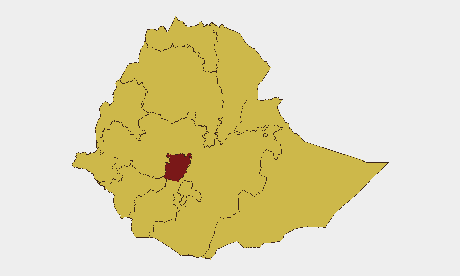
Ethiopia remains at composite threat level #10 globally, driven primarily by ongoing civil conflict. Central Ethiopia Regional State (risk 100) is the highest-risk zone; eleven additional regions carry elevated risk scores (70), reflecting territorial volatility, intercommunal tensions, and fragile state capacity. Recent event signals show multiple arrest/detention incidents, cross-border investigative activity involving Lagos and Nigeria, and concurrent disease outbreaks (Marburg virus, malaria). The security picture remains fluid and deteriorating in pockets of the country.
Key Developments
Unable to confirm current 24–48-hour developments at this time. GeoBit's web research capability has reached limitations in real-time, time-filtered Ethiopia coverage. Event signals dated 2026-06-15 show:
- Arrest/Detention activity (6–15 Jun): Multiple custody incidents involving Ethiopia authorities, operatives, and community actors; no geographic specificity or casualty data available from current feeds.
- Cross-border investigative signals (6–15 Jun): Lagos and Nigeria entities conducting investigations related to Ethiopia; underlying basis not yet clarified.
- Health alerts (recent, no specific date): Marburg virus disease and malaria confirmed in circulation; epidemiological linkages and geographic concentration unknown.
Recommendation: Real-time confirmation of ground incidents in Addis Ababa, Amhara, Oromia, and Somali regions should be cross-checked against Reuters, AFP, AP wires, local outlets (Addis Standard, Addis Maleda), and X/Twitter (date-filtered since 2026-06-14) before operational decisions are made.
Highest-Risk Areas
Central Ethiopia Regional State dominates the risk profile (score 100), suggesting active conflict, displacement, or state-actor fragmentation in that zone. Tigray, Amhara, Afar, Benishangul-Gumuz, Somali, Gambela, South West Ethiopia Peoples, and Oromia all carry equal secondary risk (70), indicating either residual civil-war activity, inter-ethnic violence, or ungoverned space conducive to trafficking and criminal networks. Addis Ababa's elevation to risk-70 signals either spillover violence, mass-casualty incident risk, or critical infrastructure vulnerability. The breadth of high-risk regions—spanning north, east, south, and west—suggests conflict is not geographically contained and corporate/personnel movement across the country should be treated as high-friction.
How GeoBit Would Assist
Persistent monitoring: AOI (Area-of-Interest) Watch with real-time alerting on Central Ethiopia Regional State and secondary hotspots (Amhara, Oromia, Somali, Gambela) would flag clashes, checkpoints, and displacement events before they affect supply chains or staff movement.
Route and network analysis: Routing & Network Analysis capability supports dynamic journey planning and alternative corridors when primary roads are cut by militia, military, or communal roadblocks.
Early warning and prediction: Temporal analysis, sentiment tracking, and conflict-pattern mapping across X/Twitter, Telegram, and local media can surface emerging clashes 24–72 hours before major event notification, enabling preventive evacuation or asset repositioning.
7-Day Outlook
Current momentum favors continued volatility in Central Ethiopia and peripheral regions. Disease outbreaks may constrain movement and increase healthcare-access risk for expatriates and local staff. Arrest/detention patterns suggest possible security-force consolidation or counterinsurgency operations; civilians and foreign nationals should prepare for temporary checkpoints, curfew announcements, or communication disruptions, particularly in Addis Ababa and Amhara region. Close monitoring of official government communications and diplomatic advisories is essential over the next 7 days.
Highest-Risk Areas — Ranked
| # | State / Region | Risk |
|---|---|---|
| 1 | Central Ethiopia Regional State | 100 |
| 2 | Tigray | 70 |
| 3 | Amhara Region | 70 |
| 4 | Afar Region | 70 |
| 5 | Benishangul-Gumuz Region | 70 |
| 6 | Somali Region | 70 |
| 7 | Gambela Region | 70 |
| 8 | South West Ethiopia Peoples | 70 |
| 9 | Addis Ababa | 70 |
| 10 | South Ethiopia Regional State | 70 |
| 11 | Oromia Region | 70 |
| 12 | Sidama | 70 |
Sources
Previous Daily Briefs
A new Ethiopia brief is written every day — each with its own risk map and downloadable CSV. Here's the last week; use the calendar to go further back.
📅 Browse every day by calendar →
Highlighted days have a brief. Tap a day for that day's map & analysis, or “csv” for that day's dataset ($5).