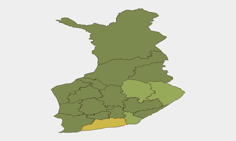
Situation Summary
Finland remains a low-threat environment globally (rank #162, composite score 7) with no tracked discrete security events this week. However, the past seven days have revealed a pattern of border-management challenges, irregular migration attempts, and ongoing infrastructure-security concerns tied to Russian activity and hybrid threats. The country's strategic position as NATO's longest land frontier with Russia, combined with persistent drone incursions and undersea infrastructure vulnerabilities, sustains elevated operational vigilance despite the absence of major incidents.
Key Developments
- Joensuu border area (North Karelia), 11 Sep 2026: Finnish Border Guard detained a person who illegally crossed the land border from Russia and requested asylum; preliminary investigation into border violation opened and Russian authorities contacted.
- Port of Helsinki, 11 Sep 2026: Border officials discovered six foreign nationals (five Eritrean, one Moroccan) hidden in a vehicle arriving from Tallinn; the vehicle driver remanded on suspicion of arranging illegal entry.
- National investigation concluded, 9 Sep 2026: The National Bureau of Investigation and Border Guard concluded criminal investigations into four Ukrainian military drones with explosives that entered Finnish airspace in spring 2026; prosecutor declined to pursue criminal liability but classified entries as unlawful territorial violations.
- Eastern Finland land border, 9 Sep 2026: Authorities reported completion of a 200 km security fence along the Russian border, framed as strengthening NATO's eastern perimeter against hybrid attacks and irregular migration.
- Helsinki medical facility, 10 Sep 2026: Helsinki Police conducted a search at a private plastic surgery clinic on Aleksanterinkatu following a patient death; clinic suspended operations due to safety concerns.
- Helsinki maritime area, 9 Sep 2026 (announced; exercises begin 15 Sep): Authorities announced start of Marsec EU26 "Livex 2" maritime security exercises involving Helsinki Police, Border Guard coast guard districts, air patrol, and military units, focused on maritime security and emergency response.
- Pori (Southwest Finland), 10 Sep 2026: Police now suspect driving while intoxicated in a previously fatal pedestrian crash based on blood tests; investigating as aggravated causing of death and aggravated endangerment of road safety.
- Oulu (Kaukovainio), 9 Sep 2026 (incident 6 Sep): An electric scooter rider struck a child in the evening; police launched investigation into the incident.
- National manhunt update, 15 Sep 2026: Police extended European arrest warrant for Aleksanteri Kivimäki, prison escapee convicted in the Vastaamo psychotherapy data breach and extortion case, indicating ongoing cyber-crime and cross-border law-enforcement coordination.
Highest-Risk Areas
Uusimaa (risk 65), which encompasses Helsinki and the capital region, drives national risk primarily through higher volumes of cross-border activity, irregular migration attempts, and critical infrastructure exposure. North Karelia (44), Kymenlaakso (42), and North Savo (40) rank as secondary hotspots, reflecting their proximity to the Russian border and role in managing irregular migration and hybrid-threat vectors. The concentration of risk in eastern and southern border regions underscores Finland's vulnerability to cross-border crime, undocumented entry, and infrastructure-targeting activities rather than widespread internal instability.
How GeoBit Would Assist
Security teams monitoring Finland would employ AOI Monitoring & Early Warning to track persistent hotspots along the eastern border and major ports for irregular migration and drone incursions; Maritime & Aviation tracking to corroborate Border Guard assessments of aerial and sea-based threats; and Intel Sweep combined with multi-language OSINT to detect emerging hybrid-threat narratives or coordinated activity across Russian and Finnish media and communications channels.
7-Day Outlook
The completion of the 200 km border fence and ongoing maritime exercises signal sustained institutional focus on perimeter security and response readiness. Absent major escalation, the near-term trend favors continued routine border management and law-enforcement operations, though irregular migration attempts and drone-related incidents are expected to remain recurring features of the operational environment.
Highest-Risk Areas — Ranked
| # | State / Region | Risk |
|---|---|---|
| 1 | Uusimaa | 65 |
| 2 | North Karelia | 44 |
| 3 | Kymenlaakso | 42 |
| 4 | North Savo | 40 |
| 5 | South Karelia | 38 |
| 6 | Kainuu | 36 |
| 7 | Päijät-Häme | 35 |
| 8 | South Savo | 32 |
| 9 | Kanta-Häme | 30 |
| 10 | Pirkanmaa | 28 |
| 11 | Central Finland | 26 |
| 12 | Southwest Finland | 25 |
Sources
Previous Weekly Briefs
A new Finland brief is written every Monday, covering the week — each with its own risk map and downloadable CSV. Use the calendar to go further back.
- September 9, 2026
- September 3, 2026
- August 31, 2026
- August 29, 2026
- August 26, 2026
- August 24, 2026
- August 22, 2026
📅 Browse past briefs by calendar →
Highlighted days have a brief. Tap a day for that day's map & analysis, or “csv” for that day's dataset ($5).
Atlas — our AI intelligence desk — emails them this snapshot personally. Nothing else, no list.