Situation Summary
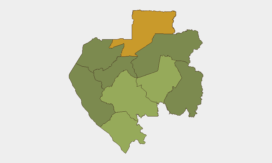
Gabon remains at moderate global risk rank (#49, composite score 43) with no verified security incidents reported in the last 24–48 hours. Current open-source reporting focuses on governance, digital infrastructure, financing, and development initiatives across multiple provinces, with no corroborated incidents of armed conflict, civil unrest, major crime spikes, or travel disruptions. Sub-national risk remains concentrated in the northern border region (Woleu-Ntem Province, risk 72), while the capital and coastal areas present lower operational threat profiles.
Key Developments
- Franceville, Haut-Ogooué – 24 June 2026 – Gabon's national digital infrastructure agency (ANINF) inaugurated a new regional office to extend state digital services and connectivity; no protests, security incidents, or travel disruption reported.
- Libreville – 24 June 2026 – Government conducted its largest sovereign bond issuance since the 2023 coup to rebuild external financing access; macroeconomic focus with no reported political mobilization or security operations tied to the announcement.
- National – 24 June 2026 – World Bank–linked Global Water Security and Sanitation Partnership engagement with Gabon on nationwide water and sanitation expansion; no protests or infrastructure sabotage reported.
- Offshore/Libreville – 24 June 2026 – Ministry of Petroleum signed MoU with Shell and Gabon Oil Company for ultra-deepwater offshore exploration (targeting ~25 million barrels); no militant activity or maritime security incidents reported.
- Southern Gabon (Ndende/Tchibanga axis) – 24 June 2026 – U.S. NGO and military civil-affairs medical support and partnership activities continuing along southern roads and Congo-border communities; no hostility, banditry, or movement restrictions noted.
- National – 24 June 2026 – Banio Potash Project (southern Gabon, U.S. Development Finance Corporation–backed) continues toward feasibility; no recent protests, blockades, or security incidents at project area.
Highest-Risk Areas
Woleu-Ntem Province (risk 72) and Ogooué-Lolo Province (risk 58) dominate the sub-national threat profile, both in Gabon's northern interior and remote border regions. These provinces drive national composite risk through limited state capacity, distance from security and medical infrastructure, cross-border trafficking corridors, and historically sparse reporting density that complicates early warning. Ngounié and Nyanga provinces (risks 48 and 42, respectively) present secondary concern, particularly in their southern and eastern reaches near the Republic of Congo frontier. The capital region (Estuaire Province, risk 15) and southern coastal areas remain considerably lower-risk environments for operations and personnel.
How GeoBit Would Assist
Security teams with operations or personnel in Gabon should deploy AOI Monitoring & Early Warning on Woleu-Ntem and Ogooué-Lolo provinces to track emerging conflict, trafficking, or militia activity with persistent alerting; pair this with multi-language OSINT fusion and X/Twitter sentiment analysis to detect early shifts in local governance or opposition messaging. Routing & Network Analysis and conflict mapping capabilities are essential for planning movement through Ngounié and Nyanga provinces, particularly near Congo borders. Periodic Intel Sweep and global event feeds corroboration will sustain situational awareness against the risk of underreporting in remote areas.
7-Day Outlook
No major disruptions are anticipated over the next week based on current reporting. Governance and economic initiatives are expected to continue without security impediment. However, the concentration of risk in the northern interior warrants sustained monitoring, particularly for any signals of cross-border spillover from regional tensions or trafficking network activity.
Highest-Risk Areas — Ranked
| # | State / Region | Risk |
|---|---|---|
| 1 | Woleu-Ntem | 72 |
| 2 | Ogooué-Lolo Province | 58 |
| 3 | Ngounié Province | 48 |
| 4 | Nyanga Province | 42 |
| 5 | Haut-Ogooué Province | 35 |
| 6 | Moyen-Ogooué Province | 28 |
| 7 | Ogooué-Maritime Province | 25 |
| 8 | Estuaire Province | 15 |
| 9 | Ogooué-Ivindo | 0 |
Sources
Previous Daily Briefs
A new Gabon brief is written every day — each with its own risk map and downloadable CSV. Here's the last week; use the calendar to go further back.
📅 Browse every day by calendar →
Highlighted days have a brief. Tap a day for that day's map & analysis, or “csv” for that day's dataset ($5).