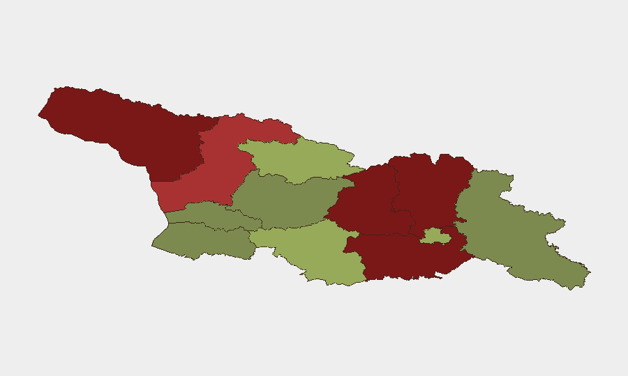
Situation Summary
Georgia remains a relatively low-risk country globally (ranked #100 composite threat score 11), but significant sub-national disparities exist: the disputed territories of Abkhazia and South Ossetia (Shida Kartli, Lower Kartli) carry acute political and military risk, while the capital Tbilisi and western lowland regions present moderate baseline security. A recent magnitude 4.1 earthquake (22 km WNW of Ambrolauri) and active flood event add infrastructure and displacement concerns to the threat environment. No major escalations in the last 24–48 hours have been corroborated from independent sources.
Key Developments
- Earthquake event (recent): M 4.1 seismic event recorded 22 km WNW of Ambrolauri (Racha-Lechkhumi region). Immediate damage and aftershock potential warrant structural assessments in affected zones and regional medical/emergency readiness checks.
- Flood event (recent, location unspecified): Active flooding reported in Georgia; exact location and extent pending further detail. Displacement and infrastructure disruption risks are elevated in low-lying areas; barrier access and supply-chain delays likely.
- No verified civil unrest or security incidents: Searches for current-day (24–48 hour) security, conflict, crime, or civil-unrest incidents in Georgia yielded no corroborated reports from independent wire or regional outlets as of this brief's preparation.
Highest-Risk Areas
Abkhazia (risk 95) and the South Ossetia-adjacent regions of Shida Kartli (88) and Lower Kartli (85) dominate the sub-national threat landscape. These are de facto disputed territories with limited Georgian state authority, ongoing Russian military presence (since 2008 and reinforced post-2014), and cycles of ceasefire violations and diplomatic friction. Mtskheta-Mtianeti (82, highland north-central) and Samegrelo-Upper Svaneti (78, northwest) exhibit elevated risk owing to proximity to conflict zones, terrain complexity, and limited law-enforcement reach. By contrast, Tbilisi (45), Imereti (32), Guria (28), and Adjara (35) remain lower-risk owing to state capacity, economic activity, and tourism infrastructure.
How GeoBit Would Assist
Intel Sweep & OSINT Fusion would establish continuous multi-language monitoring of Georgian Interior Ministry alerts, Tbilisi media (web and social), and disputed-territory messaging to capture early warning of ceasefire breaches or civil disturbances. AOI Monitoring & Early Warning with persistent satellite or signals watch on Abkhazia and South Ossetia would flag military movement, checkpoint activity, or displacement patterns in near-real time. GIS & Spatial Analysis combined with seismic and environmental data would track earthquake aftershocks and flood extent, informing route planning and asset-relocation decisions for operations in Racha-Lechkhumi and other affected zones.
7-Day Outlook
No major escalation is forecast for the next 7 days, but seismic activity and flood impacts will require active infrastructure and supply-chain monitoring, particularly in central and western regions. Abkhazia and South Ossetia remain subject to routine political and military posturing; any uptick in rhetoric or checkpoint incidents would merit rapid escalation review. Personnel and asset managers should maintain standard communication protocols and alternative routing capability in case secondary earthquakes or flooding disrupt transport corridors.
Highest-Risk Areas — Ranked
| # | State / Region | Risk |
|---|---|---|
| 1 | Autonomous Republic of Abkhazia | 95 |
| 2 | Shida Kartli | 88 |
| 3 | Lower Kartli | 85 |
| 4 | Mtskheta-Mtianeti | 82 |
| 5 | Samegrelo-Upper Svaneti | 78 |
| 6 | Samtskhe-Javakheti | 48 |
| 7 | Tbilisi | 45 |
| 8 | Racha-Lechkhumi and Kvemo Svaneti | 42 |
| 9 | Kakheti | 38 |
| 10 | Autonomous Republic of Adjara | 35 |
| 11 | Imereti | 32 |
| 12 | Guria | 28 |
Previous Daily Briefs
A new Georgia brief is written every day — each with its own risk map and downloadable CSV. Here's the last week; use the calendar to go further back.
📅 Browse every day by calendar →
Highlighted days have a brief. Tap a day for that day's map & analysis, or “csv” for that day's dataset ($5).