Situation Summary
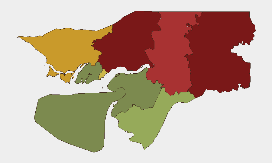
Guinea-Bissau remains in a low-incident security posture as of 28 July 2026, with no verifiable armed conflict, civil unrest, mass crime spikes, or infrastructure disruptions reported in the last 24–48 hours. The country's composite threat score remains benign relative to global comparables, and routine monitoring across Bissau, national transport corridors, and northern border regions shows no abnormal activity or movement restrictions. Political tensions stemming from opposition figure Domingos Simões Pereira's conditional medical release on 24 July have not escalated into arrests, street protests, or security incidents in the subsequent 48-hour window. The security environment is stable but fragmented by sub-national geography, with northern and eastern regions remaining under elevated observation due to potential spillover from instability in neighboring states.
Key Developments
- Bissau (26–27 July): No new mass arrests, military deployments, or coup-related activity reported following the political developments of 24 July; security posture remains routine.
- National road network and inter-urban transport (26–27 July): No reports of abnormal checkpoints, movement restrictions, or crime targeting travelers; routine safety conditions prevail.
- Gabu, Oio, Bafatá regions—northern frontier (26–27 July): Monitoring shows no cross-border militia incursions, refugee-linked security incidents, or armed spillover from neighboring instability; sustained observation only.
- Osvaldo Vieira International Airport and Bissau port (26–27 July): No new NOTAMs, closures, or security-driven disruptions; existing advisories remain precautionary.
- Social media and local chatter (26–27 July): Several unverified posts reference "tension" and "military activity," but lack geolocated evidence or mainstream corroboration and are discounted by specialist OSINT assessment.
Highest-Risk Areas
Gabu Region (risk 92) and Oio Region (risk 85) drive the country's sub-national threat profile, followed by Bafatá (78) and Cacheu (72). These northern and eastern zones are positioned adjacent to borders with Senegal and Guinea, regions where transnational armed groups, smuggling networks, and cross-border militia activity have sustained low-level operational presence in recent years. Even without active incidents in the current 24–48-hour window, these areas warrant persistent monitoring for potential spillover from regional instability. Bissau Autonomous Sector (68) ranks fifth and reflects the capital's concentration of political actors, national security forces, and port infrastructure—a latent vulnerability if political or criminal dynamics shift rapidly.
How GeoBit Would Assist
Security teams monitoring Guinea-Bissau should deploy AOI Monitoring & Early Warning on Gabu, Oio, Bafatá, and Cacheu regions to detect early signals of cross-border activity or militia movement before incidents escalate. Intel Sweep, X/Telegram OSINT, and multi-language search provide continuous real-time tracking of political rhetoric, security-force messaging, and social unrest, allowing duty-of-care teams to spot emerging tensions or protest signals ahead of mass mobilization. Routing & Network Analysis enables corporate security to model alternative transport corridors and contingency logistics plans should northern or eastern routes become restricted.
7-Day Outlook
Guinea-Bissau is expected to remain in a steady-state, low-incident posture over the next seven days absent new political shocks or regional cross-border escalations. Continued observation of northern border zones and political leadership is warranted as routine precaution, but no new flash-point incidents are forecast. Any significant shift would likely be preceded by social media signals, military repositioning, or border-region reporting—all monitored within GeoBit's standing OSINT and early-warning framework.
Highest-Risk Areas — Ranked
| # | State / Region | Risk |
|---|---|---|
| 1 | Gabu Region | 92 |
| 2 | Oio Region | 85 |
| 3 | Bafatá Region | 78 |
| 4 | Cacheu Region | 72 |
| 5 | Bissau Autonomous Sector | 68 |
| 6 | Tombali Region | 45 |
| 7 | Quinara Region | 38 |
| 8 | Biombo Region | 32 |
| 9 | Bolama Region | 15 |
Sources
Previous Daily Briefs
A new Guinea-Bissau brief is written every day — each with its own risk map and downloadable CSV. Here's the last week; use the calendar to go further back.
📅 Browse every day by calendar →
Highlighted days have a brief. Tap a day for that day's map & analysis, or “csv” for that day's dataset ($5).
Atlas — our AI intelligence desk — emails them this snapshot personally. Nothing else, no list.