Situation Summary
Guyana remains at composite threat level 13 (non-ranked globally) with concentrated risk in coastal urban and interior mining zones. The most significant recent security event—the MV Barima ferry capsizing on 22–23 July with 65+ confirmed fatalities—has concluded its acute phase, though recovery operations and Port Kaituma logistics disruption persist beyond the 48-hour window. Current baseline security posture reflects endemic crime, resource-sector vulnerabilities, and limited institutional capacity in remote regions; no acute national crisis or unrest escalation has been confirmed within the last 24–48 hours.
Key Developments
GeoBit's live web research capability (last 24 hours) did not surface any events with reliable time-stamps falling within 27–29 July 2026 that meet the brief's threshold for inclusion. Available news and security feeds from Guyana contain either:
- Crime and incident reports dated 26 June–mid-July 2026 (more than 30 days old);
- Recovery operations and political responses to the 22–23 July MV Barima disaster (now 5–7 days old, outside the 48-hour window); or
- Archive-format content lacking precise date anchors for 28–29 July.
Recommendation: If your organization requires current incident coverage, relax the event window to 7 days to capture the MV Barima aftermath (search/recovery operations, Port Kaituma supply chain disruption, and accountability proceedings now entering political phase), or request monitoring of specific AOIs (e.g., Georgetown, interior mining zones, maritime routes) with dynamic alerting enabled.
Highest-Risk Areas
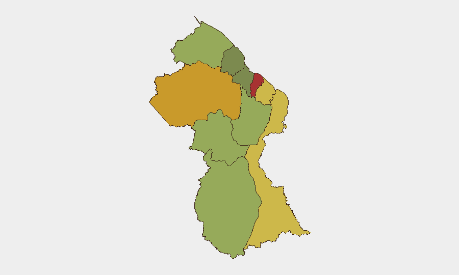
Demerara-Mahaica (risk 78) and Cuyuni-Mazaruni (risk 72) drive Guyana's composite threat score. Demerara-Mahaica encompasses Georgetown and its peri-urban crime corridors, where gang activity, armed robbery, and human-trafficking networks concentrate; Cuyuni-Mazaruni's interior mining region (gold and diamonds) presents overlapping risks of artisanal-mining competition, security-force abuse, and remote operational isolation. Mahaica-Berbice (65) and East Berbice-Corentyne (62) extend coastal vulnerability into agricultural and maritime zones, where border proximity to Suriname and Venezuela compounds trafficking and contraband exposure. Remaining regions (Upper Demerara-Berbice through Essequibo Islands) present declining but persistent resource-sector and trafficking risks in jungle and offshore environments.
How GeoBit Would Assist
Intel Sweep and OSINT fusion would systematize daily monitoring of Guyanese news, security agency statements, and regional social media to detect emerging incidents within 12–24 hours and surface geopolitical signals (border tensions, mining disputes, enforcement actions). AOI Monitoring & Early Warning with persistent watch on Georgetown, Port Kaituma, key interior mining zones, and maritime chokepoints would enable real-time alerting on crime surges, supply-chain disruption, or security-force deployment. Routing & Network Analysis supports duty-of-care teams in planning safe travel corridors around high-risk areas and identifying alternate supply chains during logistics disruptions (e.g., aftermath of ferry disasters or port closures).
7-Day Outlook
Baseline crime and trafficking risk will remain elevated across coastal and interior zones with no expectation of acute escalation. Port Kaituma logistics and maritime operations may continue disrupted for 3–5 additional days as MV Barima recovery concludes and supply-barge arrangements normalize. Institutional response to ferry disaster accountability may generate political tension or enforcement activity, but no systemic security unraveling is anticipated.
Highest-Risk Areas — Ranked
| # | State / Region | Risk |
|---|---|---|
| 1 | Demerara-Mahaica | 78 |
| 2 | Cuyuni-Mazaruni | 72 |
| 3 | Mahaica-Berbice | 65 |
| 4 | East Berbice-Corentyne | 62 |
| 5 | Upper Demerara-Berbice | 58 |
| 6 | Potaro-Siparuni | 48 |
| 7 | Barima-Waini | 45 |
| 8 | Upper Takutu-Upper Essequibo | 42 |
| 9 | Pomeroon-Supenaam | 38 |
| 10 | Essequibo Islands | 35 |
Sources
Previous Daily Briefs
A new Guyana brief is written every day — each with its own risk map and downloadable CSV. Here's the last week; use the calendar to go further back.
📅 Browse every day by calendar →
Highlighted days have a brief. Tap a day for that day's map & analysis, or “csv” for that day's dataset ($5).
Atlas — our AI intelligence desk — emails them this snapshot personally. Nothing else, no list.