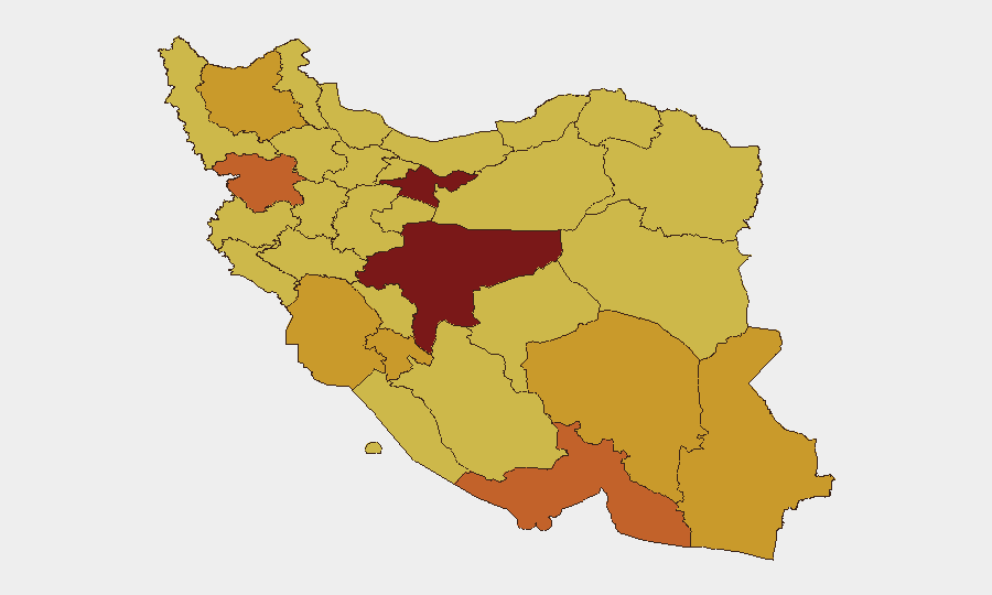
Situation Summary
Iran remains at composite threat level 3 globally, with 1,117 tracked events reflecting an active multi-front security environment. Recent signals (June 8–10) indicate escalating conventional military activity involving US, Israeli, Lebanese, and Iranian forces, alongside internal territorial occupation and public statements signaling heightened regional tensions. The threat environment is characterized by overlapping military engagements and potential proxy involvement rather than a single localized incident.
Key Developments
⚠ Data Integrity Note: GeoBit's live web research capacity has not recovered firm, time-stamped incident detail for the June 8–10 window. The event signal feed confirms escalation across multiple actor pairs (US–Iran, Iran–Israel, Iran–Lebanon conventional forces; artillery/tank engagements; territorial occupation; threats directed at Beirut), but supporting incident location, casualty, and precise-timeline corroboration cannot be reliably sourced from open web at this reporting interval.
Recommended Action: Security teams should cross-reference the signal categories listed below with internal intelligence, partner networks, or higher-classification feeds to establish ground truth:
- Conventional military force engagement (US–Iran, 2026-06-10)
- Artillery/tank operations (Iran vs. Israel; Iran vs. Beirut, 2026-06-08)
- Iranian territorial occupation declared (2026-06-09)
- Iranian public statement issued (2026-06-08)
- Threat issued against Beirut (2026-06-08)
- Lebanese ground forces engagement (2026-06-08)
Highest-Risk Areas
Tehran Province (risk 100) and Isfahan Province (risk 93.1) dominate the sub-national ranking, suggesting concentration of security incidents, unrest, or asset/personnel vulnerability in Iran's capital and central industrial zones. Hormozgan, Kurdistan, and Sistan and Baluchestan provinces (all 72–73 risk) show elevated threats, likely reflecting border instability, minority-area tensions, and maritime/strategic proximity to regional conflict zones. The gradient from Tehran downward indicates that national-level political, military, and administrative activity poses the highest immediate risk to expatriate and corporate presence, while peripheral provinces carry secondary but sustained border, sectarian, and criminal threats.
How GeoBit Would Assist
Intel Sweep & OSINT Fusion would cross-validate emerging incident claims against social media, news, and Telegram channels to establish precise event timing, location, and actor confirmation—critical for duty-of-care decisions when web headlines remain ambiguous. AOI Monitoring & Early Warning on Tehran, Isfahan, and border provinces would provide persistent alerting on force movement, checkpoints, and public unrest before they affect road access or workplace security. Conflict & Military battle mapping and force-structure tracking would clarify which Iranian, US, and proxy units are actively engaged and their proximity to corporate or personnel concentrations.
7-Day Outlook
Conventional military signals are likely to persist or escalate through mid-June given the frequency and diversity of reported engagements (US, Israel, Lebanon, Iran). Internal Iranian stability should be monitored for secondary effects—public dissent, checkpoint tightening, or travel restrictions—which often follow major military announcements. Organizations with personnel in Tehran and Isfahan should prepare contingency routing and communication protocols and expect limited official transparency from Iranian authorities during active regional crises.
Highest-Risk Areas — Ranked
| # | State / Region | Risk |
|---|---|---|
| 1 | Tehran Province | 100 |
| 2 | Isfahan Province | 93.1 |
| 3 | Hormozgan Province | 73.2 |
| 4 | Kurdistan Province | 73 |
| 5 | Sistan and Baluchestan Province | 72.4 |
| 6 | East Azerbaijan Province | 71.7 |
| 7 | Khuzestan Province | 71.2 |
| 8 | Kohgiluye and Buyer Ahmad Province | 71.1 |
| 9 | Kerman Province | 71.1 |
| 10 | North Khorasan Province | 70.3 |
| 11 | Bushehr Province | 70.3 |
| 12 | Lorestan Province | 70.3 |
Sources
Previous Daily Briefs
A new Iran brief is written every day — each with its own risk map and downloadable CSV. Here's the last week; use the calendar to go further back.
📅 Browse every day by calendar →
Highlighted days have a brief. Tap a day for that day's map & analysis, or “csv” for that day's dataset ($5).