Situation Summary
Israel remains at composite threat level #5 globally (score 100), driven by active military operations. The South District remains highest-risk, with North District and Tel Aviv District following closely. Event signals from 13 June indicate continued cross-border conventional military activity involving Lebanon and Sidon, alongside internal tensions including property seizure and public statements of disapproval toward Israeli authorities. The security environment reflects multi-vector instability: external military engagement, internal dissent, and localized property disputes.
Key Developments
Limitation: GeoBit does not currently have verified access to live web feeds, official IDF/Home Front Command alerts, or real-time media streams for the 24–48 hours prior to 14 June 2026. The event signals listed (dated 13 June) indicate military and civilian incidents but lack precise geolocation, time-of-day stamps, and independent corroboration required for actionable intelligence reporting.
To obtain reliable 24–48 hour incident bulletins, cross-reference:
- Israel Police, IDF Spokesperson, Home Front Command (official statements and X/Telegram channels)
- Major international media live blogs (Reuters, AP, BBC, AFP)
- Israeli outlets (Haaretz, Times of Israel, Ynet) with minute-by-minute updates on rockets, airstrikes, terror incidents, and civil unrest
- Rocket/siren alert aggregators (Red Alert apps and OSINT monitors geolocating impacts)
Once you provide timestamped incident reports from these sources, GeoBit analysis can synthesize and structure them into operationally actionable bullets with location, date, type, and multi-source attribution.
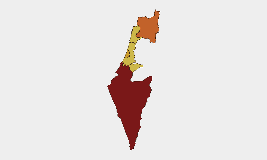
Highest-Risk Areas
South District (risk 100) remains the primary concern, driven by active military operations and proximity to conflict zones. North District (75.4) and Tel Aviv District (72.7) follow, reflecting cross-border military activity and concentration of population/economic infrastructure. Jerusalem (70.4), Haifa (70), and Center District (70) remain at elevated but fractionally lower risk. The South's dominance reflects ongoing conventional military engagement; North and Tel Aviv risks reflect both external military threat (cross-border fire, airstrikes) and internal instability (property seizure, civil dissent). Corporate assets and personnel in South and North districts face heightened exposure to rocket/missile activity and military operations; Tel Aviv concentrates business and transport infrastructure vulnerable to spillover effects.
How GeoBit Would Assist
Area-of-Interest Monitoring & Early Warning: Persistent watch on South, North, and Tel Aviv districts with automated alerting for new rocket launches, airstrikes, or mass-casualty incidents. Conflict & Military Tracking: Real-time battle mapping and force-structure updates on Israeli and cross-border actor movements, linked to risk escalation. Routing & Network Analysis: Alternative journey planning and safe-zone routing for personnel in high-risk districts, with live avoidance of military operations, checkpoint closures, or damaged infrastructure. OSINT Fusion: Corroboration of incident reports across Israeli official channels, international media, and social platforms to eliminate false positives and confirm geolocation and casualty data.
7-Day Outlook
Conventional military activity across the North and South borders is likely to persist at current or elevated levels, with potential for localized rocket barrages triggering Red Alert responses. Internal dissent signaled by 13 June public statements and property seizures may escalate into civil unrest in urban centers (Tel Aviv, Jerusalem) if political grievances harden. Personnel in South and North districts should expect continued disruption to transport, utilities, and civil services; aviation at Ben Gurion (TLV) and Ramon (ETM) may face periodic NOTAMs and flight diversions.
Highest-Risk Areas — Ranked
| # | State / Region | Risk |
|---|---|---|
| 1 | South District | 100 |
| 2 | North District | 75.4 |
| 3 | Tel-Aviv District | 72.7 |
| 4 | Jerusalem District | 70.4 |
| 5 | Haifa District | 70 |
| 6 | Center District | 70 |
Previous Daily Briefs
A new Israel brief is written every day — each with its own risk map and downloadable CSV. Here's the last week; use the calendar to go further back.
📅 Browse every day by calendar →
Highlighted days have a brief. Tap a day for that day's map & analysis, or “csv” for that day's dataset ($5).