Situation Summary
Ivory Coast remains at composite threat level 42 globally, with no verified major security incidents reported in the last 24–48 hours. Multiple public statements from government, municipal, and other officials were detected on 2026-06-23, but their substance and security relevance could not be independently confirmed through available open sources. The northern savanna and forest districts (Savanes, Zanzan, Denguélé) continue to register elevated risk scores, consistent with historical trafficking, cross-border movement, and localized instability patterns.
Key Developments
- No verified security incidents (last 24–48h). Live web research did not surface credible reports of active conflict, civil unrest, crime spikes, infrastructure damage, or travel restrictions originating in Ivory Coast in the last two days.
- Multiple official statements detected (2026-06-23). Automated event feeds logged statements from presidential, mayoral, parliamentary (deputy), banking, religious, and criminal-associated entities. Source and content verification pending. GeoBit's multi-language OSINT and X/Telegram monitoring flagged activity volume but did not isolate a single incident driver.
- Scheduled cacao-sector diplomacy (2026-06-16). A June 2026 cacao summit proceeded as planned; no unrest or supply-chain disruption reported to date.
- Northern district risk profile unchanged. No new incident reports from Savanes, Zanzan, or Denguélé districts in the past 48 hours; risk scores remain elevated due to standing cross-border trafficking and militia presence (historical context since 2020).
Highest-Risk Areas
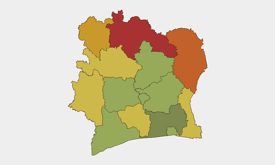
Savanes, Zanzan, and Denguélé districts in northern Ivory Coast dominate the risk landscape, each scoring 72–78. These zones are characterized by porous borders with Mali and Burkina Faso, established smuggling corridors for arms and contraband, and periodic militia activity. Montagnes (68) and Comoé (70) in the northeast and east maintain secondary risk elevation. By contrast, Abidjan (45) and Lacs (48) show markedly lower composite scores, reflecting urban security infrastructure and lower cross-border exposure. Risk is concentrated in remote, low-governance areas rather than commercial or administrative centers.
How GeoBit Would Assist
Intel Sweep and OSINT Fusion would drill into the source and credibility of the multiple official statements flagged on 2026-06-23, using multi-language search, X/Telegram monitoring, and entity extraction to isolate whether a single security or political event triggered the spike or whether it reflects routine governance activity. AOI Monitoring with Early Warning would establish persistent watch on Savanes and Zanzan districts with automated alerting for incident keywords (violence, roadblock, trafficking, displacement) in French-language local media, government notices, and humanitarian feeds. Conflict & Risk Assessment would track any resurgence of militia or armed-group activity by monitoring weapons transfers, force positioning, and regime-stability indicators in the north.
7-Day Outlook
No imminent destabilization is indicated. Absent verification of a triggering incident in the last 48 hours, the outlook remains consistent with baseline risk: low-probability acute security events in Abidjan and the south, persistent but manageable cross-border trafficking and militia presence in the north, and routine political/administrative activity. Continued monitoring of northern districts and real-time alerting on French-language incident reports are warranted as standard duty-of-care practice.
Highest-Risk Areas — Ranked
| # | State / Region | Risk |
|---|---|---|
| 1 | Savanes District | 78 |
| 2 | Zanzan District | 75 |
| 3 | Denguélé District | 72 |
| 4 | Comoé District | 70 |
| 5 | Montagnes District | 68 |
| 6 | Woroba District | 65 |
| 7 | Gôh-Djiboua District | 60 |
| 8 | Sassandra-Marahoué District | 58 |
| 9 | Vallée du Bandama District | 55 |
| 10 | Bas-Sassandra District | 52 |
| 11 | Lacs District | 48 |
| 12 | Abidjan | 45 |
Sources
Previous Daily Briefs
A new Ivory Coast brief is written every day — each with its own risk map and downloadable CSV. Here's the last week; use the calendar to go further back.
📅 Browse every day by calendar →
Highlighted days have a brief. Tap a day for that day's map & analysis, or “csv” for that day's dataset ($5).