Situation Summary
Lebanon remains at composite threat level #11 globally (99.9 score) amid escalating Israeli-Lebanese cross-border military operations and strikes on UN positions in the south. Since early June, a marked surge in projectile exchanges, airstrikes in southern Beirut and the Beqaa, and attacks on UNIFIL installations signals a critical deterioration from the April ceasefire baseline. Mass displacement is underway in southern Lebanon, with hundreds of thousands affected by Israeli evacuation orders, and four UN peacekeepers have been injured in 40–48 hours of strikes on multiple UNIFIL positions.
Key Developments
- Naqoura, UNIFIL Headquarters (South Lebanon) – Friday, 5 June 2026
Explosions struck the UN peacekeeping mission's main headquarters for the second time in 48 hours, injuring at least two peacekeepers, one with serious abdominal shrapnel wounds. UNIFIL spokesperson confirmed four peacekeepers injured across multiple positions in the last 40–48 hours.
- UNIFIL Positions, Southern Lebanon (multiple sites) – Thursday–Friday, 4–5 June 2026
Three UNIFIL positions were struck on Thursday; one strike confirmed at headquarters on Friday, indicating a sustained pattern of fire on UN installations.
- Southern Lebanon, North of Litani River – Wednesday–Thursday, 3–4 June 2026
UNIFIL recorded approximately 670 projectile movements on Wednesday—the highest single-day count since the April ceasefire. Israeli ground and air operations, including armored vehicle movements and airstrikes north of the Litani, were documented in parallel UN News briefing.
- South Lebanon, Zahrani River Area – Prior 48 Hours, by Thursday, 4 June 2026
Israeli evacuation orders triggered new mass displacement affecting hundreds of thousands. Collective shelters in Tyre and Saida are now filling, according to UN OCHA reporting.
- Southern Beirut and South Lebanon – By Thursday, 4 June 2026
The UN expressed "deep concern" over intensified Israeli airstrikes in southern Beirut and southern Lebanon, indicating a shift of air operations into urban residential zones and raising civilian casualty risk.
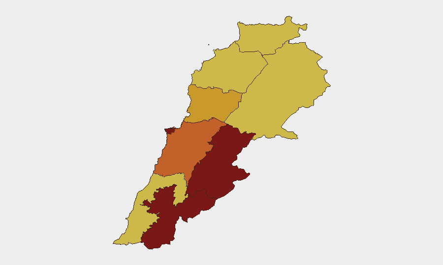
Highest-Risk Areas
Beqaa Governorate (99.9 risk), Nabatieh (94.5), and Beirut (91.1) dominate the sub-national ranking. Beqaa's position as the primary weapons-transfer corridor and militia stronghold, combined with recent heavy air activity, explains its critical score. Nabatieh and the southern zone face the direct Israeli military operations and displacement. Beirut's 91.1 score reflects proximity to southern suburbs (militant infrastructure) and ongoing vulnerability to airstrikes. Mount Lebanon and Keserwan-Jbeil remain elevated but less acute than the southern and eastern borders.
How GeoBit Would Assist
Security and duty-of-care teams should deploy AOI Monitoring & Early Warning on Beqaa Governorate, southern Lebanon crossing zones, and Beirut southern suburbs to capture projectile patterns and airstrikes in near-real-time. GIS & Spatial Analysis and Satellite Imagery tracking enable mapping of displacement corridors, UNIFIL position vulnerability, and safe routing around active conflict zones. Conflict & Military force-structure and weapons-capability tracking, combined with Network & Actor Analysis of Lebanese militia and Israeli command signals, provide forward indicators of operation tempo and ceasefire stability.
7-Day Outlook
Projectile and air activity is likely to remain elevated or spike further over the next 7 days if diplomatic de-escalation does not materialize. Displacement will continue to strain southern Lebanon's humanitarian capacity. UNIFIL casualty risk remains acute unless strike patterns abate. Organizations with personnel or assets in Beqaa, Nabatieh, southern Beirut, or southern Lebanon should assume operational constraints and activate contingency routing and evacuation protocols.
Highest-Risk Areas — Ranked
| # | State / Region | Risk |
|---|---|---|
| 1 | Beqaa Governorate | 99.9 |
| 2 | Nabatieh Governorate | 94.5 |
| 3 | Beirut Governorate | 91.1 |
| 4 | Mount Lebanon Governorate | 73 |
| 5 | Keserwan-Jbeil Governorate | 71.5 |
| 6 | South Governorate | 70.1 |
| 7 | North Governorate | 69.9 |
| 8 | Akkar Governorate | 69.9 |
| 9 | Baalbek-Hermel Governorate | 69.9 |
Previous Daily Briefs
A new Lebanon brief is written every day — each with its own risk map and downloadable CSV. Here's the last week; use the calendar to go further back.
📅 Browse every day by calendar →
Highlighted days have a brief. Tap a day for that day's map & analysis, or “csv” for that day's dataset ($5).