Situation Summary
Liberia remains a low-threat environment globally (rank #126, composite score 7) with no active conflict or widespread civil unrest, but faces elevated organized-crime and infrastructure vulnerabilities concentrated in border regions and key transport nodes. Recent high-profile drug seizures and corruption disclosures at Roberts International Airport signal that Liberia continues to function as a transit corridor for transnational trafficking, with active attempts to compromise security personnel and critical infrastructure. Seasonal flooding in Monrovia presents concurrent civil-protection risks. The security trajectory is stable but fragile, dependent on sustained law-enforcement action against corruption and trafficking networks.
Key Developments
- Roberts International Airport (RIA), Margibi County – 6 July 2026: Liberia National Police Inspector General Gregory O.W. Coleman formally charged seven suspects, including Global Logistics Services (GLS) and Operations Manager Paul J. King, in connection with a US$19.2 million cocaine seizure (237.6 kg); investigators disclosed evidence that trafficking networks attempted to bribe security personnel and interfere with seizure recovery, raising acute corruption risk at Liberia's primary international gateway.
- Monrovia, Montserrado County – 6 July 2026: A 12-member jury at Criminal Court "A" convicted Arthur Chan‑Chan, a former National Security Agency (NSA) agent, of human trafficking and visa fraud valued at US$100,000, marking a significant organized-crime prosecution involving a compromised intelligence official and signaling insider-threat vulnerabilities in state security apparatus.
- Unspecified location, Liberia Drug Enforcement Agency jurisdiction – 6 July 2026: The LDEA arrested a 46-year-old Nigerian national and seized narcotics valued at more than L$296,000, consistent with patterns of foreign actors operating in Liberia's drug distribution market.
- Monrovia and surrounding communities – early July 2026 (ongoing): Ministry of Public Works and disaster-management officials warned of heightened flooding and infrastructure risk following heavy rainfall during peak rainy season, threatening roads, drainage, and low-lying residential areas in the capital and outlying zones.
Highest-Risk Areas
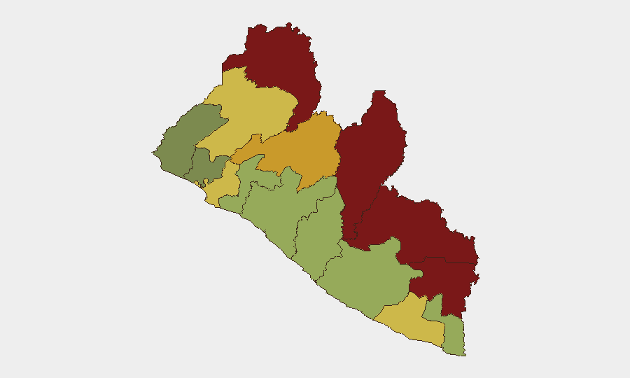
Nimba, Lofa, and Grand Gedeh counties (scores 92, 88, 85 respectively) dominate sub-national risk, reflecting endemic cross-border trafficking, weak state presence, and limited law-enforcement capacity in Liberia's eastern and northern frontier zones bordering Guinea, Sierra Leone, and Côte d'Ivoire. Montserrado County (score 64)—home to Monrovia and RIA—ranks eighth but drives national operational risk because it concentrates government, commerce, and international transport, making corruption or security breaches there strategically consequential for national and expatriate populations. Margibi County (score 52), containing RIA and key logistics nodes, has become a focal point for trafficking interdiction and corruption risk, as evidenced by the current cocaine case.
How GeoBit Would Assist
Teams managing personnel or assets in Liberia should deploy AOI Monitoring & Early Warning capabilities to track RIA, key road corridors, and Montserrado County for trafficking incidents, security compromises, and infrastructure failures; complement with Intel Sweep and OSINT fusion to surface court filings, police disclosures, and media reporting on organized-crime prosecutions and corruption. Network & Actor Analysis would map trafficking and corruption networks involving port, airport, and security officials to enable targeted due-diligence and insider-threat assessment. Environmental & Health monitoring should track seasonal flooding risk in Monrovia to support travel and logistics planning.
7-Day Outlook
No major escalation is anticipated. Ongoing criminal proceedings against trafficking suspects and compromised officials will likely continue; police and LDEA operations may yield additional seizures or arrests as investigations expand. Monrovia flooding risk will persist through the rainy season, requiring adaptive logistics and travel protocols.
Highest-Risk Areas — Ranked
| # | State / Region | Risk |
|---|---|---|
| 1 | Nimba County | 92 |
| 2 | Lofa County | 88 |
| 3 | Grand Gedeh County | 85 |
| 4 | River Gee County | 83 |
| 5 | Bong County | 72 |
| 6 | Gbarpolu County | 68 |
| 7 | Grand Kru County | 65 |
| 8 | Montserrado County | 64 |
| 9 | Rivercess County | 58 |
| 10 | Sinoe County | 55 |
| 11 | Margibi County | 52 |
| 12 | Grand Bassa County | 48 |
Sources
Previous Daily Briefs
A new Liberia brief is written every day — each with its own risk map and downloadable CSV. Here's the last week; use the calendar to go further back.
📅 Browse every day by calendar →
Highlighted days have a brief. Tap a day for that day's map & analysis, or “csv” for that day's dataset ($5).
Atlas — our AI intelligence desk — emails them this snapshot personally. Nothing else, no list.