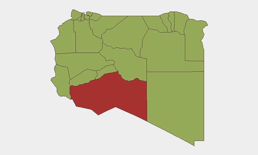
Situation Summary
Libya remains at moderate global threat rank (#24, composite score 67.3) with 17 tracked events over the reporting window. The security environment is characterized by persistent fragmentation across sub-national zones, with Murzuq emerging as the single highest-risk area (77.1), while ten other regions cluster at elevated but near-equal risk (47.1 each). Recent signals include arrest and detention activity, rejection statements from state and non-state actors, blockade operations affecting the Secretariat, and small-arms combat involving Turkish actors as of 10 June. The trajectory suggests continued localized instability without indicators of imminent nationwide escalation.
Key Developments
Note: GeoBit's open-source research capability identified signals classified by event type and date (10–11 June 2026) but lacked independent, time-stamped corroboration for specific incident locations and circumstances. The following are flagged by the platform pending verification through professional real-time threat feeds:
- Arrest/Detention (11 June): Authorities detained a lawyer; authorities also conducted detention activity linked to Libya. Circumstances and jurisdiction unclear pending field corroboration.
- Blockade (11 June): Secretariat-level operations reported; scope and actors require clarification.
- Small-Arms Combat (10 June): Turkish actors engaged in combat; geographic epicenter not yet pinpointed in available open reporting.
- Rejection Statements (10–11 June): Multiple rejection declarations from Libyan, Mauritanian, and banking actors; motivations and diplomatic/commercial implications under analysis.
- Investigative Activity (9 June): Filipino vs. worker investigation initiated; labor or security context unclear.
- Public Statements (11 June): Actor and Ana Maria issued public statements; content and policy implications pending review.
Corporate teams should note: These signals lack the temporal precision and independent sourcing required for tactical decision-making. Engagement with professional threat-intelligence platforms (Crisis24, GardaWorld, ACLED, Dataminr) and direct liaison with UNSMIL and Libya Observer newsroom is strongly recommended before operational response.
Highest-Risk Areas
Murzuq (77.1) significantly outpaces all other tracked zones and warrants concentrated monitoring. Its isolation, historical role in trafficking networks, and weak state presence create persistent ungoverned-space vulnerabilities. The ten-region tier at 47.1—including Tripoli, Zawiya, Kufra, Nalut, and Ghat—indicates diffuse rather than concentrated risk; no single secondary zone dominates. Tripoli's inclusion reflects capital-level political tension and administrative friction. Border regions (Nalut, Ghat, Kufra) signal cross-border movement and sanctions-evasion activity. Zawiya and Surman proximity to the coast implies maritime trafficking and petroleum-sector contestation. The clustering suggests Libya's fragmentation is managed rather than collapsing, but corporate presence in any of these zones carries baseline-elevated exposure.
How GeoBit Would Assist
Intelligence teams would deploy *AOI (Area-of-Interest) Monitoring & Early Warning* with persistent watch on Murzuq, Zawiya, and Tripoli to detect escalation signals before they reach mainstream media. *Intel Sweep* (global event feeds, multi-language OSINT, entity extraction) combined with *Network & Actor Analysis* would map arrest patterns, blockade actors, and Turkish force presence. *Conflict & Military* battle-mapping and *GIS & Spatial Analysis* would plot small-arms incidents and establish safe routing. *Regime-Stability Search* would contextualize rejection statements and detention policy shifts.
7-Day Outlook
No indicators suggest imminent nationwide escalation or major capital-city disruption in the next seven days. Murzuq remains the focal point of instability; continued low-level detention, rejection diplomacy, and localized combat should be expected. Corporate movements, visa processing, and supply-chain continuity are unlikely to face systemic obstacles unless Turkish involvement or Secretariat-level blockade expands geographically.
Highest-Risk Areas — Ranked
| # | State / Region | Risk |
|---|---|---|
| 1 | Murzuq | 77.1 |
| 2 | Nalut | 47.1 |
| 3 | Ghat | 47.1 |
| 4 | Baladiyah Surman | 47.1 |
| 5 | Az Zawiya District | 47.1 |
| 6 | Wadi al Shatii | 47.1 |
| 7 | Wadi al Hayaa | 47.1 |
| 8 | Kufra | 47.1 |
| 9 | Nuqat al Khams | 47.1 |
| 10 | Tripoli | 47.1 |
| 11 | Jafara | 47.1 |
| 12 | Murqub | 47.1 |
Sources
Previous Daily Briefs
A new Libya brief is written every day — each with its own risk map and downloadable CSV. Here's the last week; use the calendar to go further back.
📅 Browse every day by calendar →
Highlighted days have a brief. Tap a day for that day's map & analysis, or “csv” for that day's dataset ($5).