Situation Summary
Lithuania remains under heightened security posture following Russian statements on 22 July and sustained intelligence warnings of potential hybrid or kinetic provocations against Baltic critical infrastructure. No major attacks, mass civil unrest, or successful breaches have occurred in the past 24–48 hours; daily life and commercial movement continue largely unimpeded. Border pressure persists with 13 illegal crossing attempts from Belarus intercepted on 23 July, but these remain within routine operational parameters. The threat trajectory is one of sustained elevated vigilance rather than imminent escalation.
Key Developments
- Lithuania–Belarus border (multiple crossing points), 23 July 2026 – Lithuanian border guards prevented 13 illegal crossing attempts from Belarus over the preceding 24 hours, consistent with ongoing hybrid-pressure patterns; no mass breach or associated civil unrest reported.
- Klaipėda LNG terminal and wider critical energy infrastructure, ongoing 19 July–19 August – Lithuanian Armed Forces remain actively deployed to protect the LNG facility, electricity substations (including Alytus LitPol Link site and Kruonis Pumped Storage Hydroelectric Plant), and communications hubs under a formal Defence Ministry protection order citing intelligence on possible Russian sabotage or hybrid-attack scenarios.
- National critical-infrastructure security extension, 22–23 July – The Defence Ministry confirmed that enhanced military and Public Security Service guard presence at bridges, substations, gas infrastructure, and communications hubs will remain indefinitely, reflecting persistent threat assessment rather than imminent tactical escalation.
- Presidential national security statement, 21–23 July – Senior advisers stated no direct conventional military threat exists at present but underscored the focus on hybrid and provocational scenarios; no travel bans, curfews, or emergency-level restrictions were announced.
- NATO coordination readiness, 21–23 July – Presidential advisers reiterated NATO's prepared capacity to rapidly deploy additional air-defense and troop assets to Lithuania if threat indicators reach "critical" levels, but no new deployments have been activated in the monitored period.
Highest-Risk Areas
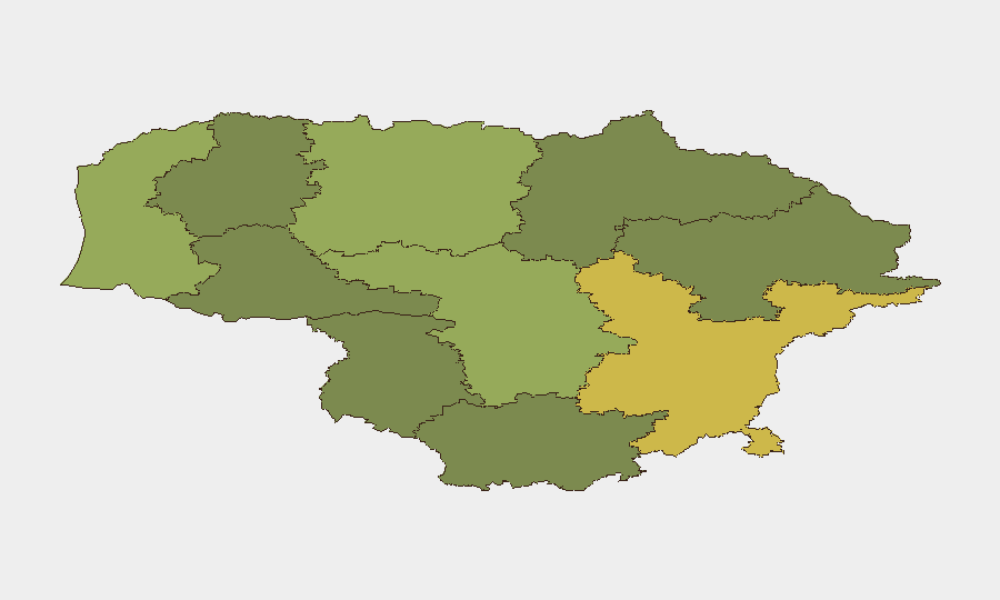
Vilnius County (risk 68) and Kaunas County (risk 58) drive the national risk profile, primarily reflecting critical-infrastructure concentration (energy, communications, government facilities) and population density in and around the capital and second-largest city. Klaipėda County (risk 52) ranks third due to its strategic role as Lithuania's only deep-water port and host to the LNG terminal—a key NATO-aligned energy asset and stated target in Russian threat narratives since February. These three counties account for the majority of national economic output and government functions; disruption to any would carry disproportionate national and regional consequences. Border counties (Taurage, Utena, Alytus, Telšiai, Marijampolė) remain lower-risk, reflecting lower population density and fewer critical strategic assets, though they are subject to continued migratory and hybrid-pressure monitoring.
How GeoBit Would Assist
Intel Sweep and X/Twitter & multi-language OSINT provide real-time monitoring of Russian statements, military posturing, and hybrid-threat signaling. AOI Monitoring & Early Warning with persistent watch on critical-infrastructure sites (LNG terminal, power substations, border crossing points) and GIS & Spatial Analysis enable rapid detection of anomalies, unauthorized activity, or environmental changes. Routing & Network Analysis supports alternative journey and supply-chain planning for personnel and assets in high-risk counties, while conflict and maritime tracking maintain awareness of Baltic military posture and potential choke-point vulnerabilities.
7-Day Outlook
No indicators suggest imminent conventional escalation; the current posture is likely to persist through late July. Monitoring should focus on Russian statements, NATO deployment notifications, and any changes to border-crossing activity or critical-infrastructure incidents. Election-related risk factors and hybrid-provocation scenarios remain the primary near-term drivers of Lithuanian government alert status.
Highest-Risk Areas — Ranked
| # | State / Region | Risk |
|---|---|---|
| 1 | Vilnius County | 68 |
| 2 | Kaunas County | 58 |
| 3 | Klaipeda County | 52 |
| 4 | Siauliai County | 42 |
| 5 | Panevezys County | 38 |
| 6 | Taurage County | 35 |
| 7 | Utena County | 33 |
| 8 | Alytus County | 32 |
| 9 | Telsiai County | 28 |
| 10 | Marijampole County | 25 |
Previous Daily Briefs
A new Lithuania brief is written every day — each with its own risk map and downloadable CSV. Here's the last week; use the calendar to go further back.
📅 Browse every day by calendar →
Highlighted days have a brief. Tap a day for that day's map & analysis, or “csv” for that day's dataset ($5).
Atlas — our AI intelligence desk — emails them this snapshot personally. Nothing else, no list.