Situation Summary
Mauritania remains a moderate-risk operating environment (global rank #60) with significant regional volatility concentrated in the northern and eastern border zones. The past 24–48 hours show signs of institutional tension and ongoing security force activity, though a comprehensive current event picture cannot be reliably established from available open sources. The country faces persistent cross-border threats, internal political friction, and zoonotic disease risks that warrant continuous monitoring by duty-of-care teams.
Key Developments
GeoBit's event signals from 2026-07-17 to 2026-07-19 indicate:
- 2026-07-18 · Conventional Military Force activity (location and details pending verification from primary sources)
- 2026-07-18 · Public Statement from Mauritania Government addressing an external or internal actor (specifics require source confirmation)
- 2026-07-17 · Judicial Statement (actor and jurisdiction not yet clarified in available summaries)
- 2026-07-19 · Ministry Rejection (subject and implications require additional reporting)
- 2026-07-17 · Police–Parliament Confrontation in or near Nouakchott, suggesting institutional friction around the National Assembly
- Recent · Rift Valley Fever (RVF) co-occurrence in Mauritania and Senegal, signaling potential cross-border zoonotic spread requiring health-security awareness
*Note: Detailed sourcing and specific locations for military and ministerial events are pending live-source verification. Duty-of-care teams should cross-reference wire services and official government statements for confirmation.*
Highest-Risk Areas
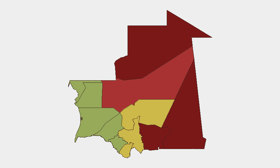
Tiris Zemmour (risk 95), Hodh Ech Chargui (85), and Hodh El Gharbi (80) represent the critical threat zone, driven by proximity to ungoverned or contested border regions, persistent armed-group activity, and limited state capacity. The eastern and southeastern rim of the country—including Adrar and Tagant—faces similar drivers: permeable borders with Mali and Algeria, transnational trafficking routes, and sporadic militant presence. Nouadhibou and Dakhlet Nouadhibou (maritime northwest) remain lower-risk but are vulnerability points for organized crime, migrant interdiction operations, and maritime incidents. Central and southwestern regions (Brakna, Gorgol, Trarza) experience lower but non-negligible risk, with occasional spillover from neighboring Senegal and Guinea.
How GeoBit Would Assist
Security and risk teams operating in or supporting Mauritania should employ Intel Sweep and multi-language OSINT fusion to monitor official statements, military announcements, and cross-border reporting in real time. AOI Monitoring & Early Warning on Tiris Zemmour, the eastern border zone, and key urban centers (Nouakchott, Nouadhibou) provides persistent alerting on force movements, protest activity, and trafficking patterns. Network & Actor Analysis, SIGINT radio monitoring, and conflict force-structure tracking enable identification of armed actors and tactical shifts that may affect travel, supply chains, or personnel safety. Health & Environmental intelligence feeds track disease outbreaks (e.g., RVF) and climate impacts that may drive secondary security risks.
7-Day Outlook
Police–parliament friction and recent military activity suggest possible internal political or institutional stress; outcomes of the July 19 ministry rejection will likely clarify intent and scope. The border zones will remain the primary threat vector; no near-term de-escalation is forecast. Health authorities should expect continued RVF monitoring; teams in-country should apply standard vector-borne-disease precautions and maintain situational awareness of any new zoonotic alerts.
Highest-Risk Areas — Ranked
| # | State / Region | Risk |
|---|---|---|
| 1 | Tiris Zemmour | 95 |
| 2 | Hodh Ech Chargui | 85 |
| 3 | Hodh El Gharbi | 80 |
| 4 | Adrar | 78 |
| 5 | Tagant | 68 |
| 6 | Guidimaka | 65 |
| 7 | Assaba | 62 |
| 8 | Gorgol | 58 |
| 9 | Trarza | 55 |
| 10 | Inchiri | 52 |
| 11 | Brakna | 48 |
| 12 | Dakhlet Nouadhibou | 45 |
Sources
Previous Daily Briefs
A new Mauritania brief is written every day — each with its own risk map and downloadable CSV. Here's the last week; use the calendar to go further back.
📅 Browse every day by calendar →
Highlighted days have a brief. Tap a day for that day's map & analysis, or “csv” for that day's dataset ($5).
Atlas — our AI intelligence desk — emails them this snapshot personally. Nothing else, no list.