Situation Summary
Mexico remains the second-highest global threat environment (composite score 100) driven principally by ongoing insurgency and organized crime violence across 12 high-risk states. A nationwide security mobilization of over 100,000 personnel is currently active, concentrated in World Cup host cities and major tourist corridors, reflecting elevated operational tempo and federal acknowledgment of sustained cartel and criminal activity. The threat landscape shows no significant de-escalation; deployments are reactive containment measures rather than indicators of underlying risk reduction.
Key Developments
- Nahuatzen, Michoacán (12 June): Five municipal police officers killed and five wounded in cartel-linked ambush in Indigenous region; incident occurred in cartel-contested territory ahead of World Cup matches.
- Guadalajara, Jalisco (13–14 June): Significant increase in National Guard and police patrols, including vehicle-mounted weapons and crowd-control units, deployed around stadium and key venues in response to earlier cartel violence and U.S. Embassy security warnings.
- Mexico City – Federal Security Operation (13–14 June): Nationwide 100,000-person deployment now active in capital, including anti-drone teams, surveillance networks, and reinforced National Guard presence in central districts and tourist corridors; U.S. Embassy reiterates increased-caution advisory for crime and potential targeting of visitors.
- Monterrey, Nuevo León (13–14 June): State police and Guardia Nacional patrols intensified on highways 85/85D, 54, and 40/40D following updated U.S. travel warnings of armed robberies, carjackings, and kidnapping threats on these corridors, particularly after dark.
- Tijuana and Tecate, Baja California (14 June): UK FCDO maintains "advise against all but essential travel" designation; recent reports from local media and residents cite shootings and road blockades in eastern Tijuana neighborhoods within last 24–48 hours.
- Chiapas Border Region (13–14 June): UK FCDO advisory confirms continued restrictions on travel within 40 km of Guatemala border and Federal Highway 199; local accounts report intermittent road closures and armed-group presence on rural highway stretches.
- Cancún International Airport, Quintana Roo (11–14 June): Teachers' union protests anticipated 11 June; residual police and security presence continues on airport access roads, causing periodic traffic slowdowns through 14 June.
Highest-Risk Areas
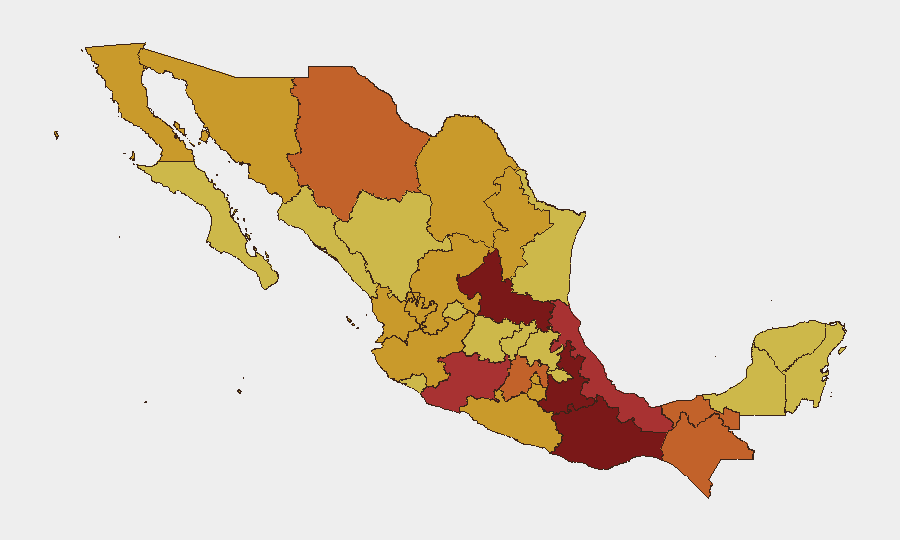
San Luis Potosí (risk 100), Puebla (96.9), and Oaxaca (85.8) lead the sub-national rankings, with Michoacán, Veracruz, and Tabasco forming a contiguous high-risk corridor in western and central Mexico. These states reflect concentrated cartel territorial control, ongoing turf conflicts, and weak institutional capacity to contain organized violence. The Baja California border region and Chiapas-Guatemala frontier also remain elevated due to smuggling networks, transnational criminal activity, and sporadic armed confrontation. Risk concentration in these corridors indicates predictable geographic exposure for corporate operations, supply chains, and personnel transiting these regions.
How GeoBit Would Assist
Security teams should deploy AOI Monitoring & Early Warning on San Luis Potosí, Michoacán, and the Monterrey-Nuevo Laredo corridor to detect roadside incidents, cartel activity surges, and checkpoint changes in real time. Routing & Network Analysis would identify secure alternative routes and timing strategies for personnel and asset movement, cross-referencing live OSINT feeds (X, Telegram, local media) to avoid active violence hotspots. Risk & Threat Assessment combined with event-feed analysis enables weekly threshold monitoring of police attacks, territorial occupation claims, and government deployments—triggering duty-of-care escalations when composite indicators shift.
7-Day Outlook
The World Cup security operation will sustain heightened federal and local deployments through the tournament's duration, likely suppressing large-scale cartel confrontations in host cities but not altering underlying territorial disputes or highway corridor risks. Michoacán, border states, and Chiapas will remain persistent threat zones; personnel and asset exposure in these regions should be reassessed under current incident velocity and institutional capacity constraints.
Highest-Risk Areas — Ranked
| # | State / Region | Risk |
|---|---|---|
| 1 | San Luis Potosí | 100 |
| 2 | Puebla | 96.9 |
| 3 | Oaxaca | 85.8 |
| 4 | Michoacán | 79 |
| 5 | Veracruz | 77.6 |
| 6 | Tabasco | 75.7 |
| 7 | State of Mexico | 73.6 |
| 8 | Chihuahua | 73 |
| 9 | Chiapas | 73 |
| 10 | Baja California | 72.6 |
| 11 | Sonora | 72.4 |
| 12 | Zacatecas | 72.4 |
Previous Daily Briefs
A new Mexico brief is written every day — each with its own risk map and downloadable CSV. Here's the last week; use the calendar to go further back.
📅 Browse every day by calendar →
Highlighted days have a brief. Tap a day for that day's map & analysis, or “csv” for that day's dataset ($5).