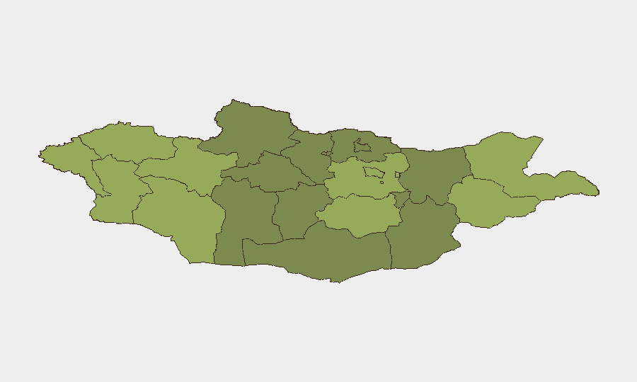
Situation Summary
Mongolia presents a low overall security threat (global rank #null; composite score 21) with no major civil unrest, political instability, or confirmed new incidents in the last 24–48 hours. The primary near-term hazards are environmental—active flood warnings across central and eastern provinces with water levels already above danger thresholds—and a reported violent crime incident involving Israeli travelers (date/location unconfirmed in open sources). Baseline risk remains manageable for corporate operations in Ulaanbaatar and southern regions, but border areas and river-adjacent travel require heightened caution through at least mid-July.
Key Developments
- Central and Eastern Mongolia – 2026-07-17 onward: Mongolia's meteorology and emergency agencies issued a flood watch for multiple rivers with water levels above danger marks and forecasts for further rise. Residents and travelers advised to avoid riverbanks and swollen water crossings.
- Tuul and Kherlen Rivers – ongoing, mid-July 2026: Local authorities maintain active warnings on both river systems. High water and flooding risk persist; infrastructure (bridges, roads) in adjacent areas remain under pressure and subject to potential closure or damage.
- Unspecified Mongolia campsite – July 2026 (date/location not timestamped in open reporting): A security incident involving Israeli travelers resulted in at least one fractured jaw; the group reportedly departed with embassy assistance. Violent crime against foreign tourists remains a documented concern.
- Nationwide – summer 2026: Mongolia's National Center for Zoonotic Diseases flagged 17 of 21 provinces at risk for bubonic plague, particularly affecting rural areas and individuals engaged in illegal marmot hunting. Public health hazard with implications for remote corporate operations and field teams.
- General compliance – July 2026: Australia's Smartraveller and routine advisories remind foreign nationals of mandatory registration with the Mongolian Immigration Agency within 48 hours of arrival. No elevated threat noted, but administrative compliance remains essential for duty-of-care purposes.
Highest-Risk Areas
Dornod and Sükhbaatar (risk scores 58 and 55 respectively) dominate the eastern border region and drive Mongolia's sub-national risk profile, likely reflecting proximity to disputed or sensitive territorial zones and cross-border activity. Uvs, Khovd, and Bayan-Ölgii in the west (scores 52–48) present secondary risk clusters, possibly related to remote terrain, pastoralist populations, and limited state presence. Ulaanbaatar (score 45) remains the mid-tier risk hub for urban crime and transient threats, while southern provinces (Ömnögovi, Dundgovi) and central regions show lower but non-negligible risk. Organizations with assets in Dornod or Sükhbaatar should implement heightened monitoring and contingency protocols.
How GeoBit Would Assist
Real-time AOI (Area of Interest) Monitoring & Early Warning on flood-prone river valleys and border provinces would detect changes in water levels, road closures, and population movement before traditional channels report them. OSINT Fusion & Corroboration across Mongolian-language media, X/Twitter, and humanitarian feeds would rapidly surface new incidents—violent crime, disease cases, or civil unrest—and time-stamp them for operational decision-making. Routing & Network Analysis would enable security teams to identify alternate transport corridors avoiding flooded zones and high-risk border areas in real-time, protecting field teams and supply chains.
7-Day Outlook
Flood risk will likely persist through late July as seasonal runoff continues; river-adjacent provinces should remain under travel restriction until water levels normalize. No significant uptick in civil unrest or organized crime is forecast. Bubonic plague warnings will remain in effect for rural areas; occupational health protocols for field staff should remain active.
Highest-Risk Areas — Ranked
| # | State / Region | Risk |
|---|---|---|
| 1 | Dornod | 58 |
| 2 | Sükhbaatar | 55 |
| 3 | Uvs | 52 |
| 4 | Khovd | 50 |
| 5 | Bayan-Ölgii | 48 |
| 6 | Govi-Altai | 46 |
| 7 | Ulaanbaatar | 45 |
| 8 | Zavkhan | 44 |
| 9 | Töv | 42 |
| 10 | Dundgovi | 40 |
| 11 | Darkhan-Uul | 38 |
| 12 | Ömnögovi | 37 |
Sources
Previous Daily Briefs
A new Mongolia brief is written every day — each with its own risk map and downloadable CSV. Here's the last week; use the calendar to go further back.
📅 Browse every day by calendar →
Highlighted days have a brief. Tap a day for that day's map & analysis, or “csv” for that day's dataset ($5).
Atlas — our AI intelligence desk — emails them this snapshot personally. Nothing else, no list.