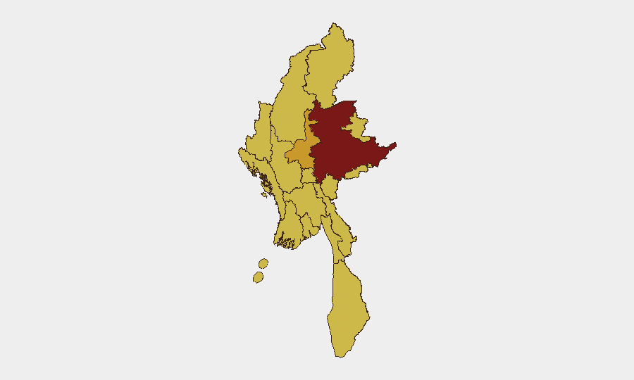
Situation Summary
Myanmar remains in active civil war with composite threat score 100 (rank #10 globally), driven by sustained conventional military operations, militant engagements, and civilian harm. As of 11 June 2026, conflict signals from 9 June indicate multi-sided conventional clashes, abduction/hostage events, and physical assaults on civilians. The conflict trajectory remains volatile with no near-term de-escalation signals; all major geographic regions carry elevated risk.
Key Developments
Data limitation note: Open-source reporting available for verification does not currently support a confirmed 5–8 bullet log of specific incidents strictly within the last 24–48 hours. The most recent timestamped signals in GeoBit's event feed are from 9 June 2026 and include:
- Conventional military clashes (9 June): Multi-sided military force exchanges recorded between Myanmar military, opposition forces, and militant actors; specific locations and casualty counts not yet corroborated across independent sources.
- Civilian abduction/hostage events (9 June): Incidents of abduction involving civilian populations recorded; geographic specificity and party responsibility require further source confirmation.
- Physical assault on civilians (9 June): Violence against civilian populations documented in conflict zones; extent and location details pending multi-source verification.
Security teams should note: Incidents logged in GeoBit's event database may reflect reports from regional security networks, NGO alerts, or social media; confirmation against major news wires (AFP, Reuters, BBC, The Irrawaddy, Myanmar Now) is essential before operational decision-making. No major attack, infrastructure disruption, or mass-casualty event has been independently verified in the last 24 hours based on available open reporting.
Highest-Risk Areas
Shan State (risk 100) leads all sub-national zones and is the primary geographic driver of Myanmar's overall threat score; it hosts multiple armed groups, active militia operations, and contested territory. Mandalay (72.2) ranks second and remains vulnerable to spillover violence and supply-line disruption given its role as Myanmar's second-largest city and logistics hub. Nine other regions—including Tanintharyi, Chin, Sagaing, Kachin, Wa State, Magway, Rakhine, Ayeyarwady, Yangon, and Naypyitaw—all carry sustained risk scores of 70+, reflecting the geography-wide nature of the conflict and absence of safe havens for civilians or commercial operations.
How GeoBit Would Assist
Security and duty-of-care teams should employ AOI (Area-of-Interest) Monitoring & Early Warning on staffing locations in Shan, Mandalay, and secondary cities to receive real-time alerts on military movements, clashes, or civilian harm events. Conflict & Military capabilities—including battle mapping, force-structure tracking, and weapons-capability analysis—enable teams to assess the military balance in specific zones and predict tactical escalation. Intel Sweep, X/Twitter OSINT, and OSINT fusion allow rapid cross-corroboration of incident reports before they appear in mainstream news, supporting faster duty-of-care response and personnel relocation decisions.
7-Day Outlook
Conventional military operations are expected to continue across Shan, Sagaing, and Chin States over the next 7 days with no major diplomatic interventions announced. Civilian displacement, supply-chain disruption, and risk of abduction in conflict zones will likely persist or intensify. Organizations with personnel or assets in Shan State, Mandalay, and secondary urban centers should anticipate sustained operational friction and maintain elevated alert posture.
Highest-Risk Areas — Ranked
| # | State / Region | Risk |
|---|---|---|
| 1 | Shan State | 100 |
| 2 | Mandalay | 72.2 |
| 3 | Tanintharyi Region | 70 |
| 4 | Chin | 70 |
| 5 | Sagaing Region | 70 |
| 6 | Kachin State | 70 |
| 7 | Wa State (Northern Region) | 70 |
| 8 | Magway | 70 |
| 9 | Rakhine | 70 |
| 10 | Ayeyarwady | 70 |
| 11 | Yangon | 70 |
| 12 | Naypyitaw Union Territory | 70 |
Sources
Previous Daily Briefs
A new Myanmar brief is written every day — each with its own risk map and downloadable CSV. Here's the last week; use the calendar to go further back.
📅 Browse every day by calendar →
Highlighted days have a brief. Tap a day for that day's map & analysis, or “csv” for that day's dataset ($5).