Situation Summary
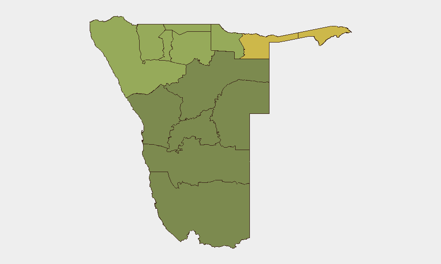
Namibia remains a low-threat environment with no verified security, conflict, civil-unrest, or infrastructure incidents in the past 24–48 hours. The national composite threat score is 3 (global rank: unranked), reflecting stable conditions nationwide. However, northern border regions—particularly Zambezi, Kavango East, and Kavango West—carry structurally elevated baseline risk due to cross-border activity, wildlife poaching, and resource competition, requiring sustained monitoring for corporate and NGO operations.
Key Developments
- No verified major incidents (24–48h window, nationwide). Cross-checked open-source reporting, major Namibian news outlets (Namibian, Informanté, NBC, Namibian Sun, Windhoek Express), and regional security feeds show no new security, conflict, civil-unrest, crime spikes, or travel-risk events meeting operational alert thresholds as of 31 July 2026.
- Routine crime monitoring gap. Smaller criminal incidents continue but typically lack precise publication timestamps; no acute clusters or organized crime escalations have been flagged in accessible channels over the last 48 hours.
- Northern border baseline risk remains elevated. Zambezi Region (risk score 68) and Kavango East/West (scores 62, 58) continue to show higher structural risk drivers, but no specific triggering events have been reported in the last 24–48 hours; risk posture reflects historical patterns and cross-border dynamics rather than acute incident.
- Digital ID campaign (July 2026, no security impact). Namibia is conducting a digital ID rollout campaign ahead of September implementation; no associated civil unrest or security incidents have been detected.
- Routine governance / enforcement activities. Minor criminal and legal proceedings continue (e.g., isolated assault and alleged misconduct cases) but do not indicate systemic unrest or threat escalation.
Highest-Risk Areas
Zambezi Region (risk 68) and the Kavango East–West corridor (combined risk 62–58) dominate sub-national threat rankings, driven by proximity to Angola and Botswana borders, poaching networks, and informal cross-border commerce. Kunene Region (52) and Oshikoto (48) follow, reflecting similar border-zone exposure. Central and southern regions (Hardap, Omaheke, Erongo) carry significantly lower baseline risk (25–32), making Windhoek and the south-central corridor more suitable for routine corporate and NGO operations. The risk gradient is pronounced: northern border zones require elevated vigilance and contingency planning; southern and central areas permit standard duty-of-care protocols.
How GeoBit Would Assist
Security teams operating in Namibia should employ AOI Monitoring & Early Warning on the high-risk northern regions to detect emerging cross-border activity, poaching operations, or resource-competition incidents before they escalate. OSINT Fusion & Corroboration (X/Twitter, Telegram, local news feeds, radio SIGINT) provides real-time signal integration and fact-checking for incidents that may lack official timestamps. Routing & Network Analysis supports safe travel planning in border zones by identifying alternative corridors and chokepoints; Satellite & Imagery Analysis can confirm poaching camps, trafficking hubs, or infrastructure disruptions. These capabilities together reduce operational blind spots and accelerate early warning in regions where formal reporting lags.
7-Day Outlook
No acute escalation triggers are visible; the stable, low-threat posture is expected to persist over the next 7 days barring unforeseen cross-border incidents or wildlife-poaching network activities in the north. Continued routine monitoring of northern regions and standard vigilance in central/southern areas remain appropriate. Heat and wildfire risk in winter months should be tracked in parallel via environmental feeds.
Highest-Risk Areas — Ranked
| # | State / Region | Risk |
|---|---|---|
| 1 | Zambezi | 68 |
| 2 | Kavango East | 62 |
| 3 | Kavango West | 58 |
| 4 | Kunene Region | 52 |
| 5 | Oshikoto | 48 |
| 6 | Ohangwena | 45 |
| 7 | Omusati | 42 |
| 8 | Oshana | 40 |
| 9 | Otjozondjupa | 35 |
| 10 | Erongo Region | 32 |
| 11 | Hardap | 28 |
| 12 | Omaheke | 25 |
Sources
Previous Daily Briefs
A new Namibia brief is written every day — each with its own risk map and downloadable CSV. Here's the last week; use the calendar to go further back.
📅 Browse every day by calendar →
Highlighted days have a brief. Tap a day for that day's map & analysis, or “csv” for that day's dataset ($5).
Atlas — our AI intelligence desk — emails them this snapshot personally. Nothing else, no list.