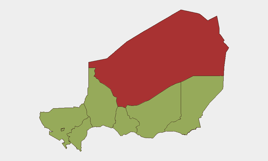
Situation Summary
Niger remains at moderate-to-high risk (global rank #27, composite threat score 69) amid an active U.S. military withdrawal and sustained jihadist pressure in northern and border regions. The country is experiencing a complex transition following recent political instability, with the CNSP junta consolidating control while Western military partners execute their exit. Agadez Region, hosting critical U.S. logistics hubs, presents the highest sub-national risk (78.2), while Niamey's political volatility and online mobilization around foreign-troop departure add secondary pressure to the capital and main corridors.
Key Developments
- Agadez Region (Air Base 201) – 14 June 2026: U.S. defense reporting and OSINT imagery confirm continued equipment drawdown, convoy movements, and base handover preparations as part of the mid-September withdrawal timeline. No direct threats to convoys have been reported, but perimeter restrictions remain elevated.
- Niamey (Capital) – 14 June 2026: Pro-junta and activist accounts on X/Twitter amplified online mobilization calls supporting the CNSP and opposing "foreign interference," linked to the accelerating U.S. and French departures. No confirmed large-scale street protests have been time-stamped to 13–14 June, but sentiment remains volatile.
- Niamey & Main Corridors – 13–14 June 2026: U.S. Pentagon statements and media coverage reiterate a "high-threat environment" for Western military personnel during withdrawal operations, citing active jihadist presence and potential anti-Western sentiment as ongoing hazards for base-linked movements.
- Niger–Mali & Niger–Burkina Borders (Liptako-Gourma) – 13–14 June 2026: Regional security commentary again identifies elevated jihadist activity (Islamic State Sahel, JNIM) in tri-border areas; rural road movements remain classified high-risk, though no new, specifically dated attacks inside Niger have been confirmed in the last 48 hours.
- National Travel Environment – 13–14 June 2026: International government advisories continue to classify all of Niger as "do not travel" or equivalent, citing terrorism, kidnapping, civil unrest, and political instability. Consular support remains limited for most Western nations.
Highest-Risk Areas
Agadez Region dominates the sub-national ranking (78.2) due to its concentration of foreign military assets, strategic mineral extraction activity, and proximity to ungoverned territories hosting jihadist cells. Niamey (50.7) follows as a secondary concern, driven by political volatility, anti-Western sentiment amplification, and presence of state security forces with inconsistent oversight. The remaining seven regions cluster at 48.2, reflecting diffuse but persistent jihadist and banditry threats across Zinder, Diffa, Tillabéri, Tahoua, Dosso, and Maradi—particularly acute in rural and border zones where governance is weakest.
How GeoBit Would Assist
Security teams should deploy AOI Monitoring & Early Warning on Agadez and Niamey to track military movements, protest mobilization, and checkpoint activity; pair this with OSINT fusion (X/Twitter, Telegram, multi-language feeds) to detect sentiment shifts and coordination calls in real time. Routing & Network Analysis can identify alternative travel corridors and safe passage windows as the U.S. withdrawal progresses, while Conflict & Military force-structure tracking provides early signals of jihadist repositioning in border areas.
7-Day Outlook
The U.S. withdrawal will likely accelerate logistics movements through Niamey and Agadez over the next week, maintaining heightened military traffic and security protocols. Online pro-junta mobilization is expected to continue, though organized street action remains uncertain. Jihadist groups in the north and tri-border zones will continue routine operations; any large-scale attack targeting foreign or Nigerien military assets would mark a tactical escalation.
Highest-Risk Areas — Ranked
| # | State / Region | Risk |
|---|---|---|
| 1 | Agadez Region | 78.2 |
| 2 | Niamey | 50.7 |
| 3 | Zinder Region | 48.2 |
| 4 | Diffa Region | 48.2 |
| 5 | Tillabéri Region | 48.2 |
| 6 | Tahoua Region | 48.2 |
| 7 | Dosso Region | 48.2 |
| 8 | Maradi Region | 48.2 |
Sources
Previous Daily Briefs
A new Niger brief is written every day — each with its own risk map and downloadable CSV. Here's the last week; use the calendar to go further back.
📅 Browse every day by calendar →
Highlighted days have a brief. Tap a day for that day's map & analysis, or “csv” for that day's dataset ($5).