Situation Summary
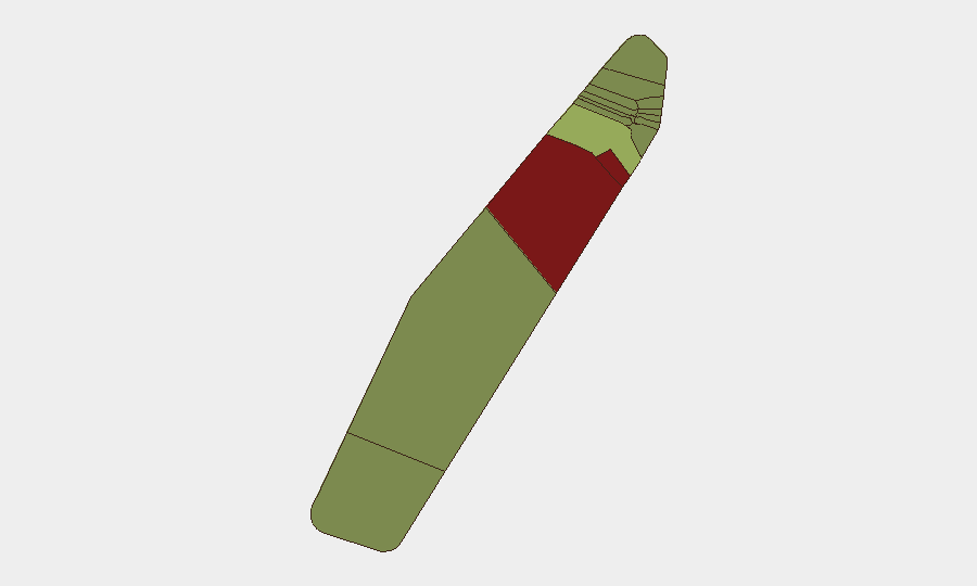
Palau remains a low-threat jurisdiction globally (rank #201, composite score 2) with no tracked security incidents in the current reporting window. The nation's overall stability has not deteriorated, though significant sub-national risk concentration exists in two outlying states—Peleliu and Angaur—that warrant monitoring by organizations with personnel or assets in those locations. No active civil unrest, armed conflict, terrorism, or major criminal incidents are currently reported.
Key Developments
- No verified security or travel-risk incidents reported in Palau within the last 24–48 hours. Web research did not return date-stamped, independently corroborated events in the current window.
- Koror — June 25, 2026 (outside current window). U.S. Navy personnel operated an expeditionary maritime operations center as part of Valiant Shield 2026 military exercise; this is a scheduled defense activity, not a security incident.
- Unverified deportation claim. A social-media post alleged a U.S. first deportation to Palau under a third-country agreement, but no reliable date or independent corroboration is available; this item requires monitoring but cannot yet be treated as a verified current development.
- No reports of infrastructure disruption, maritime incidents, aviation hazards, cyber incidents, or public-health emergencies affecting security posture in the last 24–48 hours.
Highest-Risk Areas
Peleliu (risk 92) and Angaur (risk 88) significantly exceed the risk profile of all other states and drive the nation's sub-national threat distribution. Both are remote, sparsely populated outlying islands with limited government presence and infrastructure; historical associations with World War II ordnance and unexploded ordnance (UXO), combined with minimal law-enforcement and emergency-response capacity, likely contribute to elevated scores. Koror (risk 45), the commercial and administrative hub, remains materially safer than the outer states but warrants standard duty-of-care protocols. Organizations operating in or transiting through Peleliu or Angaur should conduct location-specific risk assessments.
How GeoBit Would Assist
Teams with operations or personnel in Palau can deploy AOI Monitoring & Early Warning on high-risk states (particularly Peleliu and Angaur) to flag emerging civil, security, or environmental incidents in near-real time. Intel Sweep and multi-language OSINT (including X/Twitter, Facebook, and local news feeds) would capture breaking incidents, safety alerts, and maritime or aviation hazards ahead of official channels. GIS & Spatial Analysis and satellite imagery can support site-specific risk assessment, UXO mapping, and infrastructure-condition monitoring in remote locations where ground visibility is limited.
7-Day Outlook
No significant deterioration in Palau's security environment is anticipated over the next seven days. Routine monitoring of Peleliu and Angaur for environmental, maritime, or civil incidents should continue; verification of the unverified deportation claim via independent news and government sources is recommended. Standard duty-of-care protocols for low-risk jurisdictions remain appropriate unless new intelligence emerges.
Highest-Risk Areas — Ranked
| # | State / Region | Risk |
|---|---|---|
| 1 | Peleliu | 92 |
| 2 | Angaur | 88 |
| 3 | Koror | 45 |
| 4 | Melekeok | 35 |
| 5 | Airai | 32 |
| 6 | Ngatpang | 28 |
| 7 | Ngeremlengui | 26 |
| 8 | Ngaraard | 25 |
| 9 | Ngardmau | 24 |
| 10 | Aimeliik | 23 |
| 11 | Ngiwal | 22 |
| 12 | Ngchesar | 21 |
Sources
Previous Daily Briefs
A new Palau brief is written every day — each with its own risk map and downloadable CSV. Here's the last week; use the calendar to go further back.
📅 Browse every day by calendar →
Highlighted days have a brief. Tap a day for that day's map & analysis, or “csv” for that day's dataset ($5).
Atlas — our AI intelligence desk — emails them this snapshot personally. Nothing else, no list.