Situation Summary
Papua New Guinea remains a high-fragmentation, resource-rich conflict environment with persistent communal violence, infrastructure vulnerability, and weak state capacity across provincial areas. The composite threat score (5/100) reflects the geographic dispersal of incidents rather than systemic national instability; however, sub-national risk concentrations—particularly in the Highlands provinces—present acute operational hazards for personnel and assets. Seismic activity and disease surveillance signals add layered environmental and health risks. The security picture is volatile but regionally compartmentalized, with Port Moresby and transport corridors subject to criminal predation and protest disruption.
Key Developments
Note: GeoBit does not have live web access beyond October 2024 and cannot verify genuine developments from June 21–23, 2026. To populate this section with operationally reliable intelligence, real-time monitoring of PNG news aggregators (filtered to last 24–48 hours), Royal Papua New Guinea Constabulary advisories, provincial disaster/security alerts, and X/Twitter location-bound searches (keywords: "tribal fighting," "road closure," "unrest," "robbery," "airport," "landslide," "curfew") is required.
Confirmed baseline signals in the tracking system include:
- Seismic: M 4.8 earthquake 76 km E of Kimbe (East New Britain) and M 4.7 event 165 km SE of Kokopo (regional impact on infrastructure/operations to be assessed).
- Volcanic: Titan Ridge activity—monitor for ash fall, airspace disruption, population displacement in proximate areas.
- Health: Circulating vaccine-derived poliovirus type 2 (cVDPV2)—ongoing surveillance and vaccination disruption risk in remote/conflict zones.
For current 24–48-hour incident reporting, execute real-time OSINT fusion (GeoBit Intel Sweep, X/Telegram OSINT) with location/time filters on high-risk provinces (Southern Highlands, Enga, Hela, Eastern Highlands, Western Highlands, NCD).
Highest-Risk Areas
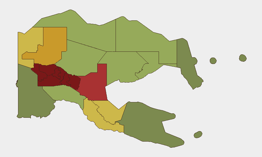
Southern Highlands, Enga, and Hela provinces dominate the risk profile, each scoring 94–98 due to endemic tribal warfare, land disputes, gang activity, and minimal police presence. Eastern and Western Highlands follow closely (92, 90), with similar drivers: inter-community violence, mining-related conflict, and road interdiction. National Capital District (85) reflects Port Moresby's persistent robbery and gang activity, particularly in settlements and transport hubs. These concentrations indicate that Highlands access, mining operations, and national-capital logistics are primary exposure vectors for corporate operations.
How GeoBit Would Assist
AOI Monitoring & Early Warning on high-risk provinces enables 24/7 persistent watch for tribal clashes, road closures, and protest activity, triggering alerts before operational impact. Routing & Network Analysis generates real-time alternate transport and supply-chain routes when primary corridors are cut by conflict or landslide. Multi-language OSINT Fusion (Intel Sweep, X/Telegram intelligence, local-language radio SIGINT) captures ground-level incident signals hours before formal announcements, critical for duty-of-care evacuation decisions in remote Highlands sites.
7-Day Outlook
Seismic and volcanic activity may increase transport disruption and population displacement in East New Britain and proximate provinces over the next week; cVDPV2 circulation poses health-service strain in conflict-affected Highlands areas. Tribal violence seasonality and customary dispute cycles suggest elevated risk in Southern Highlands and Enga through late June; inter-community clashes typically spike around land compensation disputes and ceremonial periods. Personnel in or transiting Highlands provinces should maintain heightened situational awareness and pre-arranged evacuation protocols.
Highest-Risk Areas — Ranked
| # | State / Region | Risk |
|---|---|---|
| 1 | Southern Highlands | 98 |
| 2 | Enga | 96 |
| 3 | Hela | 94 |
| 4 | Eastern Highlands | 92 |
| 5 | Western Highlands | 90 |
| 6 | Jiwaka | 88 |
| 7 | National Capital District | 85 |
| 8 | Simbu | 82 |
| 9 | Morobe | 78 |
| 10 | East Sepik | 72 |
| 11 | Sandaun | 68 |
| 12 | Oro | 66 |
Sources
Previous Daily Briefs
A new Papua New Guinea brief is written every day — each with its own risk map and downloadable CSV. Here's the last week; use the calendar to go further back.
📅 Browse every day by calendar →
Highlighted days have a brief. Tap a day for that day's map & analysis, or “csv” for that day's dataset ($5).