Situation Summary
Qatar's security environment has deteriorated sharply over the past 48 hours following a resumed US–Iran military escalation. On 23 July 2026 (early hours), Iranian missile and drone strikes targeted US military facilities in Qatar, prompting active air-defense engagements and mobile shelter-in-place alerts across Doha. While Qatar's Ministry of Defense confirmed successful interception of the attack with no reported mass casualties, the incident marks a significant shift from the prior regional posture and has triggered elevated travel warnings from multiple foreign governments, including France.
Key Developments
- Doha airspace and capital area (23 July, 0300–0600 local): Multiple explosions reported across Doha consistent with air-defense interceptions of Iranian missile/drone strikes; residents received mobile emergency alerts instructing immediate shelter; Ministry of Interior subsequently declared the immediate threat eliminated and situation restored to normal.
- US military facilities in Qatar, likely Al Udeid air base vicinity (22–23 July): Iranian forces conducted coordinated strikes against US installations as part of a wider barrage also targeting Kuwait, Bahrain, Jordan, and Oman; air-defense engagements reported with localized blast and debris hazards but no confirmed structural damage to facilities.
- Qatari airspace operational status (23 July): Despite reopening to overflights, EASA now advises operators to avoid Qatari airspace at all levels due to increased GPS jamming/spoofing risk and residual air-defense activity; civil aviation operators face elevated hazard zones in interception corridors.
- Foreign government travel advisories (23 July): French foreign ministry updated its Qatar alert to warn nationals of Iranian strikes "again" targeting Qatari territory, instructing vigilance, shelter-in-place compliance during alerts, avoidance of military installations, and non-approach of interception debris.
- Qatari political messaging (22–23 July): Qatar's leadership publicly rejected Israeli media claims of participation in military action against Iran, reasserting its mediator role; messaging occurs amid direct Iranian attack on Qatari territory, signaling heightened diplomatic sensitivity and potential information-warfare activity.
- Air-defense posture (ongoing): Qatari armed forces maintained elevated operational status with visible air-defense systems and repeated siren activations; Ministry of Defense communications confirm active threat monitoring and interception capability.
Highest-Risk Areas
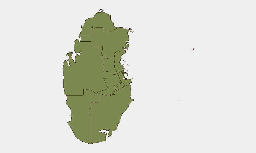
Doha dominates the sub-national risk profile (31.4 vs. 1.4 for all other municipalities), reflecting its concentration of US military facilities, critical infrastructure, and civilian population centers. The capital's airspace and immediate surroundings face the highest interception hazard and blast debris risk from air-defense engagements. Peripheral emirates (Ash Shamal, Al Rayyan, Al Khor) carry baseline elevation due to proximity to military installations and overflight corridors, but represent secondary risk relative to the capital's direct exposure to inbound and intercepted ordnance.
How GeoBit Would Assist
Security teams would use AOI Monitoring & Early Warning to maintain persistent watch on Doha airspace, US facility perimeters, and air-defense activity with real-time alerting of new missile/drone launches or interception events. Aviation tracking, OSINT fusion, and conflict mapping capabilities enable rapid assessment of flight corridor safety, debris hazard zones, and force-positioning changes. Intel Sweep and multi-language OSINT across X, Telegram, Al Jazeera, and regional media provide continuous situational updates on Iranian strike intentions, Qatari interception success rates, and escalation/de-escalation signals before they appear in formal government advisories.
7-Day Outlook
The near-term trajectory hinges on whether Iran conducts follow-on strikes or whether the interception success and Qatari diplomatic posturing signal a localized engagement rather than sustained barrage. Airspace and facility-access restrictions are likely to remain in effect for 5–10 days pending no new activity; however, elevated air-defense readiness and GPS jamming will persist. Regional de-escalation rhetoric should be monitored closely, as any Iranian claims of "mission accomplished" or US counterstrikes would trigger a second surge in Doha-area threat levels.
Highest-Risk Areas — Ranked
| # | State / Region | Risk |
|---|---|---|
| 1 | Doha | 31.4 |
| 2 | Ash Shamal | 1.4 |
| 3 | Al Shahaniya | 1.4 |
| 4 | Al Rayyan | 1.4 |
| 5 | Al Khor and Al Thakhira | 1.4 |
| 6 | Al-Daayen | 1.4 |
| 7 | Umm Salal | 1.4 |
| 8 | Al Wakrah | 1.4 |
Sources
Previous Daily Briefs
A new Qatar brief is written every day — each with its own risk map and downloadable CSV. Here's the last week; use the calendar to go further back.
📅 Browse every day by calendar →
Highlighted days have a brief. Tap a day for that day's map & analysis, or “csv” for that day's dataset ($5).
Atlas — our AI intelligence desk — emails them this snapshot personally. Nothing else, no list.