ملخص الوضع
تشهد قطر تصعيداً أمنياً حاداً ناجماً عن غارات إيرانية متجددة بالصواريخ والطائرات بدون طيار على المجال الجوي للدولة كجزء من قصف إقليمي أوسع يؤثر على عدة دول خليجية (الأردن، البحرين، الكويت) في 21-22 يوليو 2026. نجحت أنظمة الدفاع الجوي القطرية في اعتراض عدة تهديدات واردة، مما منع خسائر جماعية، لكن الانفجارات الناجمة عن الاعتراضات والحطام تسببت في إصابات محلية وحفزت تنبيهات حكومية بالبقاء في المأوى ورفع مستوى التأهب. تبقى التوترات الدبلوماسية مع القوى الإقليمية (الإمارات العربية المتحدة والمملكة العربية السعودية) نشطة؛ وتضيف إشارات التعبئة العسكرية المتزامنة وتقارير عن تورط قوات عسكرية تقليدية باكستانية وإسرائيلية تعقيداً إضافياً على بيئة التهديد. تبقى درجة التهديد الوطني المركبة معتدلة (21)، لكن تركز المخاطر في الدوحة (31.3) يعكس دور العاصمة كمركز دبلوماسي وعسكري وطيران معرض الآن مباشرة للعمليات العدائية الإقليمية.
التطورات الرئيسية
- الدوحة (مناطق متعددة)، 21 يوليو 2026 22:00–23:30 بتوقيت UTC: أبلغ السكان عن انفجارات متعددة وأصوات دوي خلال الليل مع قيام أنظمة الدفاع الجوي القطرية بالتصدي للقذائف الإيرانية الواردة؛ أصدرت الحكومة تنبيهات جوال بالبقاء في المأوى ورفعت مستوى التهديد إلى "مرتفع".
- الدوحة (خليج الغرب والمناطق الوسطى)، 21 يوليو 2026 23:45–22 يوليو 01:15 بتوقيت UTC: دوت صفارات الإنذار خلال غارة إيرانية ثانية؛ وجهت تنبيهات السلامة عبر الجوال السكان مرة أخرى للاحتماء؛ كانت أصوات اعتراضات الدفاع الجوي مسموعة في جميع أنحاء العاصمة.
- الدوحة (محيط السفارة الأمريكية والمرافق العسكرية)، 21 يوليو 2026: أشارت تقارير وسائط الإعلام والشبكات الاجتماعية إلى إجلاء السكان القريبين وسط مخاوف من استهداف الصواريخ الإيرانية لمواقع مرتبطة بالولايات المتحدة؛ تم الإبلاغ عن نشاط الاعتراضات بدلاً من الضربات المباشرة.
- قطر (المجال الجوي الوطني)، 21-22 يوليو 2026: أكدت القوات المسلحة القطرية اعتراض عدة تهديدات جوية؛ لم يتم الإفصاح عن إجمالي رسمي للخسائر أو الأضرار، لكن رسائل الأمم المتحدة المرفوعة من قطر توثق إصابات بما فيها للأطفال من غارات إيرانية سابقة والحطام.
- قطر (الطيران المدني)، 21-22 يوليو 2026: حافظت وكالة سلامة الطيران الأوروبية على إرشادات تجنب المجال الجوي حتى 29 يوليو 2026؛ حذرت عدة حكومات من احتمال حدوث اضطرابات في الرحلات عبر الدوحة بسبب نشاط القصف الإيراني المستمر.
- قطر (تحذيرات السفر للخارج)، 21-22 يوليو 2026: حثت تحذيرات محدثة من الحكومات الحليفة على اليقظة المتزايدة والالتزام بتنبيهات المأوى وتجنب المرافق العسكرية والاستعداد للتغييرات السريعة في الأمن وحالة الرحلات.
- قطر (الدبلوماسية)، 21 يوليو 2026: أصدرت وزارة الخارجية بياناً يدين الهجمات الإيرانية المتجددة على الدول المجاورة؛ تم الإبلاغ عن تعبئة عسكرية متزامنة وإشارات قوات عسكرية تقليدية تتضمن باكستان وإسرائيل.
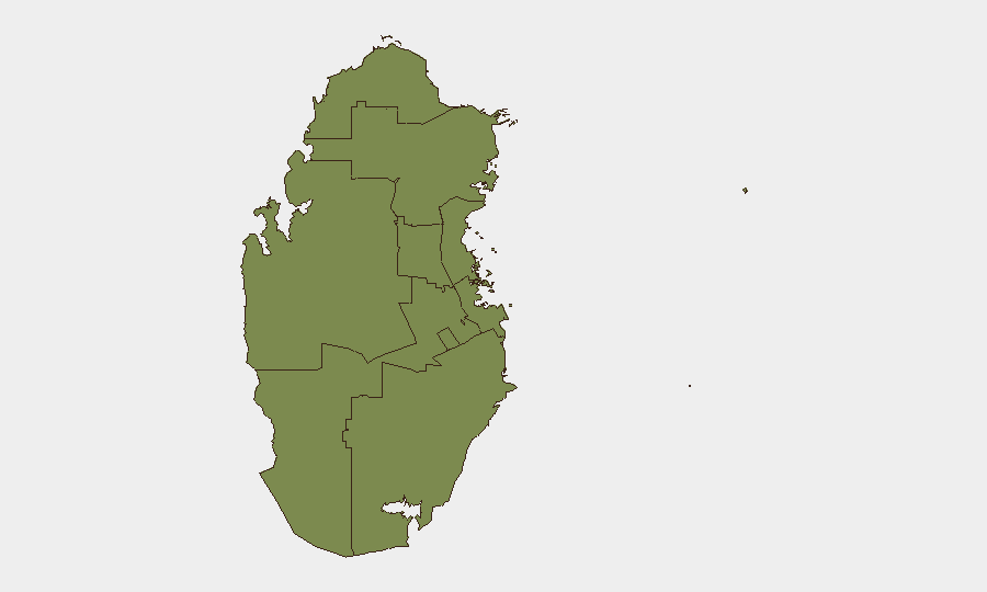
المناطق الأكثر عرضة للخطر
تمثل الدوحة الغالبية العظمى من المخاطر المتتبعة (31.3 من درجة التهديد المركبة الوطنية البالغة 21)، مما يعكس تركزها للبعثات الدبلوماسية والبنية التحتية العسكرية والمرافق الأمريكية والسكان المدنيين. يستمر التعرض المباشر للعاصمة للضربات الصاروخية والطائرات بدون طيار الإيرانية في 21-22 يوليو 2026، جنباً إلى جنب مع التوترات الإقليمية المستمرة والإشارات العسكرية، في الحفاظ على وضع التأهب المرتفع. تحمل جميع المناطق دون الوطنية الأخرى (الشحانية، الشمال، الريان، وغيرها) درجات فردية قليلة (1.3–6.3)، مما يشير إلى أن المخاطر تركزت جغرافياً في العاصمة بدلا
المناطق الأعلى خطورة — مرتبة
| # | الولاية / المنطقة | الخطر |
|---|---|---|
| 1 | Doha | 31.3 |
| 2 | Al Shahaniya | 6.3 |
| 3 | Ash Shamal | 1.3 |
| 4 | Al Rayyan | 1.3 |
| 5 | Al Khor and Al Thakhira | 1.3 |
| 6 | Al-Daayen | 1.3 |
| 7 | Umm Salal | 1.3 |
| 8 | Al Wakrah | 1.3 |
المصادر
الموجزات اليومية السابقة
يُنشر موجز جديد عن Qatar كل يوم — لكل منها خريطة مخاطر وملف CSV قابل للتنزيل. هذا هو الأسبوع الأخير؛ استخدم التقويم للرجوع أبعد.
📅 Browse every day by calendar →
Highlighted days have a brief. Tap a day for that day's map & analysis, or “csv” for that day's dataset ($5).
Atlas — our AI intelligence desk — emails them this snapshot personally. Nothing else, no list.