Situation Summary
Samoa remains a low-threat environment with no credible reports of civil unrest, violent crime, or political instability in the past 24–48 hours. The composite threat score of 8 (ranking #123 globally) reflects baseline exposures to natural hazards and routine governance activity rather than acute security crises. Current open-source reporting confirms normal operational conditions across the archipelago, with no travel, infrastructure, or safety advisories in effect.
Key Developments
- Nationwide, Samoa – 01 Jul 2026: Samoa Meteorology Division issued an earthquake information bulletin for a magnitude 6.0 event in the Mexico region, explicitly confirming no tsunami threat to Samoa and no evacuation orders. Confirms no active natural-hazard impact on travel or operations.
- U.S. Government Security Engagement – 01–04 Jul 2026: U.S. Department of State scheduled senior official-led "Security Updates for U.S. Citizens" activities covering Samoa and other countries. Routine diplomatic/consular engagement with no associated incident or travel warning.
- Recent Court–Parliament Interaction – 29 Jun 2026: Supreme Court issued rejection and disapproval statements relating to parliamentary matters (specific details limited in open sources). No reports of wider political disruption or institutional breakdown.
- Government Statement – 29 Jun 2026: Samoa government issued a public statement on 29 June; content not detailed in available reporting. Appears routine; no emergency declaration, security alert, or curfew order noted.
- No Civil Unrest or Crime Spike – Last 48 Hours: Local news and social-media monitoring show no reports of protests, riots, gang violence, or major criminal incidents in Apia, Upolu, or Savai'i.
- Infrastructure Status – Current: No alerts regarding port, airport, power, or telecommunications disruptions affecting normal business or travel operations.
Highest-Risk Areas
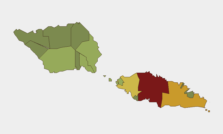
Tuamasaga (risk score 85) and Ātua (risk score 71) drive Samoa's sub-national risk profile, likely reflecting population concentration, urban crime exposure, and port/commercial activity in the Apia region. Aʻana (62) and Aiga-i-le-Tai (55) follow, while outer districts (Vaisigano, Vaʻa-o-Fonoti) score substantially lower. Risk in the capital district reflects typical urban hazards—petty crime, traffic, transient labor issues—rather than organized violence or sectarian conflict. Outer regions present lower urban-crime footprints but remain vulnerable to cyclone and tsunami exposure common to the South Pacific.
How GeoBit Would Assist
Intelligence & OSINT capabilities (Intel Sweep, multi-language search, sentiment analysis, X/Twitter and local social-media monitoring) enable near-real-time detection of emerging unrest, crime spikes, or political tensions before they affect operations. AOI Monitoring & Early Warning with persistent watch on Apia, Upolu ports, and government/court venues would provide automated alerting if incident patterns shift. Risk & Threat Assessment and Routing & Network Analysis support contingency planning for personnel movement and supply-chain resilience if conditions deteriorate.
7-Day Outlook
Samoa's security posture is expected to remain stable over the next seven days absent new geopolitical shocks or natural-hazard escalation. Routine court–parliament interactions and government statements show normal institutional function. Cyclone season (Nov–April in the South Pacific) is not currently a concern; the near-term threat environment is minor and localized to petty crime and routine governance friction.
Highest-Risk Areas — Ranked
| # | State / Region | Risk |
|---|---|---|
| 1 | Tuamasaga | 85 |
| 2 | Ātua | 71 |
| 3 | Aʻana | 62 |
| 4 | Aiga-i-le-Tai | 55 |
| 5 | Faʻasaleleaga | 48 |
| 6 | Palauli | 42 |
| 7 | Satupaʻitea | 38 |
| 8 | Gagaʻemauga | 35 |
| 9 | Gagaʻifomauga | 32 |
| 10 | Vaisigano | 28 |
| 11 | Vaʻa-o-Fonoti | 23 |
Sources
Previous Daily Briefs
A new Samoa brief is written every day — each with its own risk map and downloadable CSV. Here's the last week; use the calendar to go further back.
📅 Browse every day by calendar →
Highlighted days have a brief. Tap a day for that day's map & analysis, or “csv” for that day's dataset ($5).