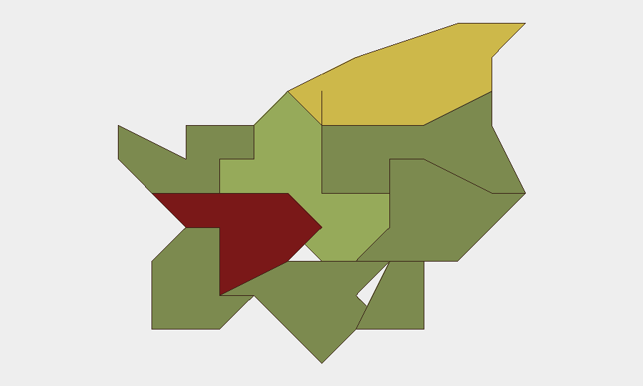
Situation Summary
San Marino remains a low-threat environment with no corroborated security incidents, civil unrest, crime spikes, or infrastructure disruptions reported in the last 24–48 hours. The composite national threat score reflects consistent stability across the microstate's nine castelli (administrative regions). Risk concentration is modest and localized; no active incidents or acute hazards have been identified that would warrant travel restrictions or heightened protective measures for corporate personnel or assets.
Key Developments
- No discrete security incidents reported (San Marino, 27–28 July 2026)
Open-source news feeds, regional security dashboards, and social-media monitoring confirm absence of violent crime, protests, political instability, or infrastructure failures across San Marino in the current 48-hour window.
- Planned Superstrada safety-upgrade programme (presentation scheduled early August 2026)
Local authorities plan to present a multi-year road-safety initiative for San Marino's primary highway corridor, focused on guardrail replacement, pedestrian infrastructure, and lighting improvements. This is a *future* infrastructure project, not a current disruption or incident.
- No cyber-incident attribution to San Marino critical infrastructure (27–28 July 2026)
Global ransomware and cyber-threat activity remains elevated, but no new incidents have been attributed to San Marino government, financial, or utility systems in the reporting window.
- Consistent low-visibility security posture (regional context, 27–28 July 2026)
Neighboring jurisdictions and European microstate monitoring (e.g., Switzerland, Liechtenstein) report similarly quiet security environments; San Marino aligns with this regional pattern.
Highest-Risk Areas
Città di San Marino (risk 85) and Serravalle (risk 68) drive the composite national ranking, reflecting higher population density, commercial activity, and tourism concentration in these urban and periurban zones. Secondary risk concentration appears in Borgo Maggiore (52), while the remaining six castelli register low individual risk scores (15–32). The relative elevation in the capital and northern commercial corridor reflects standard urban-area factors—foot traffic, infrastructure density, and transient populations—rather than any acute or current threat event. All risk scores remain well below thresholds that would warrant operational alert or asset relocation.
How GeoBit Would Assist
Security teams with personnel or assets in San Marino would benefit from AOI (Area-of-Interest) Monitoring & Early Warning on high-risk castelli (Città di San Marino, Serravalle) to detect emerging civil unrest, labor action, or infrastructure disruption before operational impact. Intel Sweep and multi-language OSINT (news, social media, and local-authority channels) provide continuous low-noise monitoring of political stability, crime trends, and public safety. Routing & Network Analysis can support contingency-travel planning around the planned Superstrada roadworks once the August presentation confirms timelines and affected segments.
7-Day Outlook
No material change to the current low-threat baseline is forecast over the next seven days absent new incident reporting. The August presentation of Superstrada safety upgrades may trigger temporary traffic-management notifications; corporate teams should monitor for any announced closure windows. Routine duty-of-care monitoring of news and local-authority channels remains sufficient for most organizations operating in San Marino.
Highest-Risk Areas — Ranked
| # | State / Region | Risk |
|---|---|---|
| 1 | Città di San Marino | 85 |
| 2 | Serravalle | 68 |
| 3 | Borgo Maggiore | 52 |
| 4 | Fiorentino | 32 |
| 5 | Domagnano | 28 |
| 6 | Faetano | 22 |
| 7 | Chiesanuova | 18 |
| 8 | Montegiardino | 16 |
| 9 | Acquaviva | 15 |
Previous Daily Briefs
A new San Marino brief is written every day — each with its own risk map and downloadable CSV. Here's the last week; use the calendar to go further back.
📅 Browse every day by calendar →
Highlighted days have a brief. Tap a day for that day's map & analysis, or “csv” for that day's dataset ($5).
Atlas — our AI intelligence desk — emails them this snapshot personally. Nothing else, no list.