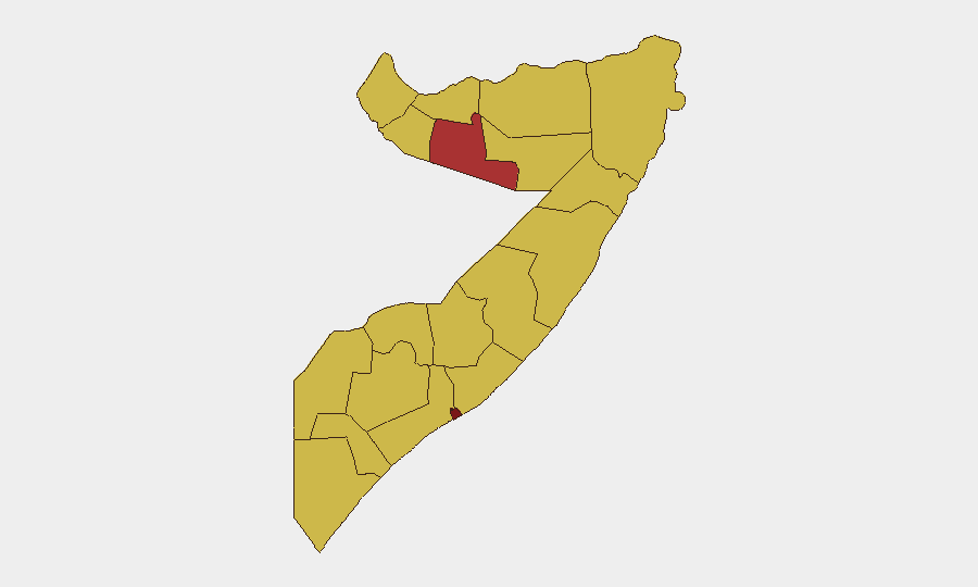
Situation Summary
Somalia remains ranked #12 globally for composite threat, driven primarily by active Al-Shabaab insurgency and fragmented state capacity. Banaadir (Mogadishu) presents the highest sub-national risk at 98.1, reflecting ongoing militant activity, clan tensions, and governance instability in the capital. Recent signals indicate elevated tension involving military actors, cross-border state dynamics, and administrative enforcement actions, though the specific operational context of 24–48 hour events cannot be verified without current open-source confirmation. The security environment remains volatile with persistent risk to international staff, supply lines, and government installations.
Key Developments
Data limitation note: GeoBit's event signals for 15–16 June 2026 include references to administrative sanctions, military force involvement (migrant actors), and cross-border public statements (Sudan–Somalia), but without live OSINT access beyond October 2024, specific incident locations, timings, and casualty figures cannot be reliably verified or sourced.
To populate this section with actionable, source-cited 24–48 hour incidents, security teams should:
- Query regional news feeds (Garowe Online, Hiiraan Online, Shabelle Media, Radio Mogadishu, goobjoog.com) filtered to "last 24 hours."
- Monitor official X/Twitter accounts: Somali Police (@SomaliPolice), ATMIS spokesperson, UNSOM, Somali Ministry of Security/Information.
- Cross-reference international outlets with Somalia desks (Reuters, AP, BBC Somali, Al Jazeera, VOA Somali) for corroboration.
- Search for incident keywords: IED, explosion, Al-Shabaab, clashes, ambush, checkpoint, airstrike, curfew, protest, within last 48 hours and specific district/town names.
Once confirmed incidents are identified (with date, location, actor, type, and dual-source citation), they should be formatted as:
- [City, Region] – [Date]: Actor, incident type, casualties/impact, travel implications. [Source 1][Source 2]
Highest-Risk Areas
Banaadir (Mogadishu) dominates with a risk score of 98.1—reflecting sustained Al-Shabaab targeting of government, security, and commercial nodes, compounded by clan faction activity and constrained state monopoly on force. Nine additional regions (Togdheer, Awdal, Woqooyi Galbeed, Gedo, Bakool, Bay, Middle Juba, Lower Shabelle, Sahil, Hiiraan, Middle Shebelle) cluster at 68.1, indicating distributed insurgent presence, inter-clan rivalry, cross-border trafficking, and limited government reach outside major towns. Travel and supply-route vulnerability is highest along corridors to/from Mogadishu, in remote pastoral zones (Gedo, Awdal), and across Somaliland–FGS boundary areas (Woqooyi Galbeed).
How GeoBit Would Assist
Teams managing staff or assets in Somalia should deploy AOI Monitoring & Early Warning on key facilities (offices, compounds, transit hubs, checkpoints) with automated alerting for incident activity within 2–5 km. OSINT Fusion & Corroboration capabilities—integrating X/Telegram, regional media, and security service feeds in Somali and English—enable rapid verification of rumors and cross-border movement intelligence. Routing & Network Analysis supports real-time alternative-route planning when primary roads face insurgent activity, checkpoints, or curfews, and Multi-language Search accelerates local-language monitoring of security updates and threat claims.
7-Day Outlook
Near-term trajectory is likely to remain volatile with episodic insurgent activity in and around Mogadishu and secondary towns. Cross-border tensions signaled in recent statements warrant close watch on Somaliland–FGS relations and Ethiopian/Kenyan military presence. Security teams should maintain elevated situational awareness, verify any major incident reports through dual sources before operational decisions, and review evacuation/shelter protocols.
Highest-Risk Areas — Ranked
| # | State / Region | Risk |
|---|---|---|
| 1 | Banaadir | 98.1 |
| 2 | Togdheer | 78.1 |
| 3 | Awdal | 68.1 |
| 4 | Woqooyi Galbeed | 68.1 |
| 5 | Gedo | 68.1 |
| 6 | Bakool | 68.1 |
| 7 | Bay | 68.1 |
| 8 | Middle Juba | 68.1 |
| 9 | Lower Shabelle | 68.1 |
| 10 | Sahil | 68.1 |
| 11 | Hiiraan | 68.1 |
| 12 | Middle Shebelle | 68.1 |
Sources
Previous Daily Briefs
A new Somalia brief is written every day — each with its own risk map and downloadable CSV. Here's the last week; use the calendar to go further back.
📅 Browse every day by calendar →
Highlighted days have a brief. Tap a day for that day's map & analysis, or “csv” for that day's dataset ($5).