Situation Summary
Sudan remains in active civil war between the Sudanese Armed Forces (SAF) and Rapid Support Forces (RSF), with the UN characterizing the current ceasefire as a "lesser-fire" marked by escalating attacks and rhetoric across multiple fronts as of 10–11 June. Khartoum and surrounding areas continue to experience shelling, destruction, and intermittent fighting, while border regions see intensified military operations. The political situation is simultaneously fragmented, with key factions rejecting or failing to endorse a recently negotiated roadmap for settlement, indicating that short-term de-escalation remains unlikely.
Key Developments
- Kurmuk, Blue Nile State (10–11 June): SAF launched an intensified drone campaign targeting RSF positions in the Ethiopia–Sudan border town, aimed at reclaiming the town and severing RSF supply lines. Multiple strikes were reported over the 24–48 hour period.
- Khartoum – Multiple Neighborhoods (11 June): IRC field update (posted ~9 hours prior to brief capture) documented ongoing insecurity, shelling, and destruction. Communities remain under intermittent attack with severely constrained humanitarian access, confirming volatile conditions in the capital in the last 24 hours.
- Nationwide Political Fragmentation (10–11 June reporting): Key Sudanese political groups rejected or failed to endorse a ceasefire/political roadmap agreed in Addis Ababa (3–5 June), indicating continued political deadlock and stalled peace efforts as of the current reporting window.
- UN Assessment – Country-Wide Deterioration (10 June briefing): Senior UN official characterized the ceasefire as deteriorating, citing escalating attacks and hostile rhetoric across multiple fronts in the 48 hours preceding the briefing.
- Arrest/Detention Activity (11–12 June): Multiple detention events involving Sudanese authorities and detectives were recorded, consistent with ongoing instability and potential extrajudicial actions.
Highest-Risk Areas
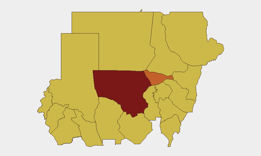
North Kordofan State (risk 100) remains the single highest-risk zone, followed by Khartoum (73.1), Kassala, and North Darfur (70+). The clustering of extreme risk in Khartoum reflects ongoing urban warfare, shelling, and humanitarian collapse in the capital. Border and eastern states—Kassala, North Darfur, Blue Nile, and Red Sea—are elevated primarily due to active SAF–RSF ground and air operations, supply-line disruption, and cross-border refugee movements. The concentration of risk in the north and east reflects the war's geographic center of gravity and the failure of ceasefire mechanisms to establish stability.
How GeoBit Would Assist
Security and duty-of-care teams with personnel or assets in Sudan should employ AOI Monitoring & Early Warning to track Khartoum, Blue Nile, and North Darfur with persistent alerting on military movements, shelling, and detention activity. Battle Mapping and Force Structure tracking would provide near-real-time clarity on SAF and RSF positions, enabling safer routing and asset relocation decisions. OSINT Fusion & Corroboration (combining X/Telegram monitoring, regional media, and UN briefing analysis) will surface political developments and ceasefire breakdowns faster than open news cycles, supporting executive decision-making on withdrawal or staff reduction.
7-Day Outlook
The rejection of the Addis Ababa roadmap and continued military escalation in Blue Nile and surrounding regions suggest that fighting will intensify over the next 7 days, with higher risk of SAF–RSF clashes along supply corridors. Khartoum will likely remain under intermittent shelling and subject to potential secondary security incidents (arrests, looting, or factional violence). Organizations should anticipate further deterioration in humanitarian access and hardened security postures for all field operations.
Highest-Risk Areas — Ranked
| # | State / Region | Risk |
|---|---|---|
| 1 | North Kordofan State | 100 |
| 2 | Al Khartum | 73.1 |
| 3 | Kassala State | 70.4 |
| 4 | North Darfur State | 70.2 |
| 5 | Blue Nile | 70 |
| 6 | River Nile State | 70 |
| 7 | Aj Jazira | 70 |
| 8 | Red Sea State | 70 |
| 9 | Al Qadarif State | 70 |
| 10 | Sennar State | 70 |
| 11 | Central Darfur State | 70 |
| 12 | South Darfur State | 70 |
Sources
Previous Daily Briefs
A new Sudan brief is written every day — each with its own risk map and downloadable CSV. Here's the last week; use the calendar to go further back.
📅 Browse every day by calendar →
Highlighted days have a brief. Tap a day for that day's map & analysis, or “csv” for that day's dataset ($5).