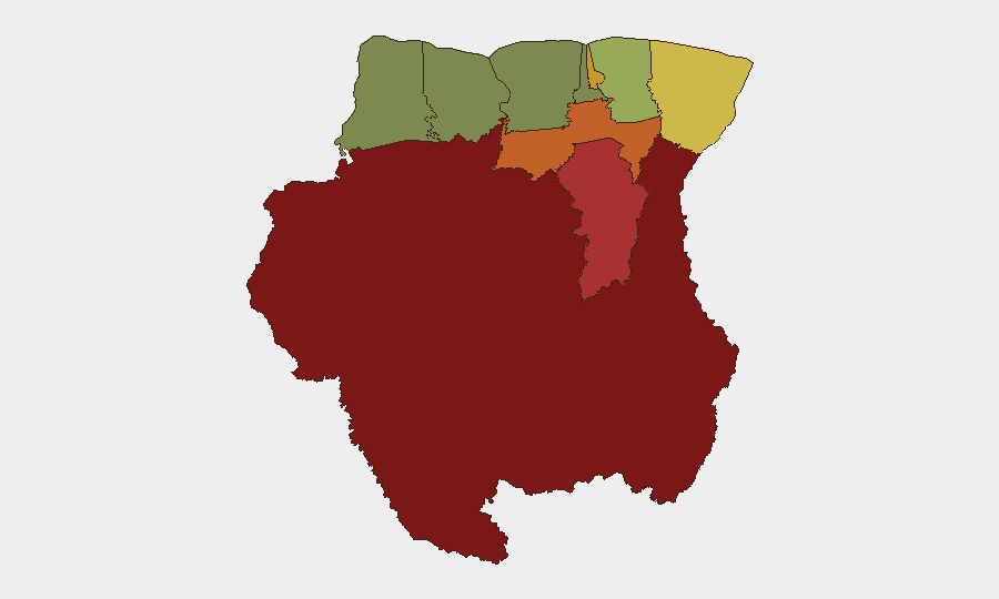
Situation Summary
Suriname remains a low-to-moderate threat environment (global rank #83, composite score 14) with concentrated risk in remote interior regions rather than urban centers. No verified, multi-source security incidents have been reported in the last 24–48 hours; the current threat picture is defined by persistent geographic disparities—interior districts face substantially higher risk of criminal activity and armed group presence, while coastal urban areas remain relatively stable. Recent macro-level developments (concessional financing access, regional weather monitoring) indicate ongoing efforts to address structural vulnerabilities, though no acute destabilization is evident.
Key Developments
- No verified, location-specific security incidents reported in Suriname in the last 24–48 hours. Open-source monitoring (news outlets, institutional alerts, embassy advisories, local social media) has not surfaced credible reports of civil unrest, armed clashes, infrastructure failures, or targeted travel warnings dated 2026-06-30 to 2026-07-02.
- Regional weather alert remains active (2026-07-01). U.S. Embassy Caracas issued ongoing monitoring for severe weather impacts across northern South America; no new incidents in Suriname reported, but persistent regional risk warrants continued monitoring of maritime and border zones.
- Macro-stability indicator: Concessional financing access (2026-07-01). Suriname secured World Bank-backed concessional financing alongside Belize for climate and economic resilience. This reflects international confidence in the macro environment and ongoing investment in infrastructure, though does not directly address near-term security threats.
- Interior regions remain persistent concern. Sipaliwini (risk 92), Brokopondo (78), and Para (74) districts continue to drive national risk; historical patterns point to criminal networks, informal mining operations, and armed group activity in these remote zones, though no acute incident surge is evident in the last 48 hours.
- Urban security baseline stable. Paramaribo (71) and Marowijne (68) maintain elevated risk scores relative to western coastal districts, consistent with typical urban crime patterns, but no major escalation reported in the current reporting window.
Highest-Risk Areas
The interior and eastern districts—Sipaliwini, Brokopondo, Para, and Marowijne—account for the majority of Suriname's threat score. These regions are characterized by limited state presence, informal mining and logging activity, transnational criminal networks, and reported armed group movements. Paramaribo, the capital, ranks fifth but remains substantially lower-risk than interior zones. Western coastal districts (Saramacca, Coronie, Nickerie) show significantly reduced risk, reflecting stronger institutional control and economic activity. Risk concentration in the interior reflects geographic isolation, weak law enforcement capacity, and proximity to ungoverned or disputed border areas.
How GeoBit Would Assist
Security teams managing personnel or assets in Suriname should employ AOI Monitoring & Early Warning on high-risk districts (Sipaliwini, Brokopondo, Para) to detect emerging criminal or militant activity; OSINT Fusion (news, social media, local sources) to cross-verify claims before escalating response; and Routing & Network Analysis to identify secure travel corridors and alternative logistics networks, particularly for interior operations. Satellite & Imagery analysis can track informal mining sites and remote activity in ungoverned zones that conventional reporting may miss.
7-Day Outlook
No acute escalation is anticipated in the immediate 7-day window; the security environment is expected to remain stable at current baseline risk levels, with continued geographic concentration in interior zones. Regional weather conditions warrant monitoring, particularly for impacts on transportation and border zones. Duty-of-care teams should maintain standard heightened protocols for interior travel and remote operations.
Highest-Risk Areas — Ranked
| # | State / Region | Risk |
|---|---|---|
| 1 | Sipaliwini | 92 |
| 2 | Brokopondo | 78 |
| 3 | Para | 74 |
| 4 | Paramaribo | 71 |
| 5 | Marowijne | 68 |
| 6 | Commewijne | 42 |
| 7 | Wanica | 38 |
| 8 | Saramacca | 29 |
| 9 | Coronie | 12 |
| 10 | Nickerie | 8 |
Sources
Previous Daily Briefs
A new Suriname brief is written every day — each with its own risk map and downloadable CSV. Here's the last week; use the calendar to go further back.
📅 Browse every day by calendar →
Highlighted days have a brief. Tap a day for that day's map & analysis, or “csv” for that day's dataset ($5).